Rupture 141853
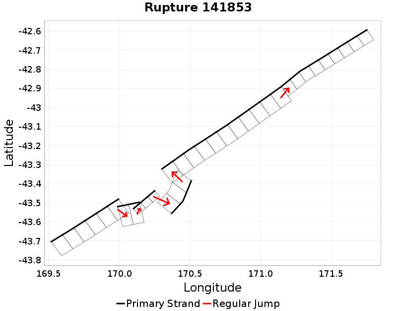
| Length (km) | Magnitude | # Subsections | # Clusters | Area (km^2) |
|---|---|---|---|---|
| 239.8 | 7.5 | 34 | 6 | 3,619.2 |
| Maximum Jump Distance (km) | Cumulative Jump Distance (km) | Ideal Length Ratio | Ideal Length Difference | Rake (degrees) |
| 2.6 | 4.7 | 1.1 | 20.5 | -30.5 |
| Cumulative Rake Change (degrees) | # Mechanism Changes | Cumulative Azimuth Change (degrees) | BS '16-'17 Prob | |
| 355 | 0.0 | 558.8 | 0.02786502 |
Text representation:
[18:129,130,131,132,133,134][563:3174,3175][358:2055,2054,2053][363:2078,2077,2076][18:139,140,141,142,143,144,145,146,147,148,149][19:165,164,163,162,161,160,159,158,157]
Fault section list. First section listed is South West relative to the last section.
- Alpine: Jacksons to Kaniere
- 129, 130, 131, 132, 133, 134 (jump to 3174, 2.6km)
- Straight Creek
- 3174, 3175 (jump to 2055, 0.2km)
- Mt Roon
- 2055, 2054, 2053 (jump to 2078, 1.7km)
- Murchison 1 - Ice Lake
- 2078, 2077, 2076 (jump to 139, 0.1km)
- Alpine: Jacksons to Kaniere
- 139, 140, 141, 142, 143, 144, 145, 146, 147, 148, 149 (jump to 165, 0km)
- Alpine: Kaniere to Springs Junction
- 165, 164, 163, 162, 161, 160, 159, 158, 157