Rupture 650684
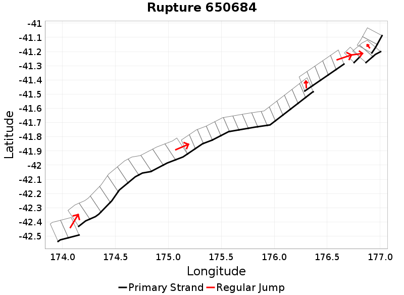
| Length (km) | Magnitude | # Subsections | # Clusters | Area (km^2) |
|---|---|---|---|---|
| 307.8 | 7.7 | 37 | 7 | 5,495 |
| Maximum Jump Distance (km) | Cumulative Jump Distance (km) | Ideal Length Ratio | Ideal Length Difference | Rake (degrees) |
| 4.4 | 12.9 | 1 | 7.3 | -71.8 |
| Cumulative Rake Change (degrees) | # Mechanism Changes | Cumulative Azimuth Change (degrees) | BS '16-'17 Prob | |
| 130 | 4 | 550.6 | 9.509516E-8 |
Text representation:
[316:1834,1835][250:1441,1440,1439,1438,1437,1436,1435,1434,1433,1432][446:2459,2460,2461,2462,2463,2464,2465,2466,2467,2468,2469,2470,2471,2472,2473][426:2374,2375,2376,2377,2378][618:3444][474:2653,2652][615:3427,3428]
Fault section list. First section listed is South West relative to the last section.
- Marlborough Slope 2
- 1834, 1835 (jump to 1441, 4.4km)
- Kekerengu Bank
- 1441, 1440, 1439, 1438, 1437, 1436, 1435, 1434, 1433, 1432 (jump to 2459, 0km)
- Pahaua
- 2459, 2460, 2461, 2462, 2463, 2464, 2465, 2466, 2467, 2468, 2469, 2470, 2471, 2472, 2473 (jump to 2374, 2.7km)
- Opouawe - Uruti
- 2374, 2375, 2376, 2377, 2378 (jump to 3444, 4km)
- Uruti Ridge 2
- 3444 (jump to 2653, 1.5km)
- Porangahau Basin
- 2653, 2652 (jump to 3427, 0.3km)
- Uruti East - PorWest 1
- 3427, 3428