Rupture 281749
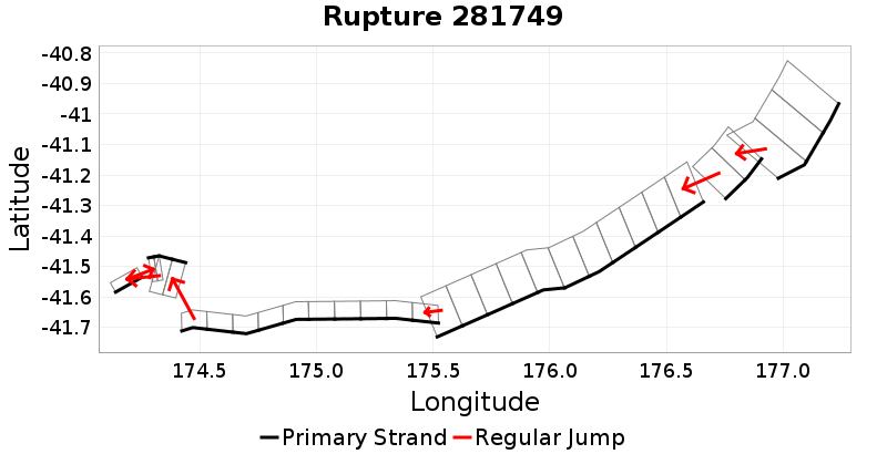
| Length (km) | Magnitude | # Subsections | # Clusters | Area (km^2) |
|---|---|---|---|---|
| 280.4 | 7.7 | 31 | 7 | 5,997.8 |
| Maximum Jump Distance (km) | Cumulative Jump Distance (km) | Ideal Length Ratio | Ideal Length Difference | Rake (degrees) |
| 7.7 | 20.6 | 1 | 12.5 | -51.3 |
| Cumulative Rake Change (degrees) | # Mechanism Changes | Cumulative Azimuth Change (degrees) | BS '16-'17 Prob | |
| 340 | 5 | 528.9 | 1.1620477E-8 |
Text representation:
[474:1867,1868,1869][618:2382,2383][426:1684,1683,1682,1681,1680,1679,1678,1677,1676,1675,1674][61:289,290,291,292,293,294,295,296,297,298][101:473,474][40:216][100:472,471]
Fault section list. First section listed is North East relative to the last section.
- Porangahau Basin
- 1867, 1868, 1869 (jump to 2382, 0.9km)
- Uruti Ridge 2
- 2382, 2383 (jump to 1684, 2.4km)
- Opouawe - Uruti
- 1684, 1683, 1682, 1681, 1680, 1679, 1678, 1677, 1676, 1675, 1674 (jump to 289, 0.2km)
- BooBoo
- 289, 290, 291, 292, 293, 294, 295, 296, 297, 298 (jump to 473, 7.7km)
- Cloudy 3
- 473, 474 (jump to 216, 5.3km)
- Awatere: Northeast 2
- 216 (jump to 472, 4km)
- Cloudy 2
- 472, 471