Rupture 248904
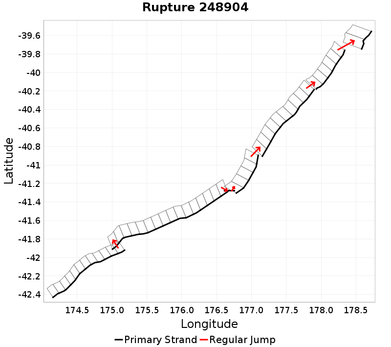
| Length (km) | Magnitude | # Subsections | # Clusters | Area (km^2) |
|---|---|---|---|---|
| 514.7 | 8 | 53 | 7 | 10,683.8 |
| Maximum Jump Distance (km) | Cumulative Jump Distance (km) | Ideal Length Ratio | Ideal Length Difference | Rake (degrees) |
| 8.4 | 19.9 | 1 | 15.6 | -81.6 |
| Cumulative Rake Change (degrees) | # Mechanism Changes | Cumulative Azimuth Change (degrees) | BS '16-'17 Prob | |
| 225 | 3 | 747.4 | 9.4487785E-7 |
Text representation:
[250:1006,1005,1004,1003,1002,1001,1000,999,998,997,996,995][426:1669,1670,1671,1672,1673,1674,1675,1676,1677,1678,1679,1680,1681,1682,1683,1684][613:2363,2364][615:2368,2369,2370,2371,2372][473:1855,1856,1857,1858,1859,1860,1861,1862,1863,1864][455:1794,1793,1792,1791,1790,1789][529:2061,2060]
Fault section list. First section listed is South West relative to the last section.
- Kekerengu Bank
- 1006, 1005, 1004, 1003, 1002, 1001, 1000, 999, 998, 997, 996, 995 (jump to 1669, 5.2km)
- Opouawe - Uruti
- 1669, 1670, 1671, 1672, 1673, 1674, 1675, 1676, 1677, 1678, 1679, 1680, 1681, 1682, 1683, 1684 (jump to 2363, 0.3km)
- Uruti Basin
- 2363, 2364 (jump to 2368, 0.2km)
- Uruti East - PorWest 1
- 2368, 2369, 2370, 2371, 2372 (jump to 1855, 3.8km)
- PorWest2 - PaoanuiRSouth
- 1855, 1856, 1857, 1858, 1859, 1860, 1861, 1862, 1863, 1864 (jump to 1794, 1.9km)
- Paoanui Ridge North
- 1794, 1793, 1792, 1791, 1790, 1789 (jump to 2061, 8.4km)
- Rock Garden - Ritchie East 1
- 2061, 2060