Rupture 398015
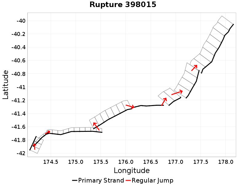
| Length (km) | Magnitude | # Subsections | # Clusters | Area (km^2) |
|---|---|---|---|---|
| 451.7 | 7.9 | 47 | 8 | 9,967.4 |
| Maximum Jump Distance (km) | Cumulative Jump Distance (km) | Ideal Length Ratio | Ideal Length Difference | Rake (degrees) |
| 6.1 | 19 | 1.2 | 63.5 | -57.1 |
| Cumulative Rake Change (degrees) | # Mechanism Changes | Cumulative Azimuth Change (degrees) | BS '16-'17 Prob | |
| 310 | 3 | 876.2 | 3.6024534E-7 |
Text representation:
[295:1192,1191,1190][367:1463,1462,1461,1460][61:298,297,296,295,294,293,292,291,290,289][453:1786,1785,1784,1783,1782,1781,1780][613:2356,2357,2358,2359,2360,2361,2362,2363,2364][474:1870,1869][476:1887,1886,1885,1884][475:1878,1877,1876,1875,1874,1873,1872,1871]
Fault section list. First section listed is South West relative to the last section.
- London Hill
- 1192, 1191, 1190 (jump to 1463, 0.1km)
- Needles
- 1463, 1462, 1461, 1460 (jump to 298, 0.2km)
- BooBoo
- 298, 297, 296, 295, 294, 293, 292, 291, 290, 289 (jump to 1786, 4.2km)
- Palliser - Kaiwhata
- 1786, 1785, 1784, 1783, 1782, 1781, 1780 (jump to 2356, 1.4km)
- Uruti Basin
- 2356, 2357, 2358, 2359, 2360, 2361, 2362, 2363, 2364 (jump to 1870, 6.1km)
- Porangahau Basin
- 1870, 1869 (jump to 1887, 4.4km)
- Porangahau Ridge
- 1887, 1886, 1885, 1884 (jump to 1878, 2.7km)
- Porangahau Northeast
- 1878, 1877, 1876, 1875, 1874, 1873, 1872, 1871