Rupture 329509
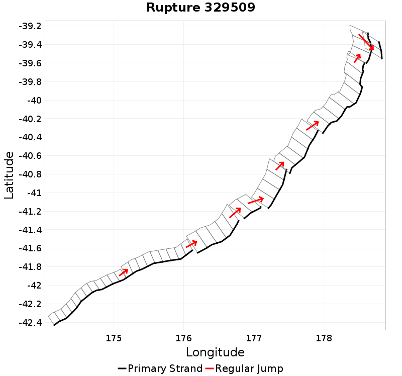
| Length (km) | Magnitude | # Subsections | # Clusters | Area (km^2) |
|---|---|---|---|---|
| 559.5 | 8.1 | 50 | 9 | 13,906.2 |
| Maximum Jump Distance (km) | Cumulative Jump Distance (km) | Ideal Length Ratio | Ideal Length Difference | Rake (degrees) |
| 6.6 | 20.7 | 1.1 | 42.6 | -84.3 |
| Cumulative Rake Change (degrees) | # Mechanism Changes | Cumulative Azimuth Change (degrees) | BS '16-'17 Prob | |
| 45 | 1 | 872.3 | 8.008852E-6 |
Text representation:
[250:1006,1005,1004,1003,1002,1001,1000,999,998,997,996,995][446:1742,1743,1744,1745,1746,1747,1748,1749,1750][487:1931,1930,1929,1928,1927][474:1870,1869][476:1887,1886,1885,1884][475:1878,1877,1876,1875,1874][528:2059,2058,2057,2056,2055,2054,2053,2052][578:2250,2249,2248][452:1778,1777]
Fault section list. First section listed is South West relative to the last section.
- Kekerengu Bank
- 1006, 1005, 1004, 1003, 1002, 1001, 1000, 999, 998, 997, 996, 995 (jump to 1742, 0km)
- Pahaua
- 1742, 1743, 1744, 1745, 1746, 1747, 1748, 1749, 1750 (jump to 1931, 1km)
- Pukeroro 2
- 1931, 1930, 1929, 1928, 1927 (jump to 1870, 1.6km)
- Porangahau Basin
- 1870, 1869 (jump to 1887, 4.4km)
- Porangahau Ridge
- 1887, 1886, 1885, 1884 (jump to 1878, 2.7km)
- Porangahau Northeast
- 1878, 1877, 1876, 1875, 1874 (jump to 2059, 3.7km)
- Rock Garden - Ritchie East
- 2059, 2058, 2057, 2056, 2055, 2054, 2053, 2052 (jump to 2250, 0.8km)
- Te Kapu Bank East
- 2250, 2249, 2248 (jump to 1778, 6.6km)
- Pakupaku Ridge East
- 1778, 1777