Rupture 691057
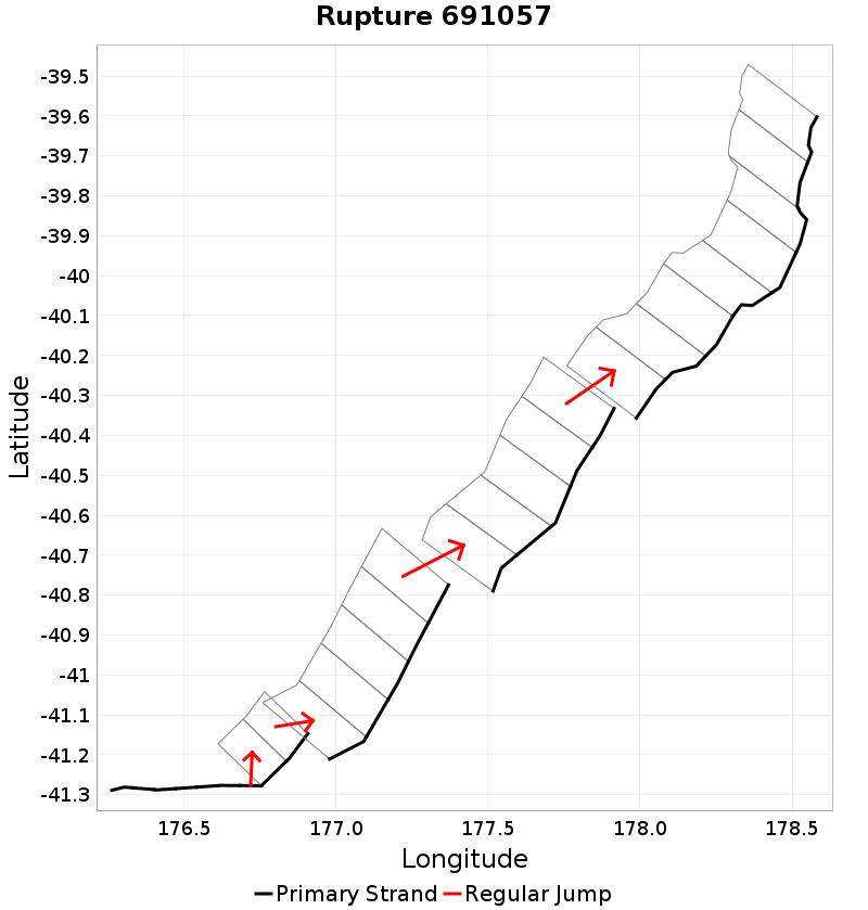
| Length (km) | Magnitude | # Subsections | # Clusters | Area (km^2) |
|---|---|---|---|---|
| 291.3 | 7.8 | 27 | 5 | 7,398.8 |
| Maximum Jump Distance (km) | Cumulative Jump Distance (km) | Ideal Length Ratio | Ideal Length Difference | Rake (degrees) |
| 7.2 | 11.7 | 1.1 | 19.8 | -84.5 |
| Cumulative Rake Change (degrees) | # Mechanism Changes | Cumulative Azimuth Change (degrees) | BS '16-'17 Prob | |
| 90 | 2 | 426.7 | 1.7306865E-4 |
Text representation:
[613:2358,2359,2360,2361,2362,2363,2364][618:2383,2382][474:1869,1868,1867,1866,1865][475:1878,1877,1876,1875,1874][528:2059,2058,2057,2056,2055,2054,2053,2052]
Fault section list. First section listed is South West relative to the last section.
- Uruti Basin
- 2358, 2359, 2360, 2361, 2362, 2363, 2364 (jump to 2383, 0km)
- Uruti Ridge 2
- 2383, 2382 (jump to 1869, 0.9km)
- Porangahau Basin
- 1869, 1868, 1867, 1866, 1865 (jump to 1878, 7.2km)
- Porangahau Northeast
- 1878, 1877, 1876, 1875, 1874 (jump to 2059, 3.7km)
- Rock Garden - Ritchie East
- 2059, 2058, 2057, 2056, 2055, 2054, 2053, 2052