Rupture 612078
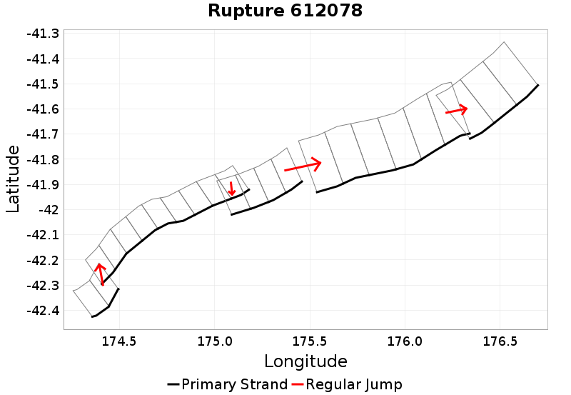
| Length (km) | Magnitude | # Subsections | # Clusters | Area (km^2) |
|---|---|---|---|---|
| 239.6 | 7.7 | 24 | 5 | 5,469.7 |
| Maximum Jump Distance (km) | Cumulative Jump Distance (km) | Ideal Length Ratio | Ideal Length Difference | Rake (degrees) |
| 5.7 | 11.6 | 1.1 | 20.7 | -78.8 |
| Cumulative Rake Change (degrees) | # Mechanism Changes | Cumulative Azimuth Change (degrees) | BS '16-'17 Prob | |
| 90 | 2 | 484.5 | 1.9411753E-4 |
Text representation:
[318:1277,1276][250:1003,1002,1001,1000,999,998,997,996,995][448:1764,1763,1762,1761][164:690,689,688,687,686,685][488:1932,1933,1934]
Fault section list. First section listed is South West relative to the last section.
- Marlborough Slope 4
- 1277, 1276 (jump to 1003, 4.8km)
- Kekerengu Bank
- 1003, 1002, 1001, 1000, 999, 998, 997, 996, 995 (jump to 1764, 0.2km)
- Pahaua SE2
- 1764, 1763, 1762, 1761 (jump to 690, 5.7km)
- Glendhu Ridge
- 690, 689, 688, 687, 686, 685 (jump to 1932, 1km)
- Pukeroro Ridge
- 1932, 1933, 1934