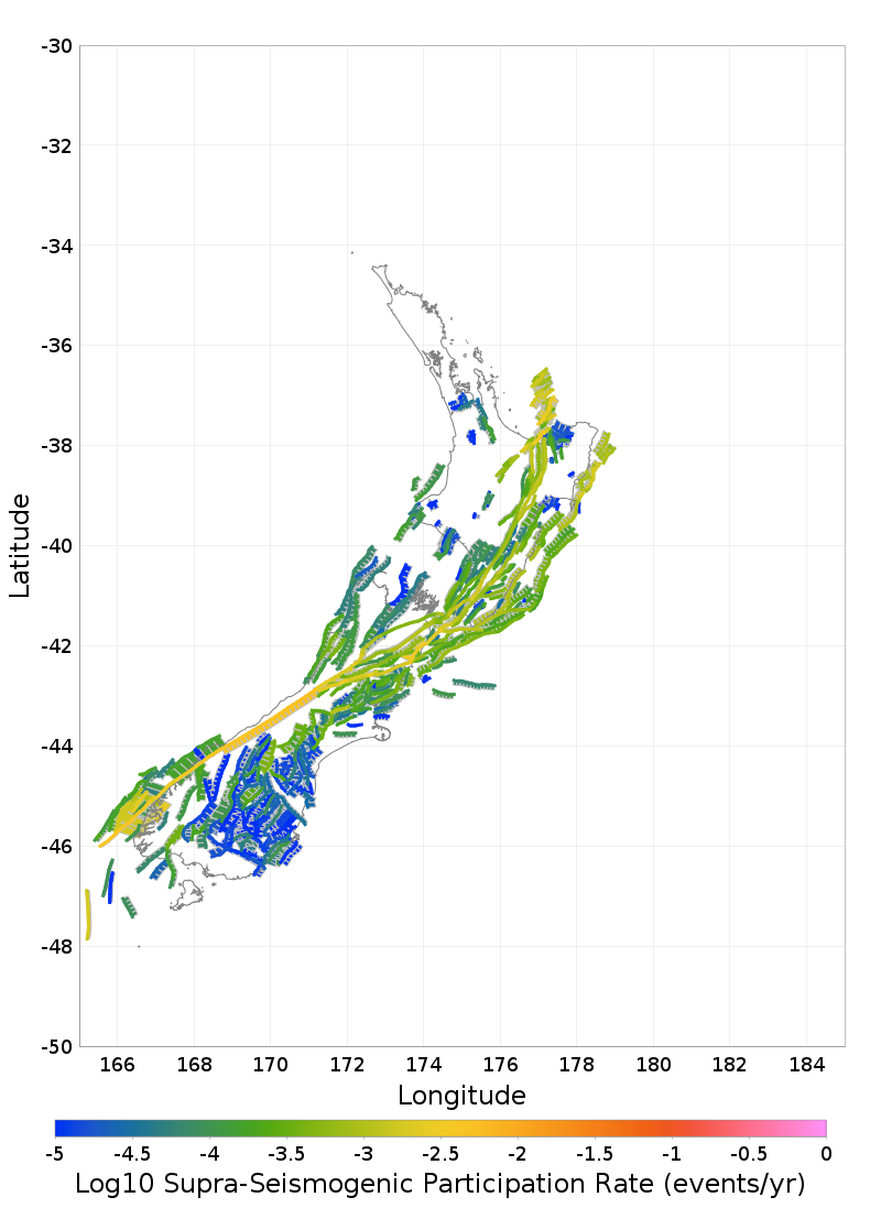
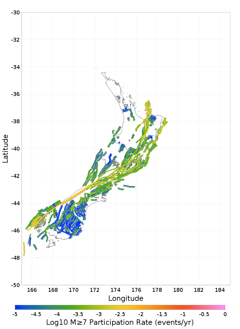
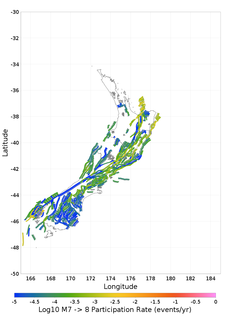
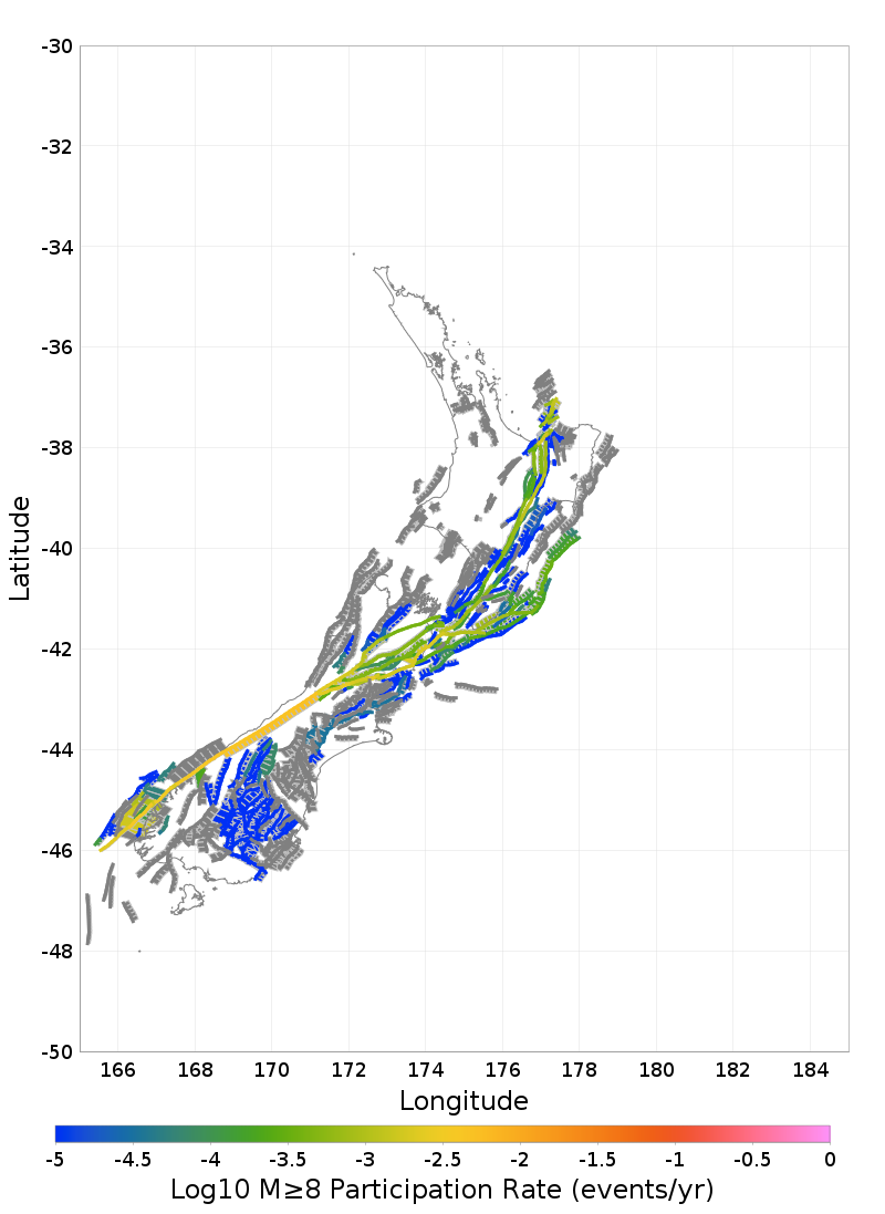
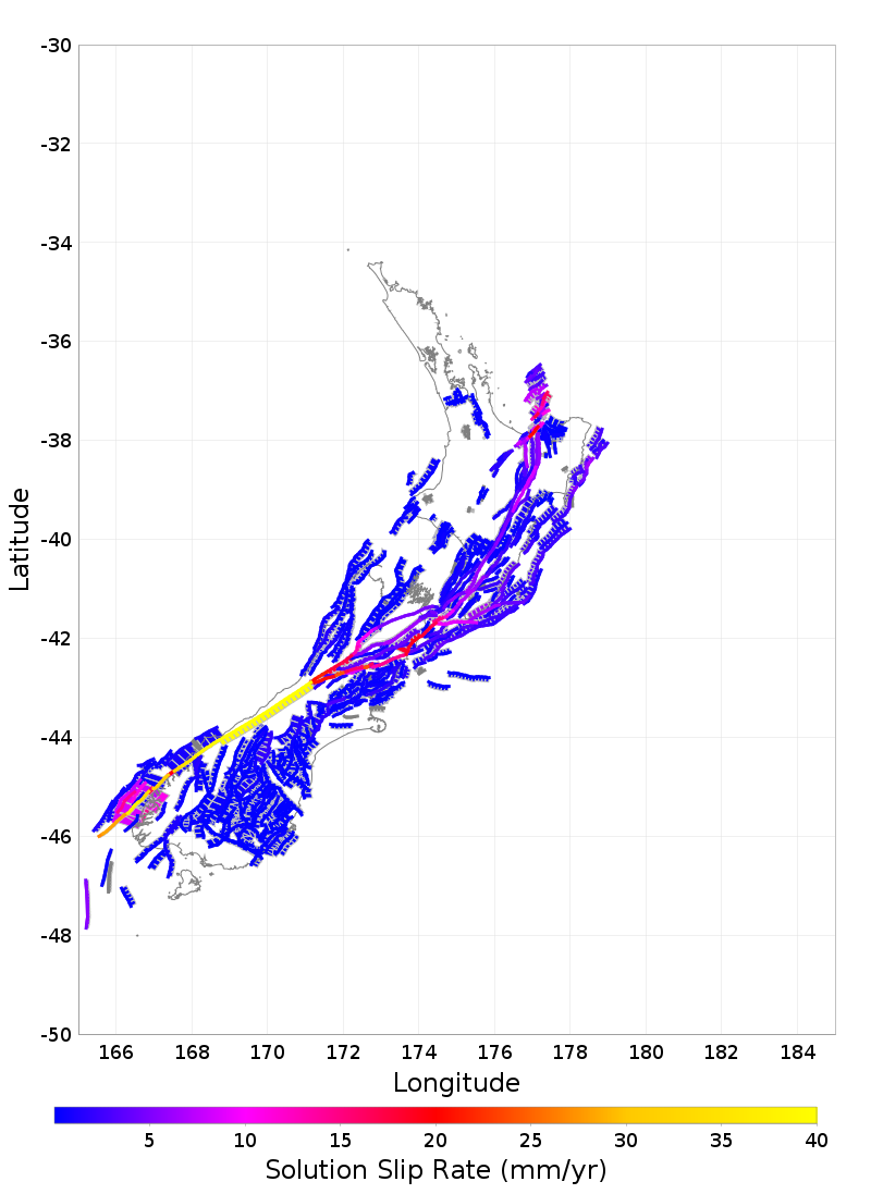
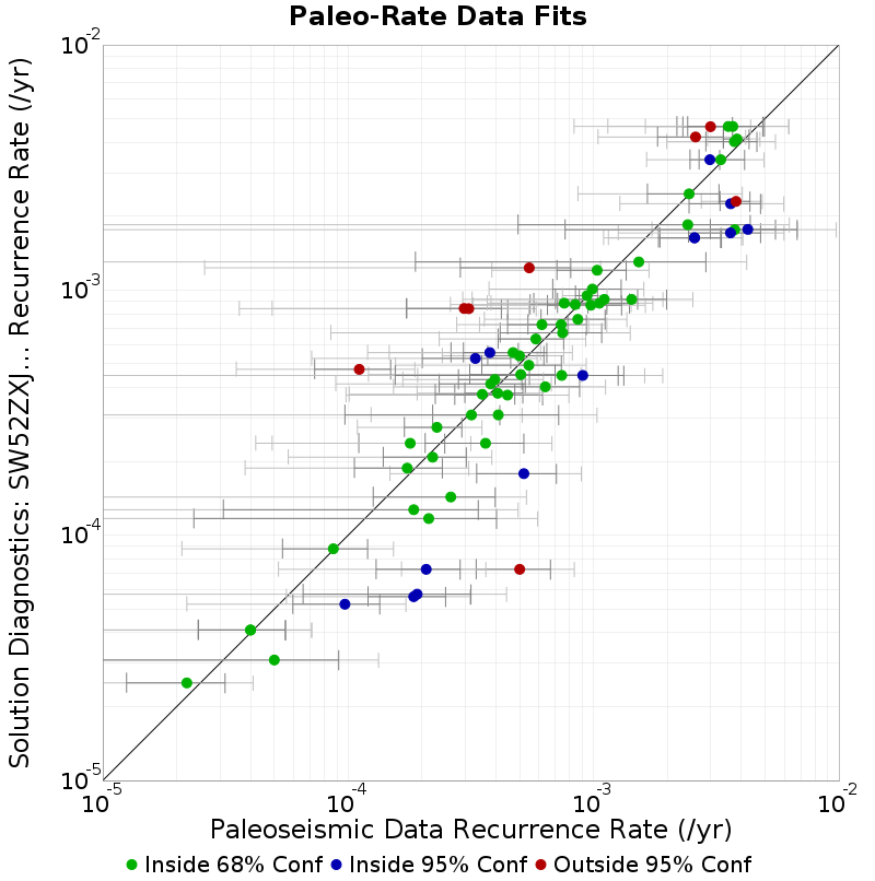
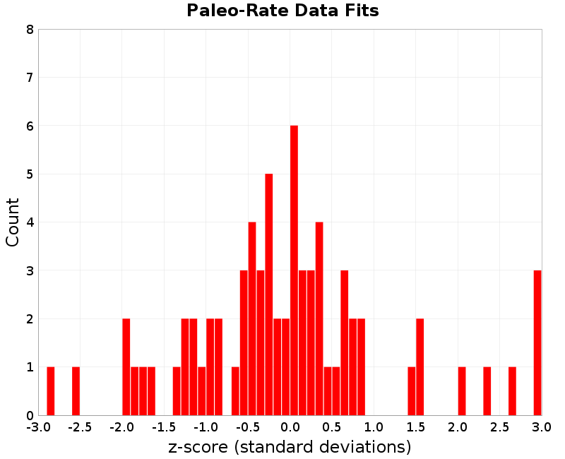
| Alpine George to Jacksons - Hokuri Creek sections | 33 | Alpine: George to Jacksons | 0.00298 | [0.0026925, 0.0032675] | [0.002405, 0.003555] | 2.875E-4 | 0.003400315 | 1.4619656 |
| Akatore - Big Creek trench | 8 | Akatore | 8.7E-5 | [5.4E-5, 1.2E-4] | [2.1E-5, 1.53E-4] | 3.3E-5 | 8.804391E-5 | 0.031633668 |
| Alpine George to Jacksons - Lake Ellery cores | 39 | Alpine: George to Jacksons | 0.003751 | [0.0028695, 0.0046325] | [0.001988, 0.005514] | 8.815E-4 | 0.0040280866 | 0.31433505 |
| Alpine George to Jacksons - John O'Groats Wetland | 32 | Alpine: George to Jacksons | 0.0033 | [0.002473, 0.004127] | [0.001646, 0.004954] | 8.27E-4 | 0.0033995388 | 0.12036129 |
| Alpine Jacksons to Kaniere - Lake Paringa cores | 45 | Alpine: Jacksons to Kaniere | 0.003842 | [0.0033795, 0.0043045] | [0.002917, 0.004767] | 4.625E-4 | 0.0041288207 | 0.6201526 |
| Alpine Jacksons to Kaniere - Lake Mapourika cores | 53 | Alpine: Jacksons to Kaniere | 0.002998 | [0.0023125, 0.0036835] | [0.001627, 0.004369] | 6.855E-4 | 0.004635154 | 2.3882623 |
| Alpine Jacksons to Kaniere - Staples 2 trench | 60 | Alpine: Jacksons to Kaniere | 0.003541 | [0.002187, 0.004895] | [8.33E-4, 0.006249] | 0.001354 | 0.004646114 | 0.8161847 |
| Alpine Jacksons to Kaniere - Staples 3 trench | 60 | Alpine: Jacksons to Kaniere | 0.003695 | [0.0024195, 0.0049705] | [0.001144, 0.006246] | 0.0012755 | 0.004646114 | 0.7456794 |
| Alpine Jacksons to Kaniere - Haast South trench | 42 | Alpine: Jacksons to Kaniere | 0.002605 | [0.001824, 0.003386] | [0.001043, 0.004167] | 7.81E-4 | 0.0042085587 | 2.053212 |
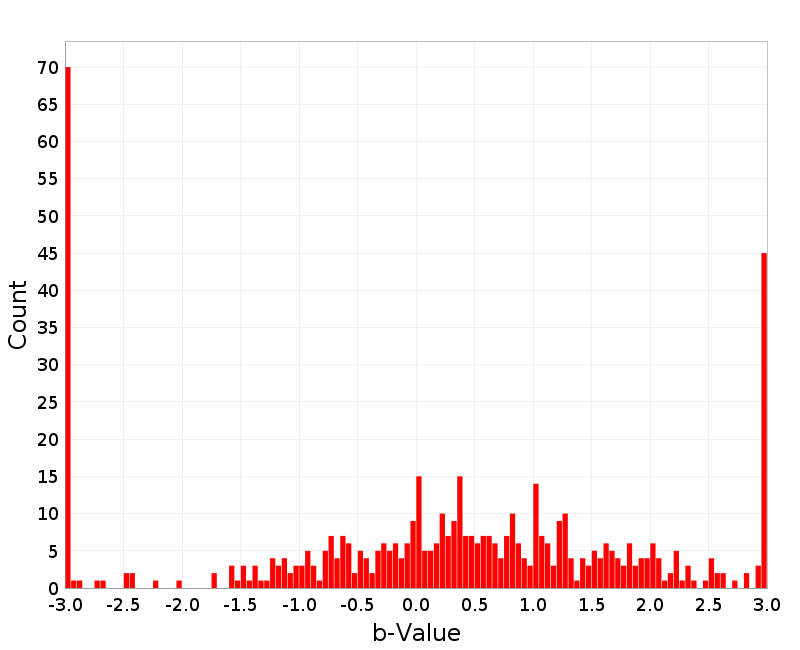
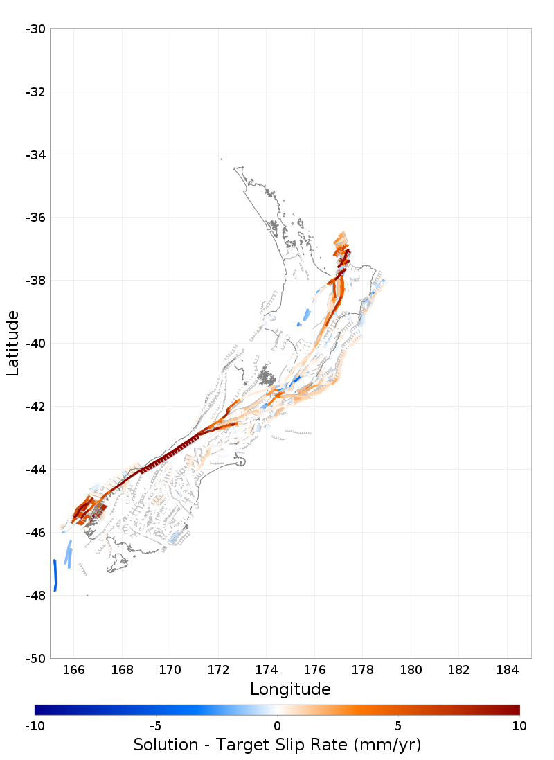
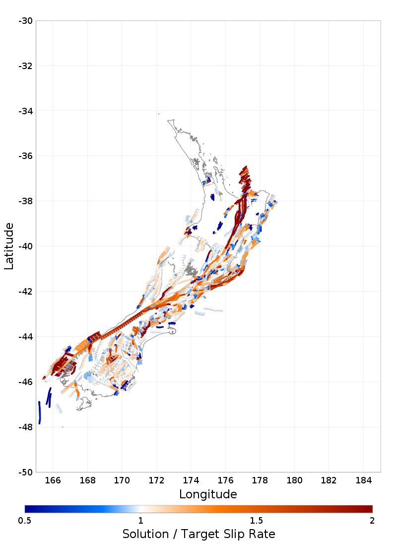
| Alpine Kaniere to Springs Junction - Lake Kaniere cores | 70 | Alpine: Kaniere to Springs Junction | 0.003809 | [0.003279, 0.004339] | [0.002749, 0.004869] | 5.3E-4 | 0.002298554 | -2.849898 |
| Alpine Kaniere to Springs Junction - Lake Brunner cores | 67 | Alpine: Kaniere to Springs Junction | 0.003622 | [0.002451, 0.004793] | [0.00128, 0.005964] | 0.001171 | 0.0022484062 | -1.1730092 |
| Alpine Springs Junction to Tophouse - Maruia Trench-1 | 89 | Alpine: Springs Junction to Tophouse | 0.00258 | [0.001865, 0.003295] | [0.00115, 0.00401] | 7.15E-4 | 0.0016326243 | -1.325001 |
| Alpine Springs Junction to Tophouse - Maruia Trench-2 | 89 | Alpine: Springs Junction to Tophouse | 0.00258 | [0.0018395, 0.0033205] | [0.001099, 0.004061] | 7.405E-4 | 0.0016326243 | -1.279373 |
| Awatere Northeast 1 - Upcot 1 trench | 128 | Awatere: Northeast 1 | 9.89E-4 | [6.82E-4, 0.001296] | [3.75E-4, 0.001603] | 3.07E-4 | 0.0010091341 | 0.06558339 |
| Clarence Northeast - Ravine Stream exposure | 348 | Clarence: Northeast | 4.99E-4 | [3.705E-4, 6.275E-4] | [2.42E-4, 7.56E-4] | 1.285E-4 | 5.391929E-4 | 0.31278512 |
| Cloudy 2 - Cloudy seismic lines | 365 | Cloudy 2 | 3.18E-4 | [2.21E-4, 4.15E-4] | [1.24E-4, 5.12E-4] | 9.7E-5 | 3.0930483E-4 | -0.089640826 |
| Dunstan - T04/2 | 424 | Dunstan | 2.21E-4 | [1.39E-4, 3.03E-4] | [5.7E-5, 3.85E-4] | 8.2E-5 | 2.0812033E-4 | -0.15706913 |
| Te Ikaarongamai - Pakarae River mouth | 1669 | Te Ikaarongamai | 8.63E-4 | [6.11E-4, 0.001115] | [3.59E-4, 0.001367] | 2.52E-4 | 7.5922406E-4 | -0.4118094 |
| Gable End North - Puatai Beach trench | 510 | Gable End North | 0.001034 | [7.095E-4, 0.0013585] | [3.85E-4, 0.001683] | 3.245E-4 | 0.001204078 | 0.5241233 |
| Inglewood - Egmont Road trenches | 713 | Inglewood | 1.65E-4 | [1.0E-4, 2.3E-4] | [3.5E-5, 2.95E-4] | 6.5E-5 | 0.0 | -2.5384614 |
| Inglewood - Everett Park trench | 712 | Inglewood | 1.65E-4 | [1.005E-4, 2.295E-4] | [3.6E-5, 2.94E-4] | 6.45E-5 | 0.0 | -2.5581396 |
| Kaiapo - Te Mihi outcrop | 732 | Kaiapo | 1.79E-4 | [1.105E-4, 2.475E-4] | [4.2E-5, 3.16E-4] | 6.85E-5 | 2.3713072E-4 | 0.84862363 |
| Kaiapo - Lilburn trench fault zone A | 732 | Kaiapo | 3.63E-4 | [2.06E-4, 5.2E-4] | [4.9E-5, 6.77E-4] | 1.57E-4 | 2.3713072E-4 | -0.8017152 |
| Kekerengu 1 - Kekerengu Trench 1 | 769 | Kekerengu 1 | 0.002452 | [0.001658, 0.003246] | [8.64E-4, 0.00404] | 7.94E-4 | 0.0024666546 | 0.018456846 |
| Kina - Kina Fault trench | 1200 | Oaonui | 5.0E-4 | [3.325E-4, 6.675E-4] | [1.65E-4, 8.35E-4] | 1.675E-4 | 7.26033E-5 | -2.5516222 |
| Lachlan 3 - Table Cape trenches | 865 | Lachlan 3 | 8.42E-4 | [5.515E-4, 0.0011325] | [2.61E-4, 0.001423] | 2.905E-4 | 8.72723E-4 | 0.10575914 |
| Maleme - Huffadine trench | 968 | Maleme | 2.3E-4 | [1.695E-4, 2.905E-4] | [1.09E-4, 3.51E-4] | 6.05E-5 | 2.7544683E-4 | 0.7511872 |
| Mohaka South - McCool 1 Trench | 1058 | Mohaka: South | 3.3E-4 | [2.005E-4, 4.595E-4] | [7.1E-5, 5.89E-4] | 1.295E-4 | 5.2597537E-4 | 1.5133235 |
| Mokonui Southwest - Viewfield Trench | 1065 | Mokonui Southwest | 5.2E-4 | [3.34E-4, 7.06E-4] | [1.48E-4, 8.92E-4] | 1.86E-4 | 1.7828846E-4 | -1.8371588 |
| Oaonui - Oaonui coastal cliff exposure | 1200 | Oaonui | 2.08E-4 | [1.3E-4, 2.86E-4] | [5.2E-5, 3.64E-4] | 7.8E-5 | 7.26033E-5 | -1.7358551 |
| Ohariu - Taupo Swamp | 1211 | Ohariu | 6.36E-4 | [3.945E-4, 8.775E-4] | [1.53E-4, 0.001119] | 2.415E-4 | 4.0297426E-4 | -0.9649099 |
| Ohariu - MacKays Crossing Trench | 1209 | Ohariu | 4.46E-4 | [2.72E-4, 6.2E-4] | [9.8E-5, 7.94E-4] | 1.74E-4 | 3.7279562E-4 | -0.42071483 |
| Pihama - Pihama coastal cliff exposure | 1403 | Pihama | 1.85E-4 | [1.205E-4, 2.495E-4] | [5.6E-5, 3.14E-4] | 6.45E-5 | 5.616093E-5 | -1.997505 |
| Porters Pass - Porters Pass Trench 1 | 1423 | Porters Pass | 5.82E-4 | [4.085E-4, 7.555E-4] | [2.35E-4, 9.29E-4] | 1.735E-4 | 6.313448E-4 | 0.28440794 |
| Poutu - Poutu transect 6- fault 6d | 1436 | Poutu | 2.2E-5 | [1.25E-5, 3.15E-5] | [3.0E-6, 4.1E-5] | 9.5E-6 | 2.4981806E-5 | 0.31387436 |
| Ruahine North - Davis Trenches | 1528 | Ruahine: North | 5.45E-4 | [3.505E-4, 7.395E-4] | [1.56E-4, 9.34E-4] | 1.945E-4 | 4.933689E-4 | -0.26545545 |
| Titri Central - Clarendon T16/03 trench | 1703 | Titri Central | 9.7E-5 | [5.95E-5, 1.345E-4] | [2.2E-5, 1.72E-4] | 3.75E-5 | 5.2315176E-5 | -1.1915953 |
| Waihi South - Waihi transect 12- fault 5a | 1809 | Waihi South | 4.0E-5 | [2.45E-5, 5.55E-5] | [9.0E-6, 7.1E-5] | 1.55E-5 | 4.1054576E-5 | 0.068037264 |
| Waihi South - Waihi transect 14- fault 6b | 1809 | Waihi South | 4.0E-5 | [2.45E-5, 5.55E-5] | [9.0E-6, 7.1E-5] | 1.55E-5 | 4.1054576E-5 | 0.068037264 |
| Waimana North - Moana trench | 1829 | Waimana: North | 3.1E-4 | [1.73E-4, 4.47E-4] | [3.6E-5, 5.84E-4] | 1.37E-4 | 8.394393E-4 | 3.86452 |
| Waimana North - Te Hoe / Hautapu Trench | 1835 | Waimana: South | 5.47E-4 | [2.865E-4, 8.075E-4] | [2.6E-5, 0.001068] | 2.605E-4 | 0.0012313398 | 2.627024 |
| Waimana North - Ahirau 1 trench | 1831 | Waimana: North | 2.97E-4 | [1.73E-4, 4.21E-4] | [4.9E-5, 5.45E-4] | 1.24E-4 | 8.407784E-4 | 4.3853097 |
| Waipukaka - Hendricksen Trench 1 | 1884 | Waipukaka | 2.62E-4 | [1.265E-4, 3.975E-4] | [-9.0E-6, 5.33E-4] | 1.355E-4 | 1.431691E-4 | -0.8769808 |
| Wairarapa - Turakirae Head | 1894 | Wairarapa: 1 | 3.78E-4 | [2.625E-4, 4.935E-4] | [1.47E-4, 6.09E-4] | 1.155E-4 | 5.5560085E-4 | 1.5376697 |
| Wairarapa - Lake Kohangapiripiri KP99-1&2 | 1894 | Wairarapa: 1 | 4.7E-4 | [2.95E-4, 6.45E-4] | [1.2E-4, 8.2E-4] | 1.75E-4 | 5.5560085E-4 | 0.4891477 |
| Wairarapa 3 - Tea Creek Road | 1902 | Wairarapa: 3 | 3.81E-4 | [2.35E-4, 5.27E-4] | [8.9E-5, 6.73E-4] | 1.46E-4 | 4.140838E-4 | 0.22660144 |
| Wairau - Wadsworth Trench | 1917 | Wairau | 9.04E-4 | [5.48E-4, 0.00126] | [1.92E-4, 0.001616] | 3.56E-4 | 4.4850432E-4 | -1.2794822 |
| Wairau - Dillon Trench | 1916 | Wairau | 5.05E-4 | [3.13E-4, 6.97E-4] | [1.21E-4, 8.89E-4] | 1.92E-4 | 4.5225568E-4 | -0.2747099 |
| Wairau 2 - Wairau seismic lines | 1924 | Wairau 2 | 4.07E-4 | [2.99E-4, 5.15E-4] | [1.91E-4, 6.23E-4] | 1.08E-4 | 3.7931284E-4 | -0.25636247 |
| Wellington Hutt Valley 3 - Te Kopahou-1 Trenches | 1979 | Wellington Hutt Valley: 3 | 7.48E-4 | [4.165E-4, 0.0010795] | [8.5E-5, 0.001411] | 3.315E-4 | 6.6910323E-4 | -0.23799938 |
| Wellington Hutt Valley 5 - KAF-1 | 1983 | Wellington Hutt Valley: 5 | 7.6E-4 | [5.71E-4, 9.49E-4] | [3.82E-4, 0.001138] | 1.89E-4 | 8.836654E-4 | 0.6543143 |
| Wellington Hutt Valley 5 - KAF-3 | 1983 | Wellington Hutt Valley: 5 | 0.001057 | [7.13E-4, 0.001401] | [3.69E-4, 0.001745] | 3.44E-4 | 8.836654E-4 | -0.50387967 |
| Wellington Pahiatua - Dougan-1 | 1988 | Wellington: Pahiatua | 0.001106 | [6.995E-4, 0.0015125] | [2.93E-4, 0.001919] | 4.065E-4 | 9.1590785E-4 | -0.4676313 |
| Wellington Pahiatua - Hughes-1 Trench | 1986 | Wellington: Pahiatua | 9.75E-4 | [6.49E-4, 0.001301] | [3.23E-4, 0.001627] | 3.26E-4 | 8.669655E-4 | -0.33139417 |
| Wellington Pahiatua - Dougan-2 | 1988 | Wellington: Pahiatua | 0.00143 | [8.75E-4, 0.001985] | [3.2E-4, 0.00254] | 5.55E-4 | 9.1590785E-4 | -0.9262921 |
| Whakatane North - Te Whetu trench | 2023 | Whakatane: North | 1.11E-4 | [7.3E-5, 1.49E-4] | [3.5E-5, 1.87E-4] | 3.8E-5 | 4.7467937E-4 | 9.57051 |
| Whakatane South - Thalassa trench | 2029 | Whakatane: South | 3.52E-4 | [2.265E-4, 4.775E-4] | [1.01E-4, 6.03E-4] | 1.255E-4 | 3.7554995E-4 | 0.18764901 |
| Awatere Northeast 1 - Combined Taylors Pass Road trenches and Lake Jasper cores | 133 | Awatere: Northeast 1 | 9.41E-4 | [8.44E-4, 0.001038] | [7.47E-4, 0.001135] | 9.7E-5 | 9.487891E-4 | 0.08030049 |
| Hope Conway - Combined Greenburn East and West trenches | 614 | Hope: Conway | 0.004253 | [0.002992, 0.005514] | [0.001731, 0.006775] | 0.001261 | 0.0017679058 | -1.9707329 |
| Hope Hope River - Hope Shelter trenches combined | 627 | Hope: Hope River | 0.003617 | [0.002439, 0.004795] | [0.001261, 0.005973] | 0.001178 | 0.0017098249 | -1.6189941 |
| Paeroa - Combined Paeroa trenches | 1340 | Paeroa | 3.96E-4 | [2.815E-4, 5.105E-4] | [1.67E-4, 6.25E-4] | 1.145E-4 | 4.3151373E-4 | 0.3101637 |
| Poukawa - Combined Poukawa trenches | 1888 | Waipukurau - Poukawa | 1.74E-4 | [1.06E-4, 2.42E-4] | [3.8E-5, 3.1E-4] | 6.8E-5 | 1.8778126E-4 | 0.20266566 |
| Wairarapa 2 - Cross Creek South combined (1- 4) | 1898 | Wairarapa: 2 | 7.38E-4 | [5.405E-4, 9.355E-4] | [3.43E-4, 0.001133] | 1.975E-4 | 7.225391E-4 | -0.07828304 |
| Wairarapa 2 - Cross Creek North combined (2- 3) | 1898 | Wairarapa: 2 | 6.16E-4 | [4.465E-4, 7.855E-4] | [2.77E-4, 9.55E-4] | 1.695E-4 | 7.225391E-4 | 0.6285493 |
| Edgecumbe 1987_5294-5308_Combined | 434 | Edgecumbe 1987 | 0.001529 | [1.88E-4, 0.00287] | [-0.001153, 0.004211] | 0.001341 | 0.0013017252 | -0.16948164 |
| Flaxmore - Waimea - Tahunanui_5507_Wairoa-2 trench | 492 | Flaxmore - Waimea - Tahunanui | 1.91E-4 | [6.55E-5, 3.165E-4] | [-6.0E-5, 4.42E-4] | 1.255E-4 | 5.7492787E-5 | -1.0638025 |
| Fox Peak_4035_Trench 4 | 505 | Fox Peak | 4.09E-4 | [9.7E-5, 7.21E-4] | [-2.15E-4, 0.001033] | 3.12E-4 | 3.0950396E-4 | -0.3188976 |
| Hope Conway_666-675_Combined | 615 | Hope: Conway | 0.003762 | [7.66E-4, 0.006758] | [-0.00223, 0.009754] | 0.002996 | 0.0017628142 | -0.66728497 |
| Hope Hope River_648_Matagouri Flat | 629 | Hope: Hope River | 0.002422 | [4.925E-4, 0.0043515] | [-0.001437, 0.006281] | 0.0019295 | 0.0018463874 | -0.29832214 |
| The Humps_5565-5696_Combined | 1693 | The Humps | 2.13E-4 | [2.35E-5, 4.025E-4] | [-1.66E-4, 5.92E-4] | 1.895E-4 | 1.16938936E-4 | -0.50691855 |
| Wairau_5519-5522_Combined Zinke | 1917 | Wairau | 7.42E-4 | [1.555E-4, 0.0013285] | [-4.31E-4, 0.001915] | 5.865E-4 | 4.4850432E-4 | -0.5004189 |
| Waitawhiti_5369-5379_Combined | 1941 | Waitawhiti | 1.85E-4 | [3.1E-5, 3.39E-4] | [-1.23E-4, 4.93E-4] | 1.54E-4 | 1.2706999E-4 | -0.37616894 |
| Whitemans Valley_1023_Whitemans Valley trench | 2090 | Whitemans Valley | 5.0E-5 | [8.5E-6, 9.15E-5] | [-3.3E-5, 1.33E-4] | 4.15E-5 | 3.0980907E-5 | -0.4582914 |