Solution Report: Solution Diagnostics: SW52ZXJzaW9uU29sdXRpb246MjU2MzAuMHJQandN

Num Ruptures332,000
Num Single-Stranded Ruptures332,000 (100.00%)
Total Supra-Seis Rupture Rate0.028392563
Total Supra-Seis Recurrence Interval35.22 yrs
Total Moment Rate1.8685307e19 N-m/yr
Deformation Model Total Moment Rate2.7523217e19 N-m/yr
Magnitude Range[5.57,8.53]
Length Range[1.86,1204.33] km
Rupture Section Count Range[2,124]

Table Of Contents

Logic Tree Branch

(top)

LevelChoice
Fault Model(N/A)
Fault RegimeFault Regime
NZSHM22_SpatialSeisPDFNZSHM22_1346
Slip Along Rupture Model (Dsr)Uniform
Inversion ModelCharacteristic (Constrained)
NZSHM22_ScalingRelationshipNZSHM22_ScalingRelationship
NZSHM22_DeformationModelFAULT_MODEL

Solution MFDs

(top)

Total Target MFDs

(top)

Incremental MFDsCumulative MFDs
Incremental PlotCumulative Plot

NZ RECTANGLE SANS TVZ Gridded Region

(top)

Incremental MFDsCumulative MFDs
Incremental PlotCumulative Plot

NZ TVZ Gridded Region

(top)

Incremental MFDsCumulative MFDs
Incremental PlotCumulative Plot

Simulated Annealing Energy

(top)

Iterations3,325,655,925
Time2 hours 0.3 mins
Iterations Per Sec.460,745
Perturbations8,072,208
# Worse Pertubations Kept509,037
Iterations Per Perturb.412
Total Energy5853.6

Final Energies

(top)

Energy TypeFinal Energy (2 hours 0.3 mins)% of TotalAfter 30 mins1 hour1 hour 30 mins
Total Energy5853.65862.21885857.70175855.4087
Equality Energy5853.6100.00%5862.21885857.70175855.4087
Entropy Energy0.00.00%0.00.00.0
Inequality Energy0.00.00%0.00.00.0
Uncertain Slip Rate1922.419832.84%1923.60141921.20451921.4302
Paleoseismic Event Rate493.700848.43%495.49298495.31616494.42203
Laplacian Smoothing (49 parents)6.0538114E-60.00%4.5516085E-65.2709224E-65.718186E-6
Rupture Rate Minimization0.00.00%0.00.00.0
Uncertain MFD Equality3437.479558.72%3443.1243441.18143439.557

Energy Progress

(top)

Energy vs Time

Energy vs Iterations

Perturbations

Constraint Misfit Progress

(top)

misfit plot misfit plot misfit plot

Rupture Rate Distribution

(top)

Non-zero ruptures689 (0.21%)
Avg. # perturbations per rupture24.313879
Avg. # perturbations per non-zero rupture11715.832

Rate Distribution

Cumulative Rate Distribution

Participation Rates

(top)

Supra-Seismogenic

Range: M≤6

MapMap
Download GeoJSON Download GeoJSON

M≥6

Range: M∈[6, 7]

MapMap
Download GeoJSON Download GeoJSON

M≥7

Range: M∈[7, 8]

MapMap
Download GeoJSON Download GeoJSON

M≥8

Map
Download GeoJSON

Section b-values

(top)

Subsection b-values

(top)

These plots estimate a Gutenberg-Richter b-value for each subsection and parent section nucleation MFD. This is a rough approximation, and is intended primarily for model comparisons.

Download b-value CSV file: sect_b_values.csv

Section b-values Plot

b-Value Distributionb-Value Rate-Dependence
HistogramScatter

Parent Section b-values

(top)

Download b-value CSV file: parent_sect_b_values.csv

b-Value Distributionb-Value Rate-Dependence
HistogramScatter

Rupture Scalar Histograms

(top)

Rupture Length

(top)

Total length (km) of the rupture, not including jumps or gaps.

hist
hist
hist
hist

Rupture Length vs Rupture Rate

(top)

rate comparisonrate hist

Rupture Magnitude

(top)

Magnitude of the rupture.

hist
hist
hist
hist

Rupture Magnitude vs Rupture Rate

(top)

rate comparisonrate hist

Maximum Jump Dist

(top)

The maximum jump distance in the rupture.

hist
hist
hist
hist

Maximum Jump Dist vs Rupture Rate

(top)

rate comparisonrate hist

Cumulative Jump Dist

(top)

The total cumulative jump distance summed over all jumps in the rupture.

hist
hist
hist
hist

Cumulative Jump Dist vs Rupture Rate

(top)

rate comparisonrate hist

Cumulative Rake Change

(top)

Cumulative rake change for this rupture.

hist
hist
hist
hist

Cumulative Rake Change vs Rupture Rate

(top)

rate comparisonrate hist

Max Slip Rate Difference

(top)

The difference between the slip rate of the sections with the highest and lowest slip rate in the rupture.

hist
hist
hist
hist

Max Slip Rate Difference vs Rupture Rate

(top)

rate comparisonrate hist

Attached Modules

(top)

List of all modules that have been attached to this Solution.

Note: Modules classes in the standard modules package, org.opensha.sha.earthquake.faultSysSolution.modules, have been shortened to omit the package name.

Rupture Set Modules

(top)

NameImplementing Class
Single-Strand Cluster RupturesClusterRuptures$SingleStranded
Section Distance-Azimuth Calculatororg.opensha.sha.earthquake.faultSysSolution.ruptures.util.SectionDistanceAzimuthCalculator
Logic Tree Branchnz.cri.gns.NZSHM22.opensha.enumTreeBranches.NZSHM22_LogicTreeBranch
Polygon Fault Grid AssociationsPolygonFaultGridAssociations$Precomputed
Rupture Connection Searchorg.opensha.sha.earthquake.faultSysSolution.ruptures.util.RuptureConnectionSearch
Section Slip RatesSectSlipRates$Precomputed
Section AreasSectAreas$Default
Inversion Target MFDsInversionTargetMFDs$Precomputed
Precomputed Average SlipsAveSlipModule$Precomputed
Modified Section Minimum MagnitudesModSectMinMags$Precomputed
OpenSHA Build InformationBuildInfoModule
Uniform Slip Along RuptureSlipAlongRuptureModel$Uniform
Paleoseismic Constraint DataPaleoseismicConstraintData

Solution Modules

(top)

NameImplementing Class
Annealing Progressorg.opensha.sha.earthquake.faultSysSolution.inversion.sa.completion.AnnealingProgress
Inversion Misfit ProgressInversionMisfitProgress
OpenSHA Build InformationBuildInfoModule
Sub-Seismogenic On-Fault MFDsSubSeismoOnFaultMFDs

Fault Section Connections

(top)

plot
Download GeoJSON
plot
plot
plot

Connected Clusters

(top)

Connected clusters of fault sections, where all sections plotted in a given color connect with all other sections of the same color through ruptures. There may not be any single rupture that connects all such sections, but rather, chains of ruptures connect the sections. Only the first 10 clusters are plotted, with smaller clusters plotted in gray, and fully isolated faults plotted in black.

Primary clusters
Download GeoJSON
RankSectionsParent SectionsRuptures
11,691 (80.79%)443 (79.53%)329,883 (99.36%)
248 (2.29%)13 (2.33%)314 (0.09%)
339 (1.86%)15 (2.69%)691 (0.21%)
427 (1.29%)10 (1.80%)174 (0.05%)
526 (1.24%)5 (0.90%)134 (0.04%)
626 (1.24%)9 (1.62%)107 (0.03%)
721 (1.00%)2 (0.36%)104 (0.03%)
819 (0.91%)6 (1.08%)112 (0.03%)
912 (0.57%)2 (0.36%)55 (0.02%)
1012 (0.57%)3 (0.54%)51 (0.02%)
11->1320 (0.96%)7 (1.26%)37 (0.01%)
42 isolated152 (7.26%)42 (7.54%)338 (0.10%)

Slip Rates

(top)

Linear Slip Rate Plots

(top)

MapMap
Download GeoJSON Download GeoJSON
MapMap
Download GeoJSON Download GeoJSON
MapMap
Download GeoJSON Download GeoJSON
Diff histDiff hist

Log10 Slip Rate Plots

(top)

MapMap
Download GeoJSON Download GeoJSON
MapMap
Download GeoJSON Download GeoJSON
MapDiff hist
Download GeoJSON

Slip Rate Std Dev Plots

(top)

MapMap
Download GeoJSON Download GeoJSON

Paleoseismic Data Comparison

(top)

Paleo Data Comparison
Paleo Data Fits

Paleo data comparison table. For the solution column, text is bold if within 68% bounds, italicized if within 95% bounds, and otherwise plain text. Download CSV here.

Site NameMapped Subsection IDMapped Parent SectionConstraint Mean Rate68% BoundsConstraint 95% BoundsStd. DevSolution Ratez-score
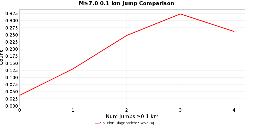
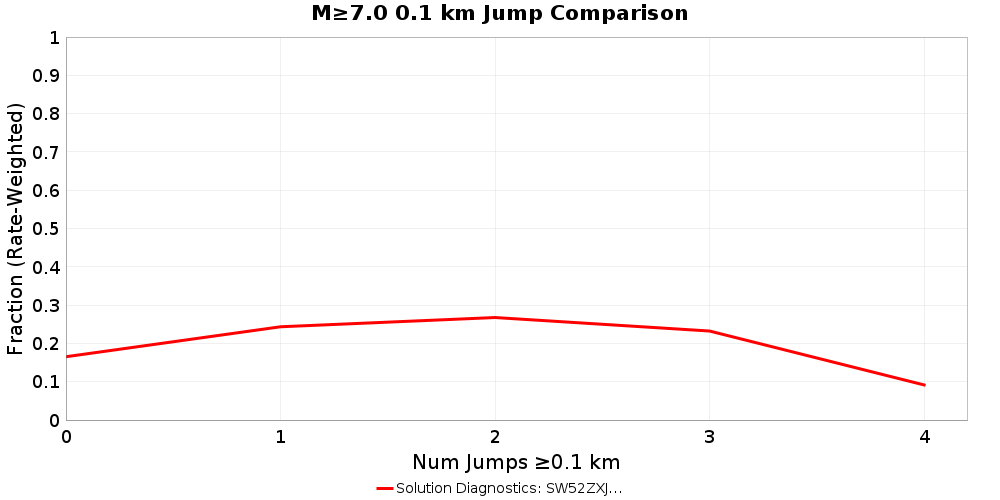
Alpine George to Jacksons - Hokuri Creek sections33Alpine: George to Jacksons0.00298[0.0026925, 0.0032675][0.002405, 0.003555]2.875E-40.0028698805-0.38302413
Akatore - Big Creek trench8Akatore8.7E-5[5.4E-5, 1.2E-4][2.1E-5, 1.53E-4]3.3E-58.144314E-5-0.16838968
Alpine George to Jacksons - Lake Ellery cores39Alpine: George to Jacksons0.003751[0.0028695, 0.0046325][0.001988, 0.005514]8.815E-40.0028756862-0.99298215
Alpine George to Jacksons - John O'Groats Wetland32Alpine: George to Jacksons0.0033[0.002473, 0.004127][0.001646, 0.004954]8.27E-40.0028673457-0.5231612
Alpine Jacksons to Kaniere - Lake Paringa cores45Alpine: Jacksons to Kaniere0.003842[0.0033795, 0.0043045][0.002917, 0.004767]4.625E-40.002933437-1.9644605
Alpine Jacksons to Kaniere - Lake Mapourika cores53Alpine: Jacksons to Kaniere0.002998[0.0023125, 0.0036835][0.001627, 0.004369]6.855E-40.0025056228-0.7182744
Alpine Jacksons to Kaniere - Staples 2 trench60Alpine: Jacksons to Kaniere0.003541[0.002187, 0.004895][8.33E-4, 0.006249]0.0013540.0033028678-0.1758731
Alpine Jacksons to Kaniere - Staples 3 trench60Alpine: Jacksons to Kaniere0.003695[0.0024195, 0.0049705][0.001144, 0.006246]0.00127550.0033028678-0.30743408
Alpine Jacksons to Kaniere - Haast South trench42Alpine: Jacksons to Kaniere0.002605[0.001824, 0.003386][0.001043, 0.004167]7.81E-40.0028820020.3546759
Alpine Kaniere to Springs Junction - Lake Kaniere cores70Alpine: Kaniere to Springs Junction0.003809[0.003279, 0.004339][0.002749, 0.004869]5.3E-40.0025032638-2.4636533
Alpine Kaniere to Springs Junction - Lake Brunner cores67Alpine: Kaniere to Springs Junction0.003622[0.002451, 0.004793][0.00128, 0.005964]0.0011710.0023201916-1.1117065
Alpine Springs Junction to Tophouse - Maruia Trench-189Alpine: Springs Junction to Tophouse0.00258[0.001865, 0.003295][0.00115, 0.00401]7.15E-40.0013208479-1.7610519
Alpine Springs Junction to Tophouse - Maruia Trench-289Alpine: Springs Junction to Tophouse0.00258[0.0018395, 0.0033205][0.001099, 0.004061]7.405E-40.0013208479-1.700408
Awatere Northeast 1 - Upcot 1 trench128Awatere: Northeast 19.89E-4[6.82E-4, 0.001296][3.75E-4, 0.001603]3.07E-48.1501255E-4-0.5667343
Clarence Northeast - Ravine Stream exposure348Clarence: Northeast4.99E-4[3.705E-4, 6.275E-4][2.42E-4, 7.56E-4]1.285E-44.6209907E-4-0.28716686
Cloudy 2 - Cloudy seismic lines365Cloudy 23.18E-4[2.21E-4, 4.15E-4][1.24E-4, 5.12E-4]9.7E-53.0124048E-4-0.17277849
Dunstan - T04/2424Dunstan2.21E-4[1.39E-4, 3.03E-4][5.7E-5, 3.85E-4]8.2E-51.8232035E-4-0.4717031
Te Ikaarongamai - Pakarae River mouth1669Te Ikaarongamai8.63E-4[6.11E-4, 0.001115][3.59E-4, 0.001367]2.52E-46.441966E-4-0.8682675
Gable End North - Puatai Beach trench510Gable End North0.001034[7.095E-4, 0.0013585][3.85E-4, 0.001683]3.245E-48.3586265E-4-0.61059266
Inglewood - Egmont Road trenches713Inglewood1.65E-4[1.0E-4, 2.3E-4][3.5E-5, 2.95E-4]6.5E-50.0-2.5384614
Inglewood - Everett Park trench712Inglewood1.65E-4[1.005E-4, 2.295E-4][3.6E-5, 2.94E-4]6.45E-50.0-2.5581396
Kaiapo - Te Mihi outcrop732Kaiapo1.79E-4[1.105E-4, 2.475E-4][4.2E-5, 3.16E-4]6.85E-52.1693064E-40.55373204
Kaiapo - Lilburn trench fault zone A732Kaiapo3.63E-4[2.06E-4, 5.2E-4][4.9E-5, 6.77E-4]1.57E-42.1693064E-4-0.9303781
Kekerengu 1 - Kekerengu Trench 1769Kekerengu 10.002452[0.001658, 0.003246][8.64E-4, 0.00404]7.94E-40.0016418283-1.0203673
Kina - Kina Fault trench1200Oaonui5.0E-4[3.325E-4, 6.675E-4][1.65E-4, 8.35E-4]1.675E-41.0723793E-4-2.3448482
Lachlan 3 - Table Cape trenches865Lachlan 38.42E-4[5.515E-4, 0.0011325][2.61E-4, 0.001423]2.905E-46.987352E-4-0.49316642
Maleme - Huffadine trench968Maleme2.3E-4[1.695E-4, 2.905E-4][1.09E-4, 3.51E-4]6.05E-52.3966284E-40.15971626
Mohaka South - McCool 1 Trench1058Mohaka: South3.3E-4[2.005E-4, 4.595E-4][7.1E-5, 5.89E-4]1.295E-43.6718676E-40.2871565
Mokonui Southwest - Viewfield Trench1065Mokonui Southwest5.2E-4[3.34E-4, 7.06E-4][1.48E-4, 8.92E-4]1.86E-42.3217157E-4-1.5474646
Oaonui - Oaonui coastal cliff exposure1200Oaonui2.08E-4[1.3E-4, 2.86E-4][5.2E-5, 3.64E-4]7.8E-51.0723793E-4-1.2918215
Ohariu - Taupo Swamp1211Ohariu6.36E-4[3.945E-4, 8.775E-4][1.53E-4, 0.001119]2.415E-44.5559191E-4-0.74703145
Ohariu - MacKays Crossing Trench1209Ohariu4.46E-4[2.72E-4, 6.2E-4][9.8E-5, 7.94E-4]1.74E-44.096927E-4-0.20866263
Pihama - Pihama coastal cliff exposure1403Pihama1.85E-4[1.205E-4, 2.495E-4][5.6E-5, 3.14E-4]6.45E-56.731881E-5-1.8245146
Porters Pass - Porters Pass Trench 11423Porters Pass5.82E-4[4.085E-4, 7.555E-4][2.35E-4, 9.29E-4]1.735E-46.083409E-40.15182063
Poutu - Poutu transect 6- fault 6d1436Poutu2.2E-5[1.25E-5, 3.15E-5][3.0E-6, 4.1E-5]9.5E-60.0-2.3157895
Ruahine North - Davis Trenches1528Ruahine: North5.45E-4[3.505E-4, 7.395E-4][1.56E-4, 9.34E-4]1.945E-43.1355282E-4-1.1899598
Titri Central - Clarendon T16/03 trench1703Titri Central9.7E-5[5.95E-5, 1.345E-4][2.2E-5, 1.72E-4]3.75E-56.899845E-5-0.746708
Waihi South - Waihi transect 12- fault 5a1809Waihi South4.0E-5[2.45E-5, 5.55E-5][9.0E-6, 7.1E-5]1.55E-50.0-2.580645
Waihi South - Waihi transect 14- fault 6b1809Waihi South4.0E-5[2.45E-5, 5.55E-5][9.0E-6, 7.1E-5]1.55E-50.0-2.580645
Waimana North - Moana trench1829Waimana: North3.1E-4[1.73E-4, 4.47E-4][3.6E-5, 5.84E-4]1.37E-43.893265E-40.5790257
Waimana North - Te Hoe / Hautapu Trench1835Waimana: South5.47E-4[2.865E-4, 8.075E-4][2.6E-5, 0.001068]2.605E-45.446996E-4-0.008830668
Waimana North - Ahirau 1 trench1831Waimana: North2.97E-4[1.73E-4, 4.21E-4][4.9E-5, 5.45E-4]1.24E-43.905543E-40.75447017
Waipukaka - Hendricksen Trench 11884Waipukaka2.62E-4[1.265E-4, 3.975E-4][-9.0E-6, 5.33E-4]1.355E-41.4951169E-4-0.83017206
Wairarapa - Turakirae Head1894Wairarapa: 13.78E-4[2.625E-4, 4.935E-4][1.47E-4, 6.09E-4]1.155E-44.7569445E-40.8458394
Wairarapa - Lake Kohangapiripiri KP99-1&21894Wairarapa: 14.7E-4[2.95E-4, 6.45E-4][1.2E-4, 8.2E-4]1.75E-44.7569445E-40.032539707
Wairarapa 3 - Tea Creek Road1902Wairarapa: 33.81E-4[2.35E-4, 5.27E-4][8.9E-5, 6.73E-4]1.46E-43.9973028E-40.12828961
Wairau - Wadsworth Trench1917Wairau9.04E-4[5.48E-4, 0.00126][1.92E-4, 0.001616]3.56E-45.41813E-4-1.0173793
Wairau - Dillon Trench1916Wairau5.05E-4[3.13E-4, 6.97E-4][1.21E-4, 8.89E-4]1.92E-45.3976214E-40.18105286
Wairau 2 - Wairau seismic lines1924Wairau 24.07E-4[2.99E-4, 5.15E-4][1.91E-4, 6.23E-4]1.08E-44.4665736E-40.3671979
Wellington Hutt Valley 3 - Te Kopahou-1 Trenches1979Wellington Hutt Valley: 37.48E-4[4.165E-4, 0.0010795][8.5E-5, 0.001411]3.315E-45.187819E-4-0.6914574
Wellington Hutt Valley 5 - KAF-11983Wellington Hutt Valley: 57.6E-4[5.71E-4, 9.49E-4][3.82E-4, 0.001138]1.89E-48.175923E-40.3047211
Wellington Hutt Valley 5 - KAF-31983Wellington Hutt Valley: 50.001057[7.13E-4, 0.001401][3.69E-4, 0.001745]3.44E-48.175923E-4-0.69595265
Wellington Pahiatua - Dougan-11988Wellington: Pahiatua0.001106[6.995E-4, 0.0015125][2.93E-4, 0.001919]4.065E-49.917647E-4-0.2810215
Wellington Pahiatua - Hughes-1 Trench1986Wellington: Pahiatua9.75E-4[6.49E-4, 0.001301][3.23E-4, 0.001627]3.26E-40.00101795940.13177751
Wellington Pahiatua - Dougan-21988Wellington: Pahiatua0.00143[8.75E-4, 0.001985][3.2E-4, 0.00254]5.55E-49.917647E-4-0.78961307
Whakatane North - Te Whetu trench2023Whakatane: North1.11E-4[7.3E-5, 1.49E-4][3.5E-5, 1.87E-4]3.8E-51.6264425E-41.3590593
Whakatane South - Thalassa trench2029Whakatane: South3.52E-4[2.265E-4, 4.775E-4][1.01E-4, 6.03E-4]1.255E-42.950594E-4-0.45370987
Awatere Northeast 1 - Combined Taylors Pass Road trenches and Lake Jasper cores133Awatere: Northeast 19.41E-4[8.44E-4, 0.001038][7.47E-4, 0.001135]9.7E-59.1640267E-4-0.25358057
Hope Conway - Combined Greenburn East and West trenches614Hope: Conway0.004253[0.002992, 0.005514][0.001731, 0.006775]0.0012610.002491795-1.3966733
Hope Hope River - Hope Shelter trenches combined627Hope: Hope River0.003617[0.002439, 0.004795][0.001261, 0.005973]0.0011780.0012862323-1.9785804
Paeroa - Combined Paeroa trenches1340Paeroa3.96E-4[2.815E-4, 5.105E-4][1.67E-4, 6.25E-4]1.145E-44.0796577E-40.104504496
Poukawa - Combined Poukawa trenches1888Waipukurau - Poukawa1.74E-4[1.06E-4, 2.42E-4][3.8E-5, 3.1E-4]6.8E-51.7392772E-4-0.001062966
Wairarapa 2 - Cross Creek South combined (1- 4)1898Wairarapa: 27.38E-4[5.405E-4, 9.355E-4][3.43E-4, 0.001133]1.975E-46.6507724E-4-0.3692293
Wairarapa 2 - Cross Creek North combined (2- 3)1898Wairarapa: 26.16E-4[4.465E-4, 7.855E-4][2.77E-4, 9.55E-4]1.695E-46.6507724E-40.2895411
Edgecumbe 1987_5294-5308_Combined434Edgecumbe 19870.001529[1.88E-4, 0.00287][-0.001153, 0.004211]0.0013417.113463E-4-0.60973436
Flaxmore - Waimea - Tahunanui_5507_Wairoa-2 trench492Flaxmore - Waimea - Tahunanui1.91E-4[6.55E-5, 3.165E-4][-6.0E-5, 4.42E-4]1.255E-46.1520186E-5-1.0317117
Fox Peak_4035_Trench 4505Fox Peak4.09E-4[9.7E-5, 7.21E-4][-2.15E-4, 0.001033]3.12E-41.7548494E-4-0.7484457
Hope Conway_666-675_Combined615Hope: Conway0.003762[7.66E-4, 0.006758][-0.00223, 0.009754]0.0029960.0024921396-0.4238519
Hope Hope River_648_Matagouri Flat629Hope: Hope River0.002422[4.925E-4, 0.0043515][-0.001437, 0.006281]0.00192950.0012204775-0.62271184
The Humps_5565-5696_Combined1693The Humps2.13E-4[2.35E-5, 4.025E-4][-1.66E-4, 5.92E-4]1.895E-49.460554E-5-0.6247729
Wairau_5519-5522_Combined Zinke1917Wairau7.42E-4[1.555E-4, 0.0013285][-4.31E-4, 0.001915]5.865E-45.41813E-4-0.34132487
Waitawhiti_5369-5379_Combined1941Waitawhiti1.85E-4[3.1E-5, 3.39E-4][-1.23E-4, 4.93E-4]1.54E-41.3832586E-4-0.3030788
Whitemans Valley_1023_Whitemans Valley trench2090Whitemans Valley5.0E-5[8.5E-6, 9.15E-5][-3.3E-5, 1.33E-4]4.15E-53.4121756E-5-0.3826083

Jump Counts Over Distance

(top)

Supra-seismogenic Jump Counts

(top)

As DiscretizedRate Weighted
Plausibility FilterPlausibility Filter

M≥7 Jump Counts

(top)

As DiscretizedRate Weighted
Plausibility FilterPlausibility Filter

Max Jump Distance Distribution

(top)

Max Jump Dist Plot

Cumulative Jump Distance Distribution

(top)

Cumulative Jump Dist Plot

Hazard Maps

(top)

Hazard map comparisons with a resolution of 1 degrees (400 sites). Hazard is computed with the ASK2014 GMPE, default site parameters, and supra-seismogenic fault sources only.

PGA Hazard Maps

(top)

PGA, 2% in 50 year Hazard Maps

(top)

Hazard Map

PGA, 10% in 50 year Hazard Maps

(top)

Hazard Map

1s SA Hazard Maps

(top)

1s SA, 2% in 50 year Hazard Maps

(top)

Hazard Map

1s SA, 10% in 50 year Hazard Maps

(top)

Hazard Map

Parent Section Detail Pages

(top)

Fault SectionFault SectionFault Section
ActonKaikoraiPoutu
Aka AkaKaikoura - MangamaunuPoverty Bay
AkatarawaKairakau 2Pukekohe
AkatoreKairakau NorthPukerua - Shepherds Gully: 1
AlburyKairakau SouthPukerua - Shepherds Gully: 2
AlexanderKaiwara NorthPukerua - Shepherds Gully: 3
Alfredton NorthKaiwara SouthPuketerata
Alfredton SouthKakapoPuketerata North
Alpine: CaswellKaumingiPylap
Alpine: Caswell - South GeorgeKawekaRaggedy - Blackstone
Alpine: George landwardKekerengu 1Rahotu
Alpine: George seawardKekerengu BankRakaia
Alpine: George to JacksonsKellyRanfurly
Alpine: Jacksons to KaniereKerepehi AwaitiRangefront
Alpine: Kaniere to Springs JunctionKerepehi ElstowRangitaiki 1
Alpine: NancyKerepehi OffshoreRangitaiki 2
Alpine: Resolution - CharlesKerepehi OkoroireRangitikei Offshore 1
Alpine: Resolution - DaggKerepehi Te PoiRapuwai
Alpine: Resolution - Five FingersKerepehi WaitoaRaukumara 16
Alpine: Springs Junction to TophouseKereuRaukumara 17
AmberBlythKidnappers RidgeRaukumara 18
Aotea - Evans BayKiriRaukumara 20
ArarataKirklistonRaukumara 21
Ariel BankKlondyke MoorRaukumara 24
Ariel Bank 2Knowles TopRaukumara 25
Ariel EastKohaihaiRaukumara 9
AwahokomoKohaihai SouthRauoterangi
AwakeriKongahauRedcliffe
AwamoaKotare - MoutuhoraRepongaere
AwanuiKowai - View HillRidge Road - Okaia 2
Awatere: Northeast 1KututaruheRiversdale
Awatere: Northeast 2Lachlan 1 & 2Riversdale North
Awatere: SouthwestLachlan 3Roaring Lion
BackboneLake HeronRoaring Meg
BalmoralLake OnslowRuahine: Central
BarefellLeader: CentralRuahine: North
BarnLeader: NorthRuahine: South
Barrier RangeLeader: SouthRuataniwha
Beacon HillLeedstownRuatoria South 3
Beaumont RiverLees ValleyRuatoria South 4
Ben McLeodLeithfield - NCVI - NCVIIRuby Bay - Moutere
BidwillLeonard MoundSailor
Big BenLevin AnticlineSaunders Road
Billys RidgeLindis RiverSettlement
Black HillLittle HillfootShepherds Gully - Mana
Blue LakeLittle ValleySkippers
Blue MountainLivingstoneSliver Stream - Merton
Boby StreamLogan BurnSnares
BooBooLondon HillSolander
BraemarLong ValleySouth Wedge 1
BrothersLowrySouth Wedge 2
Browning PassLyellSouth Wedge 3-6-10
Calypso 2Lyell SouthSouth Wedge 5
Campbell BankMadagascarSpey - Mica Burn
Campbell HillsMadden BanksSpringbank
Cape Egmont: CentralMahia 2Spylaw
Cape Egmont: NorthMaimaiSt Stephens
Cape Egmont: SouthMaimai: Brunner AnticlineStarvation - Ashley
Cape Foulwind 1Maimai: NorthStoneJug
Cape Foulwind 2Maimai: SouthStonewall
Cape Foulwind 4Makuri - WaewaepaSugarloaf
Cardrona - HaweaMalemeSurville
CartertonManahi 1Takapu
Caswell 211Manahi 2Taonui
Caswell High 1MangatangiTauranga Trough East 2
Caswell High 10Marlborough Slope 11Tauranga Trough West 2
Caswell High 3Marlborough Slope 2Tauru
Caswell High 4Marlborough Slope 3Te Anau
Caswell High 5Marlborough Slope 4Te Arawa 1
Caswell High 67Marlborough Slope 9Te Arawa 2
Caswell High 8MartinboroughTe Arawa 3
Caswell High 9MascarinTe Heka
CatherineMastertonTe Ikaarongamai
CenPeg1n2MataikonaTe Puninga
Central BallenyMataikona EastTe Rapa 1
Central Wedge 1 & 2 & 3MatataTe Rapa 2
Central Wedge 4 - South Wedge 411MaungaTe Tatua o Wairere
ChamberlainMaungatiTe Whaiti North
ChancetMaungatua - North TaieriTe Whaiti South
CheesemanMcKercharTeviot
Clarence: CentralMid DomeThe Humps
Clarence: NortheastMiddle RangeTimaru Creek
Clarence: SouthwestMilford Basin 5 to George R2Tin Hut
Clear Hills - WaikopiroMohaka: NorthTirohanga
CliftonMohaka: SouthTitri Central
Cloudy 1Mokonui NortheastTitri North
Cloudy 2Mokonui SouthwestTitri South
Cloudy 3MonowaiTokomaru
CludenMoonlight NorthTorlesse
Conway Trough EastMoonlight SouthTuakana 6
Conway Trough WestMoonshineTuakana 7
Cross EdenMossburnTuapeka
DalgetyMotatapuTuatoru 1
DarranMotuTuatoru 2
DingleMotu RiverTukituki Thrust
DoctorsMotu o Kura EastTuri: Central
Double HillMotu o Kura RidgeTuri: North
Dreyers RockMotunauTuri: South
DromedaryMotuokura NorthTutaki
DruryMoumahaki - Okaia 4Upper Slope
Dry River - Huangarua: 1Mt ArdenUruti Basin
Dry River - Huangarua: 2Mt CulverdenUruti Basin 2
Dry River - Huangarua: 3Mt LawryUruti East - PorWest 1
DryburghMt StewartUruti North
Dunback HillMt SuttonUruti Point
DunstanMurphys CreekUruti Ridge 2
EarthquakeFlat - TumunuiNW Cardrona NorthVernon 1
Edgecumbe 1987NW Cardrona SouthVernon 2
Edgecumbe CoastalNeedlesVernon 3
EdithNeedles East 2Vernon 4
ElliottNevisVirginia
Esk NorthNgatoro South 2Volkner 3
Esk SouthNgatoro South 5Volkner 4
FalstoneNichols RockWaewaepa
FarewellNorfolkWaihemo
Fern GullyNorth BranchWaihi South
FidgetNorth Canterbury Shelf 11Waihi West
Fisherman 1North Canterbury Shelf 2Waikaia
Fisherman 2North Canterbury Shelf 4Waikaka
Fisherman 3North Mernoo E2-1Waikuku
Five FingersNorth Mernoo K2Waimana: North
Flat Stream - GlenparkNorth Mernoo K3Waimana: South
Flaxmore - Waimea - TahunanuiNorthern OhariuWaimanawa - Waikaremoana
FowlersNukumuru - Waitotara 1-6Waimarama 1 & 2
Fox PeakOaonuiWaimarama 3 & 4
Gable End NorthOhae 1Waimate
Gable End SouthOhae 2Waimea Offshore
GallowayOhae 3Waiohau: North
GaribaldiOhariuWaiohau: South
GarvieOhariu South 1Waiotahi: North
GibsonOhariu South 2Waiotahi: South
GimmerburnOhena 2Waipiata
GlenbrookOhena 3Waipukaka
GoodgerOhena 4Waipukurau - Poukawa
GrampianOhiwa 1Wairarapa: 1
GrandviewOkaia 3Wairarapa: 2
Green IslandOkaia 5Wairarapa: 3
GreendaleOkupe 1Wairarapa: Needles
HanmerOld ManWairata
HarikiOmarama SaddleWairau
Harris RoadOmihiLwrHuruWairau 2
Hauroko: NorthOnepotoWairau 3
Hauroko: SouthOpape 1Wairoa North
HawkdunOpawaWaitahuna 1
Hawke Bay 1Opotiki 2Waitahuna 2
Hawke Bay 4Opotiki 3Waitaki
Hawke Bay 5 & 11Opouawe - UrutiWaitangi
Hawke Bay 8OrakeikorakoWaitawhiti
HawkswoodOruawharo - MangatoroWaitotara 10 & 11
HedgehopeOstler NorthWaitotara 8 & 9
High Peak - SheffieldOstler SouthWakamarama
HillfootOtaheke NorthWakamarama Offshore
HimatangiOtaheke SouthWakarara
HokonuiOtaki Forks: 1Wanaka
HollyfordOtaki Forks: 2Warea
HoneycombOtakiriWaverley - Okaia 1
Hope: ConwayOtanomomoWellington Hutt Valley: 1
Hope: Hamner SEOtara East 1Wellington Hutt Valley: 2
Hope: Hamner SWOtara East 2Wellington Hutt Valley: 3
Hope: Hanmer NWOtara West 1Wellington Hutt Valley: 4
Hope: Hope RiverOtara West 2Wellington Hutt Valley: 5
Hope: HurunuiOtara West 3Wellington: Pahiatua
Hope: Kakapo-2-HamnerOtaraiaWellington: Tararua 1
Hope: SeawardPa ValleyWellington: Tararua 2
Hope: TaramakauPaddys RidgeWellington: Tararua 3
Hope: Te RapaPaeroaWendon Valley
HopkinsPahauaWest Balleny
HororataPahiatuaWest Wakatipu
Horse FlatPakaraeWhakaari 4
HoutunuiPalliser - KaiwhataWhakatane: North
Hump RidgePancakeWhakatane: South
HundaleePaparoa WestWhangamata West
Hunter ValleyPaparoa West: NorthWhangamoa
HuntersPapateaWharanui
Hurunui PeakParihakaWhareama Bank
Hutt PeelPatoka - RangioraWharekauhau
HuxleyPegasus BayWheao: North
Hyde NorthPihamaWheao: South
Hyde South - The TwinsPisaWhite Creek
IhaiaPohanginaWhite Creek - buried
InangahuaPoint GibsonWhite Hill
InglewoodPokenoWhite Island 1
Irishman CreekPongaroa - WeberWhite Island 2
JordanPoroutawhaoWhitemans Valley
KahurangiPorters PassWoodville
KaiapoPoulter