Solution Report: Solution Diagnostics: SW52ZXJzaW9uU29sdXRpb246MTEzMDQ5
| Num Ruptures | 411,270 |
|---|---|
| Num Single-Stranded Ruptures | 411,270 (100.00%) |
| Total Supra-Seis Rupture Rate | 0.045697276 |
| Total Supra-Seis Recurrence Interval | 21.88 yrs |
| Total Moment Rate | 2.2040968e19 N-m/yr |
| Deformation Model Total Moment Rate | 2.5748403e19 N-m/yr |
| Magnitude Range | [5.18,8.44] |
| Length Range | [1.86,1156.02] km |
| Rupture Section Count Range | [2,149] |
Table Of Contents
- Logic Tree Branch
- Solution MFDs
- Simulated Annealing Energy
- Rupture Rate Distribution
- Participation Rates
- Section b-values
- Rupture Scalar Histograms
- Attached Modules
- Fault Section Connections
- Slip Rates
- Paleoseismic Data Comparison
- Jump Counts Over Distance
- Hazard Maps
- Named Fault Detail Pages
- Parent Section Detail Pages
Logic Tree Branch
| Level | Choice |
|---|---|
| Fault Model | CFM 1.0 sans TVZ faults, with Dfc depths and CFM Domains |
| Fault Regime | Fault Regime |
| NZSHM22_SpatialSeisPDF | Floor_AddoptiEEPAScomb-CRU |
| Slip Along Rupture Model (Dsr) | Uniform |
| Inversion Model | Characteristic (Constrained) |
| NZSHM22_ScalingRelationship | NZSHM22_ScalingRelationship |
| NZSHM22_FaultPolyParameters | NZSHM22_FaultPolyParameters |
| NZSHM22_MagBounds | NZSHM22_MagBounds |
| NZSHM22_SlipRateFactors | NZSHM22_SlipRateFactors |
| NZSHM22_Regions | NZSHM22_Regions |
| NZSHM22_DeformationModel | FAULT_MODEL |
Solution MFDs
Total Target MFDs
| Incremental MFDs | Cumulative MFDs |
|---|---|
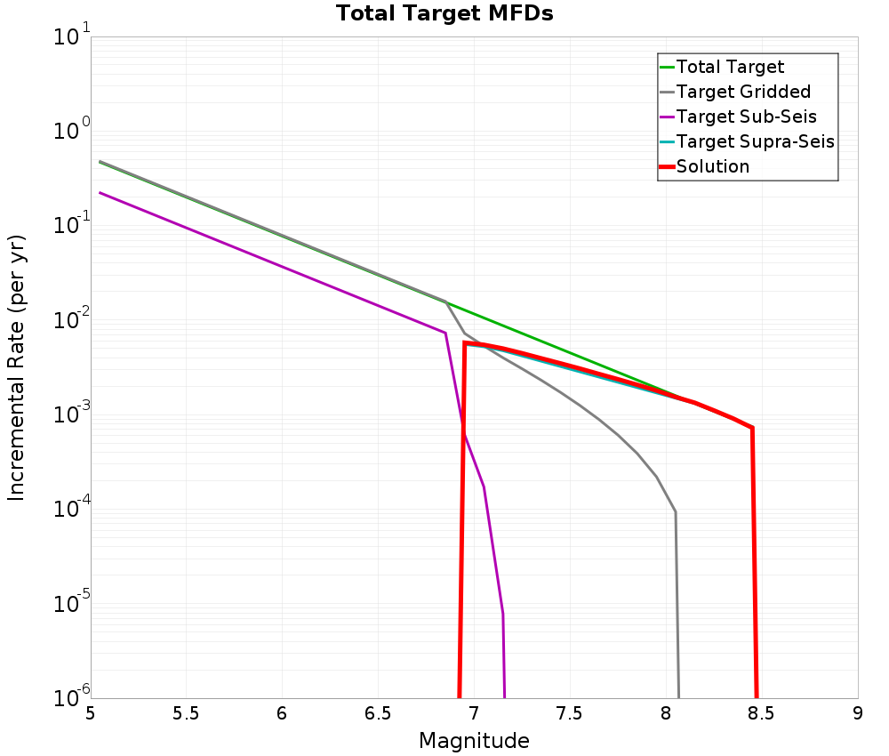 | 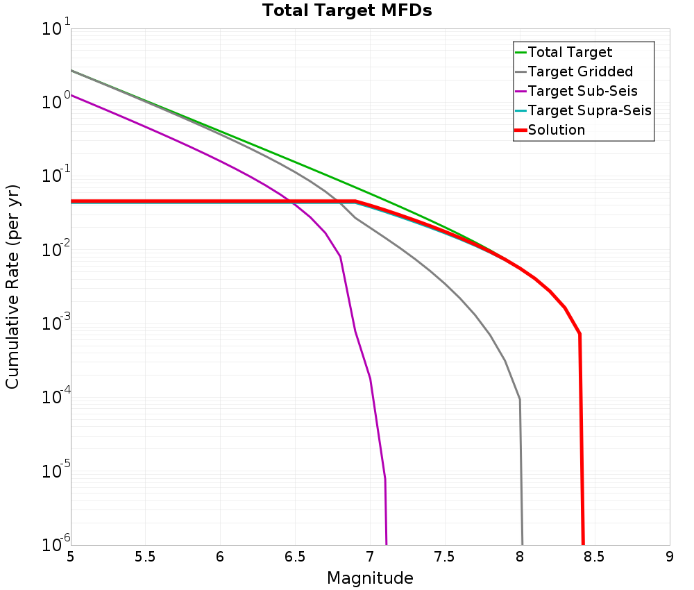 |
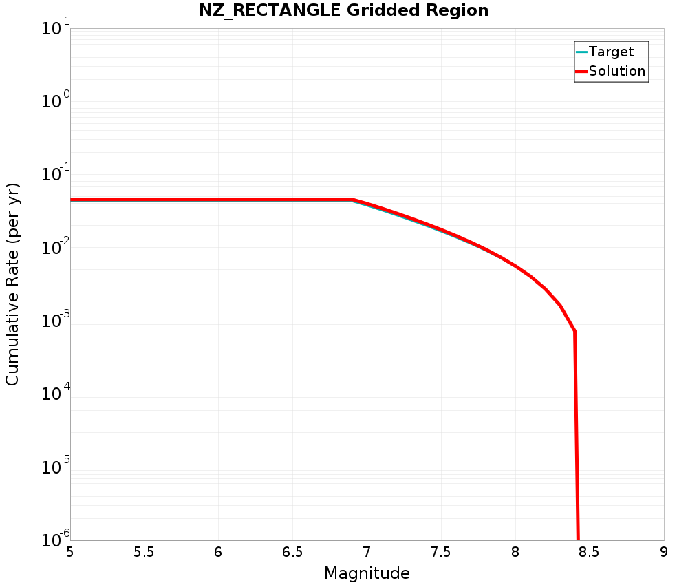
NZ_RECTANGLE Gridded Region
| Incremental MFDs | Cumulative MFDs |
|---|---|
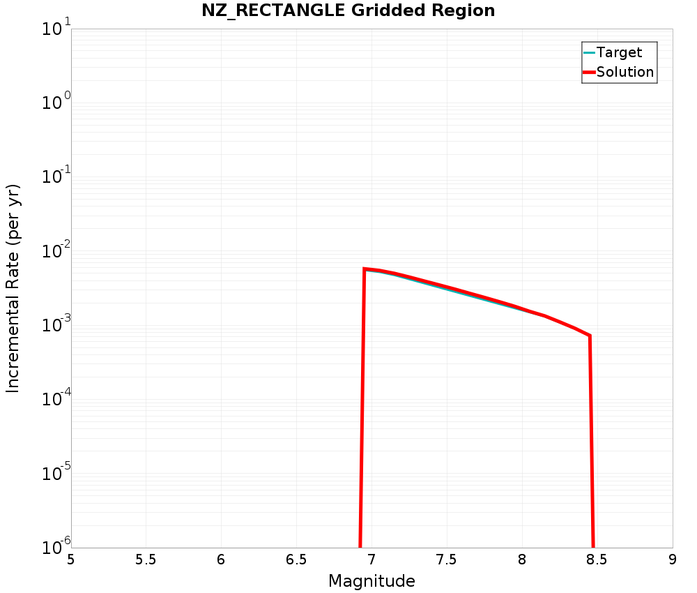 |  |
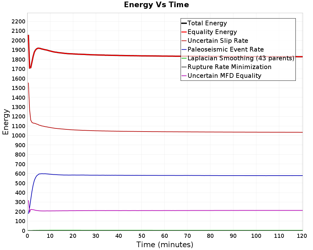
Simulated Annealing Energy
| Iterations | 2,965,778,367 |
|---|---|
| Time | 2 hours 0.4 mins |
| Iterations Per Sec. | 410,690 |
| Perturbations | 16,632,983 |
| # Worse Pertubations Kept | 978,601 |
| Iterations Per Perturb. | 178 |
| Total Energy | 1827.9026 |
Final Energies
| Energy Type | Final Energy (2 hours 0.4 mins) | % of Total | After 30 mins | 1 hour | 1 hour 30 mins |
|---|---|---|---|---|---|
| Total Energy | 1827.9026 | 1847.1301 | 1834.4042 | 1829.81 | |
| Equality Energy | 1827.9026 | 100.00% | 1847.1301 | 1834.4042 | 1829.81 |
| Entropy Energy | 0.0 | 0.00% | 0.0 | 0.0 | 0.0 |
| Inequality Energy | 0.0 | 0.00% | 0.0 | 0.0 | 0.0 |
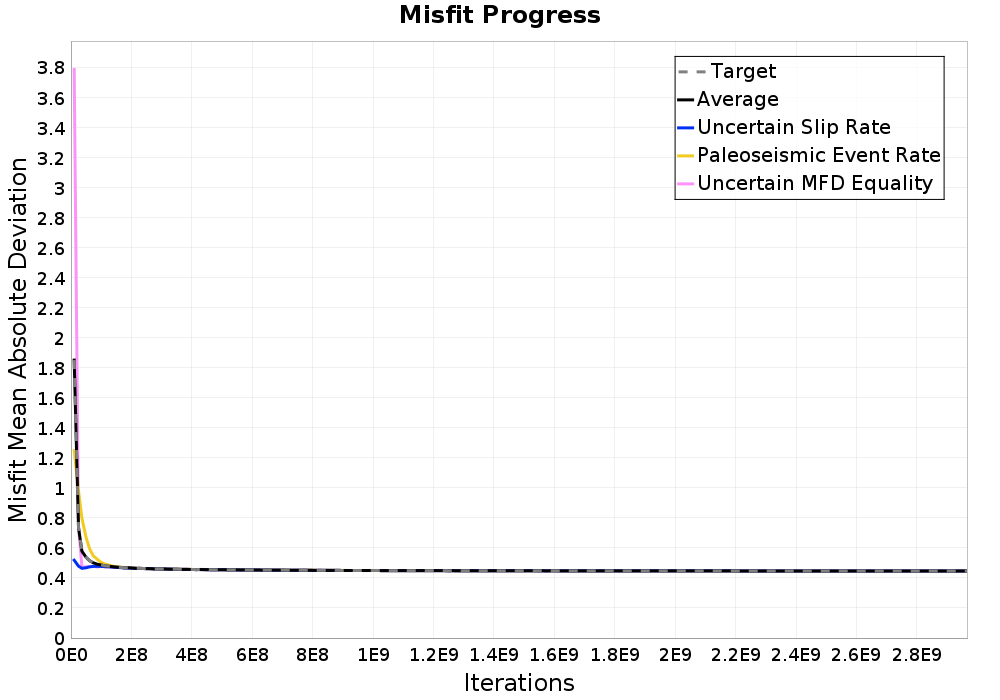
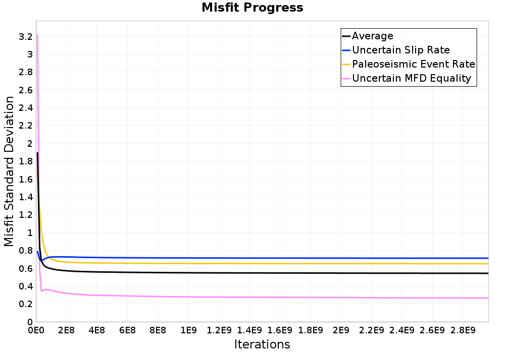
| Uncertain Slip Rate | 1033.4362 | 56.54% | 1049.5905 | 1039.4393 | 1035.5895 |
| Paleoseismic Event Rate | 578.29047 | 31.64% | 582.6948 | 580.07306 | 578.3115 |
| Laplacian Smoothing (43 parents) | 3.3047438 | 0.18% | 3.7503805 | 3.461125 | 3.3230734 |
| Rupture Rate Minimization | 0.15222913 | 0.01% | 0.17673863 | 0.15898134 | 0.15387289 |
| Uncertain MFD Equality | 212.71893 | 11.64% | 210.91772 | 211.2716 | 212.432 |
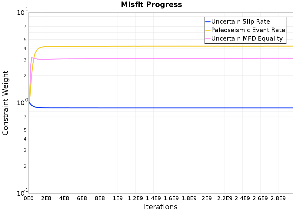
Energy Progress
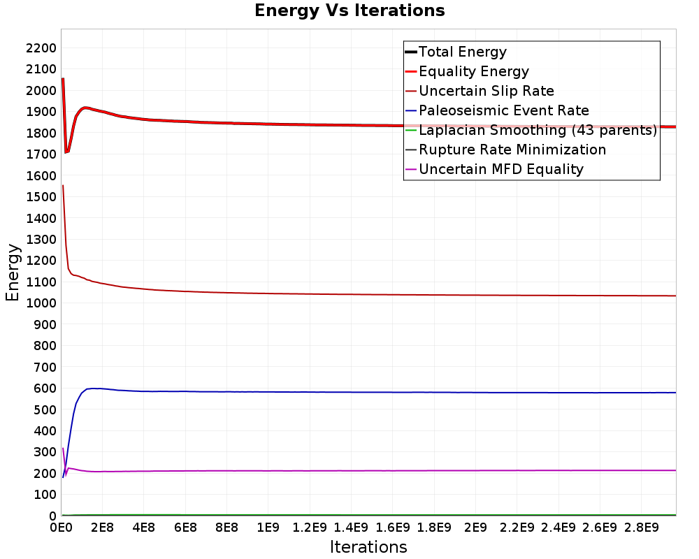
Constraint Misfit Progress
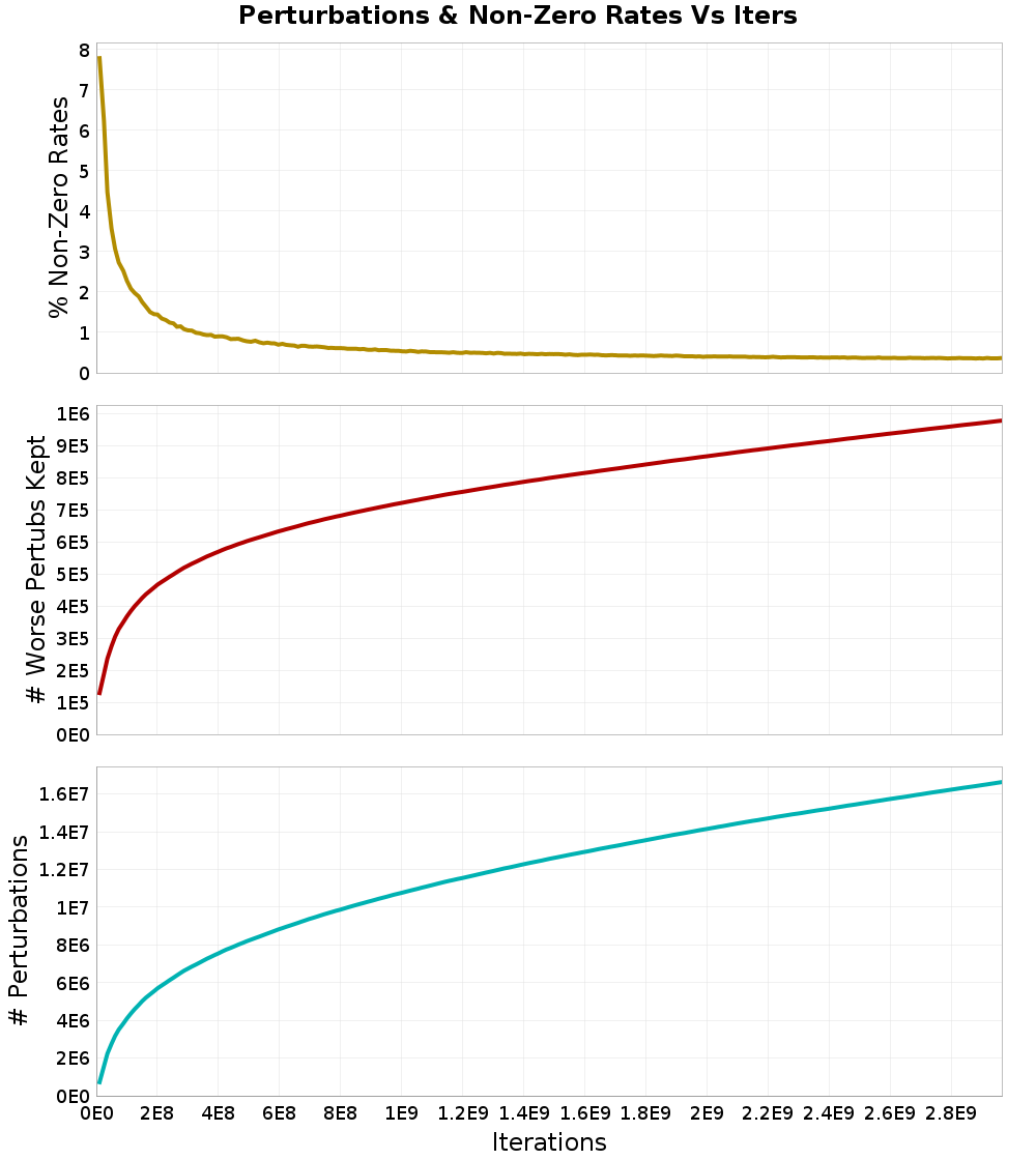
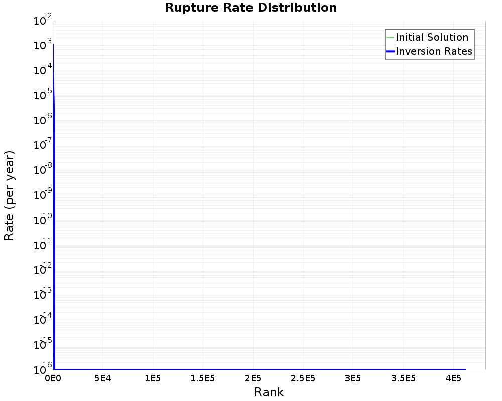
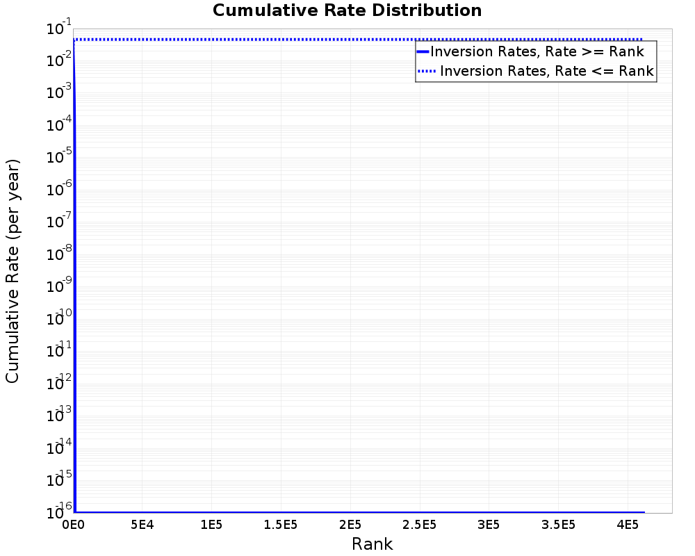
Rupture Rate Distribution
| Non-zero ruptures | 1,509 (0.37%) |
|---|---|
| Avg. # perturbations per rupture | 40.442978 |
| Avg. # perturbations per non-zero rupture | 11022.5205 |
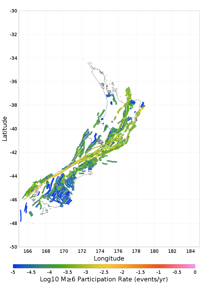
Participation Rates
Supra-Seismogenic | Range: M≤6 |
|---|---|
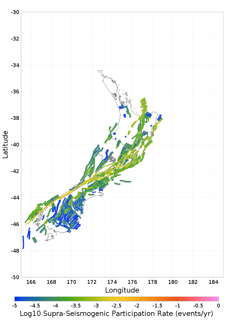 |  |
| Download GeoJSON | Download GeoJSON |
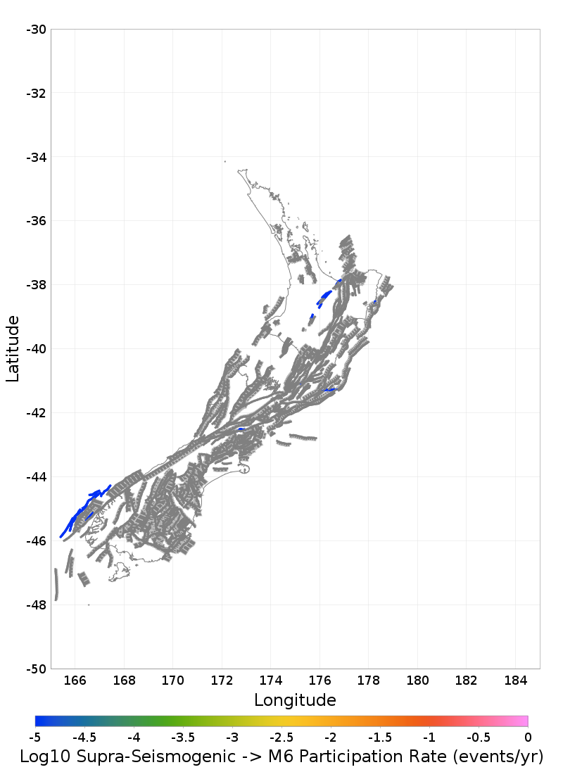
M≥6 | Range: M∈[6, 7] |
 | 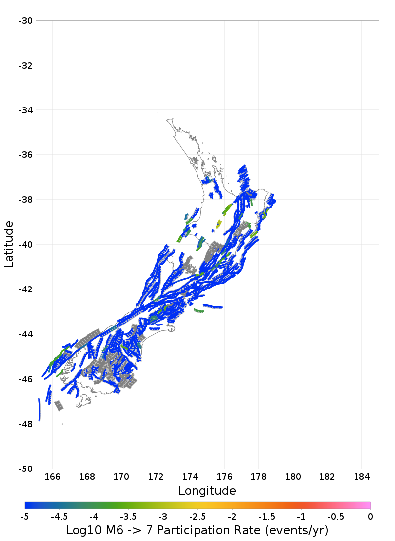 |
| Download GeoJSON | Download GeoJSON |
M≥7 | Range: M∈[7, 8] |
 | 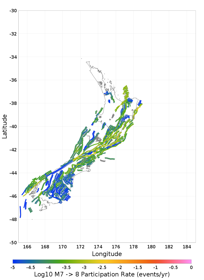 |
| Download GeoJSON | Download GeoJSON |
M≥8 | |
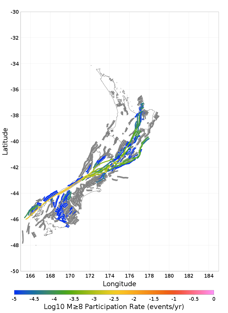 | |
| Download GeoJSON |
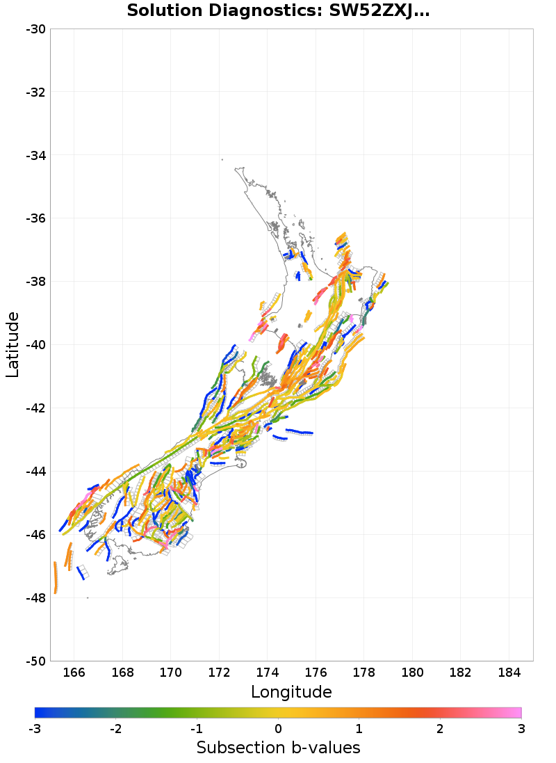
Section b-values
Subsection b-values
These plots estimate a Gutenberg-Richter b-value for each subsection and parent section nucleation MFD. This is a rough approximation, and is intended primarily for model comparisons.
Download b-value CSV file: sect_b_values.csv
| b-Value Distribution | b-Value Rate-Dependence |
|---|---|
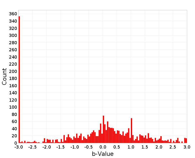 | 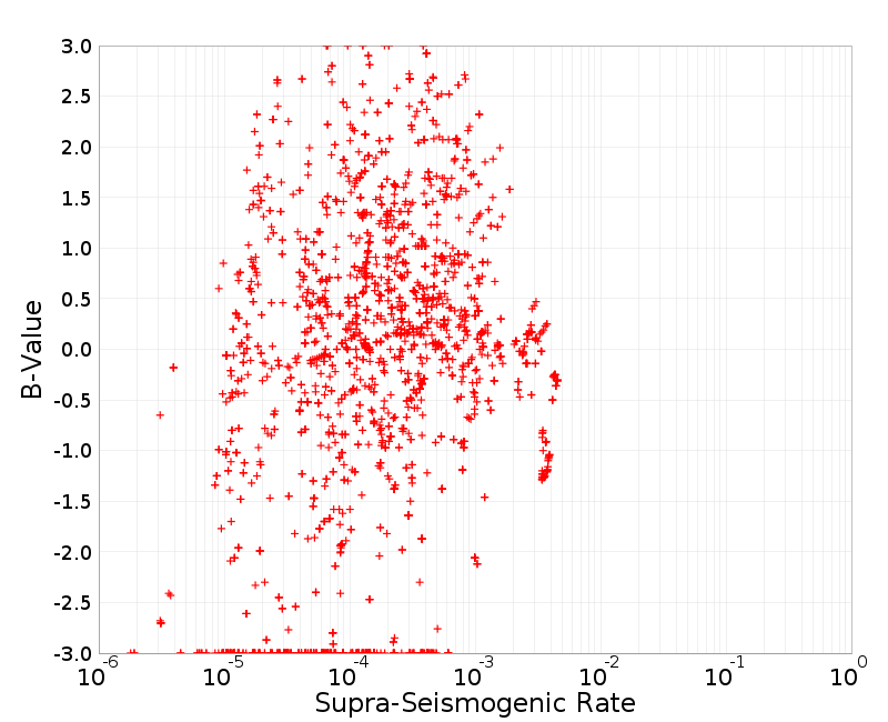 |
Parent Section b-values
Download b-value CSV file: parent_sect_b_values.csv
| b-Value Distribution | b-Value Rate-Dependence |
|---|---|
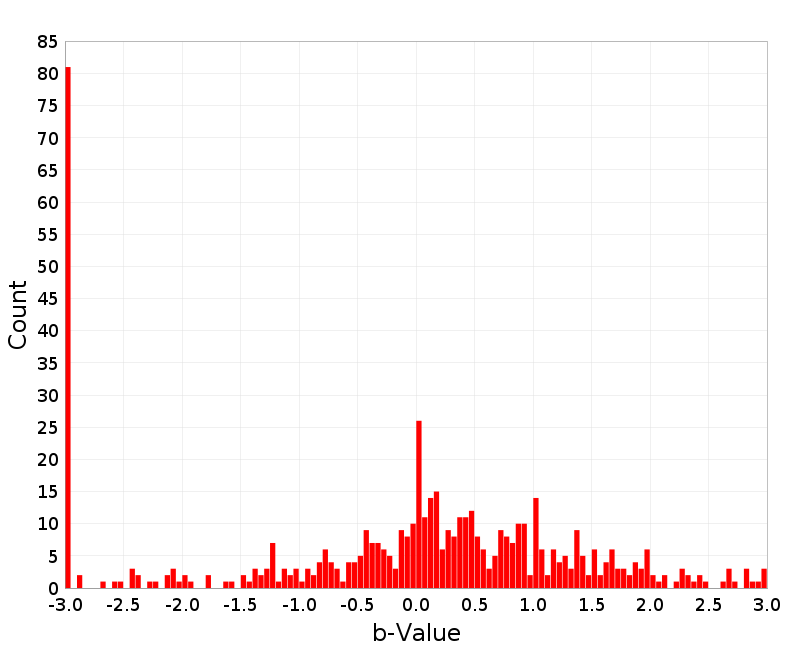 | 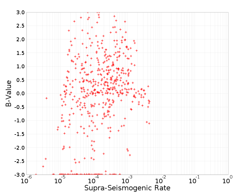 |
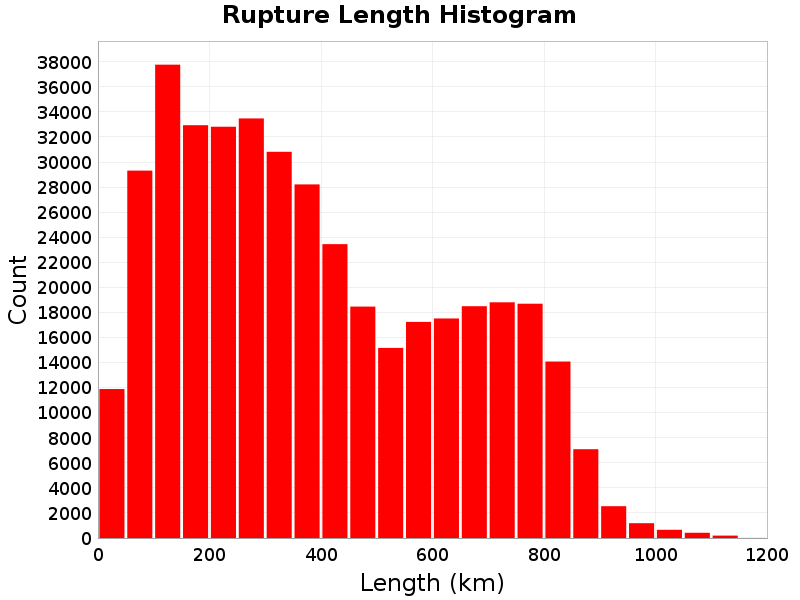
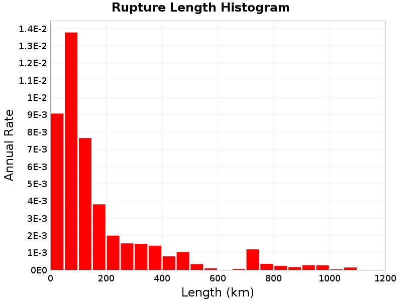
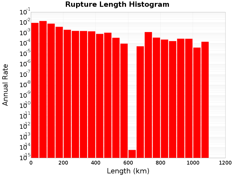
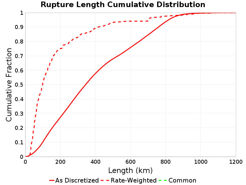
Rupture Scalar Histograms
Rupture Length
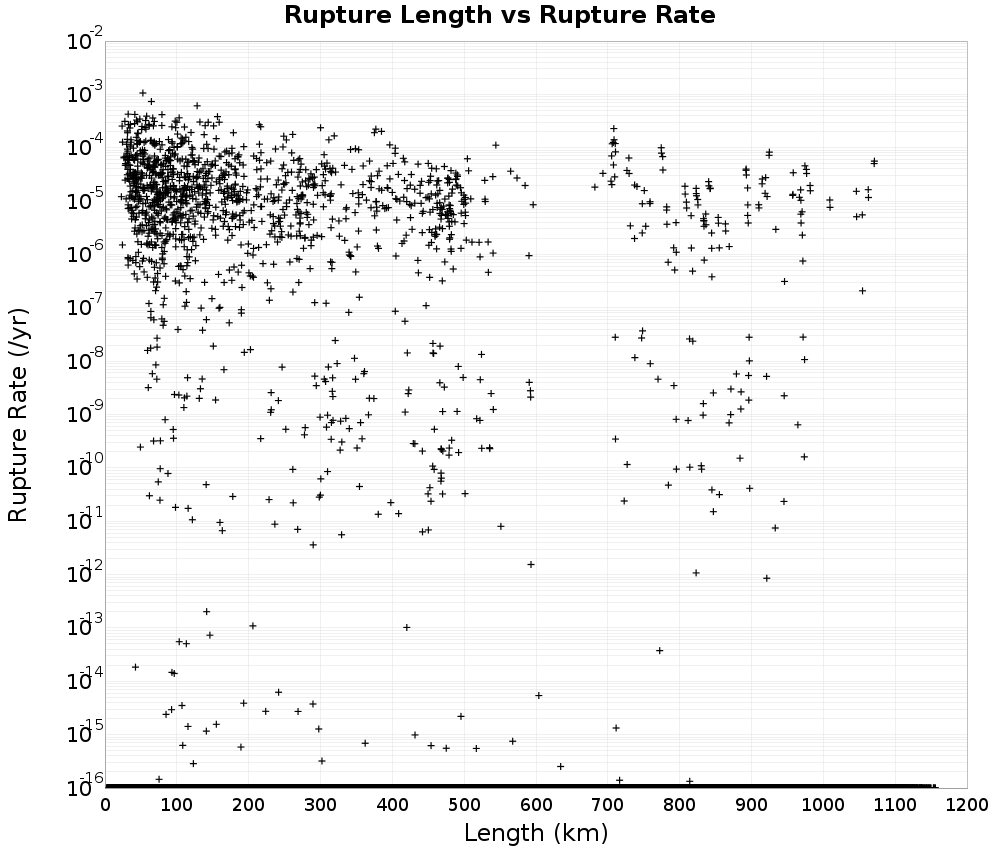
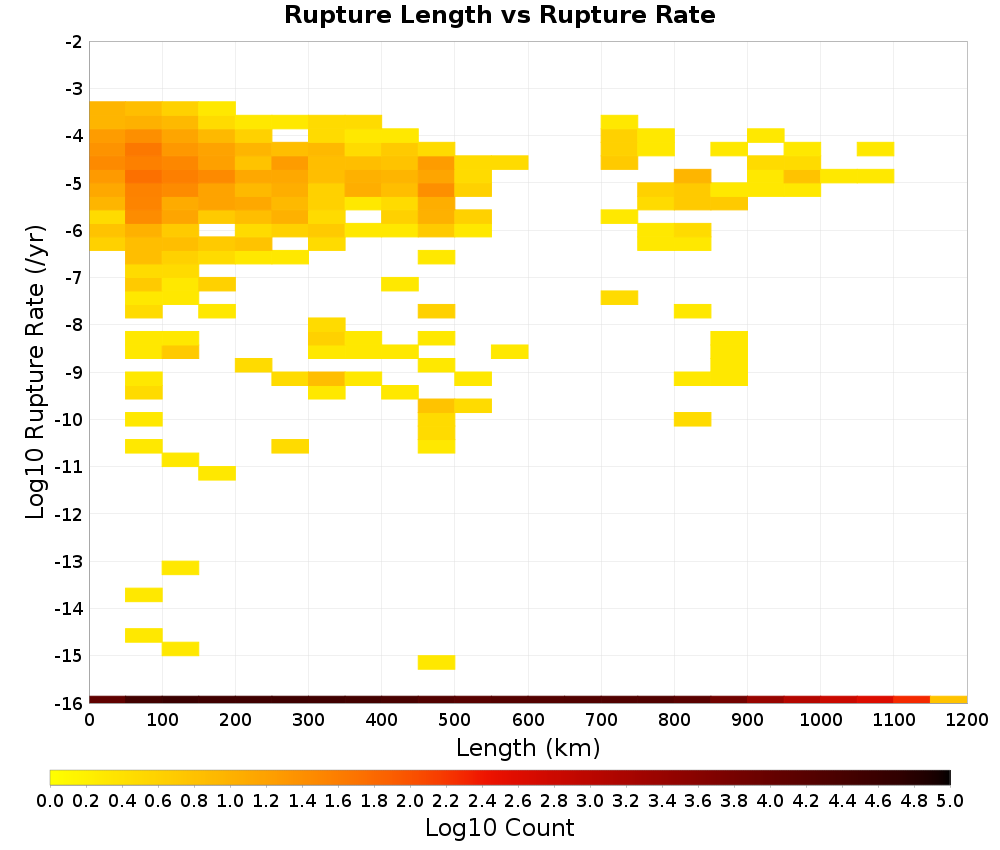
Total length (km) of the rupture, not including jumps or gaps.
 |
|---|
 |
 |
 |
Rupture Length vs Rupture Rate
 |  |
|---|
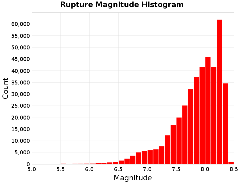
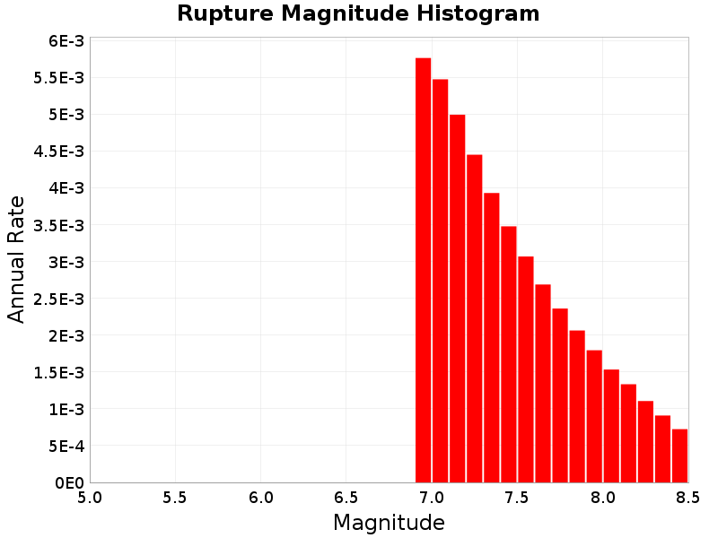
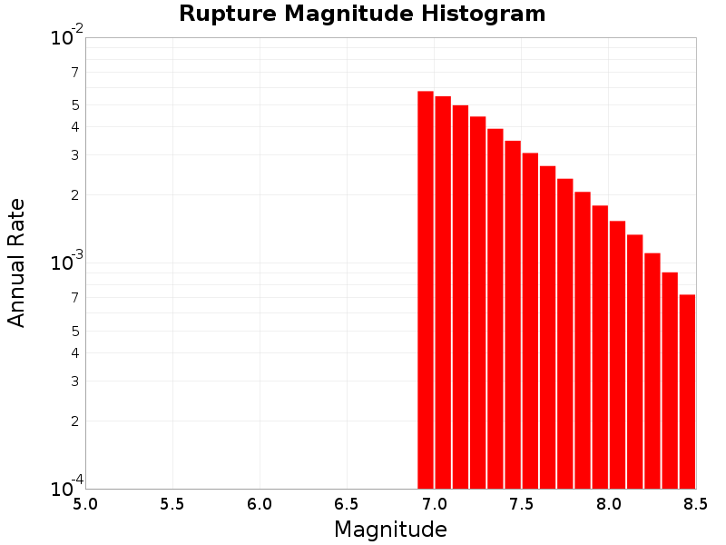
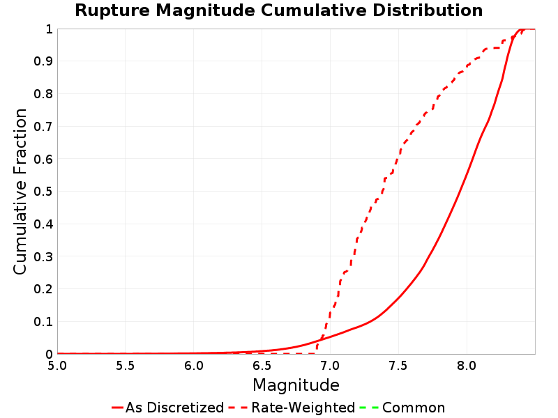
Rupture Magnitude
Magnitude of the rupture.
 |
|---|
 |
 |
 |
Rupture Magnitude vs Rupture Rate
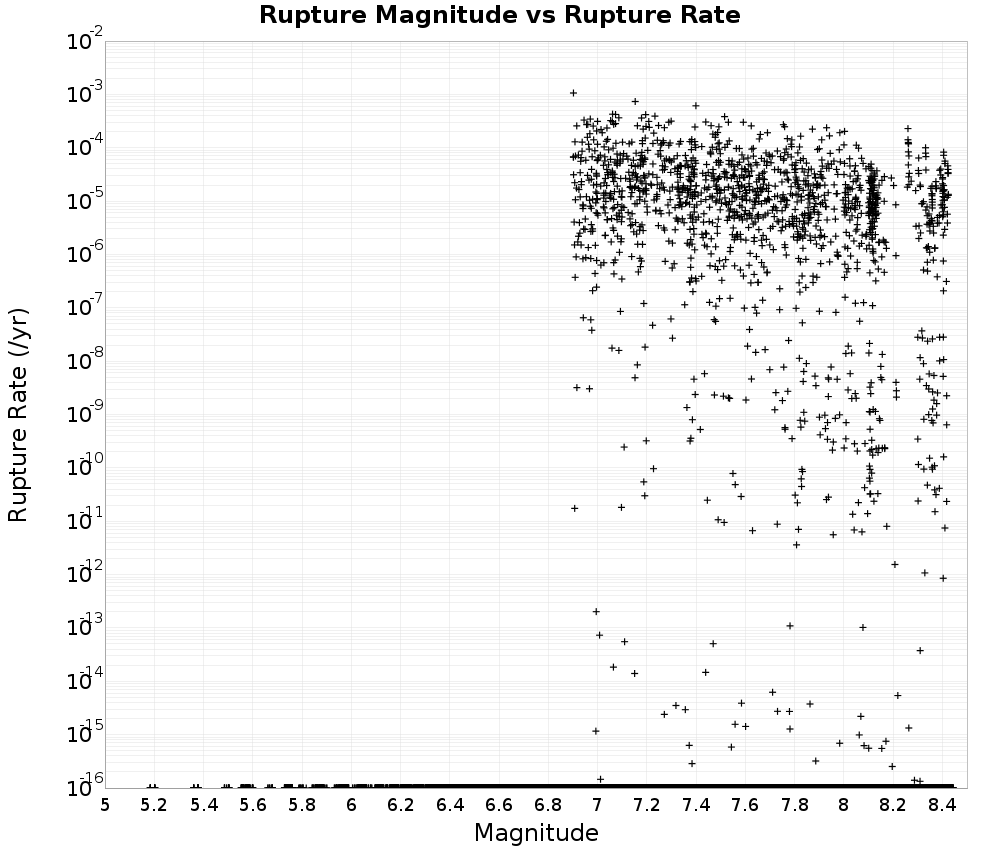 | 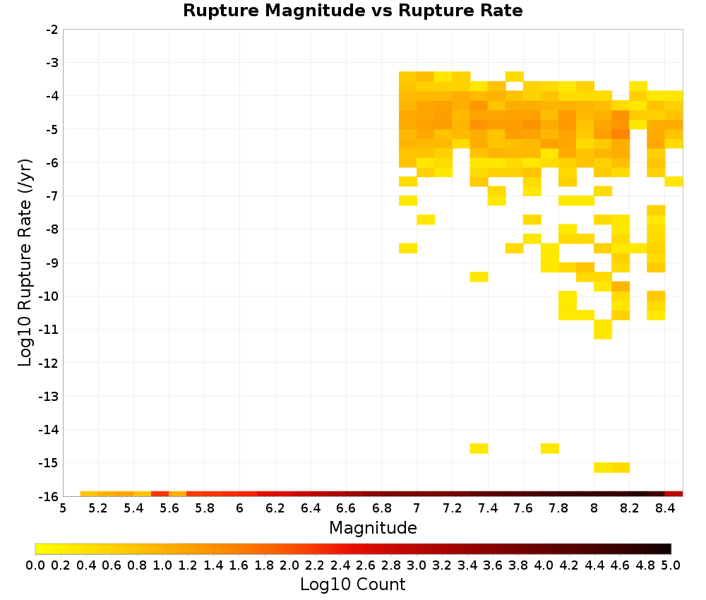 |
|---|
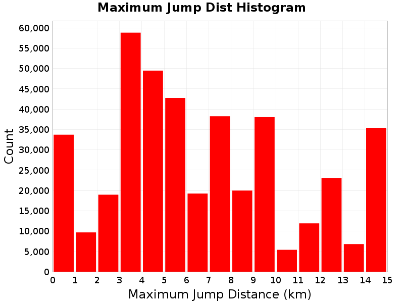
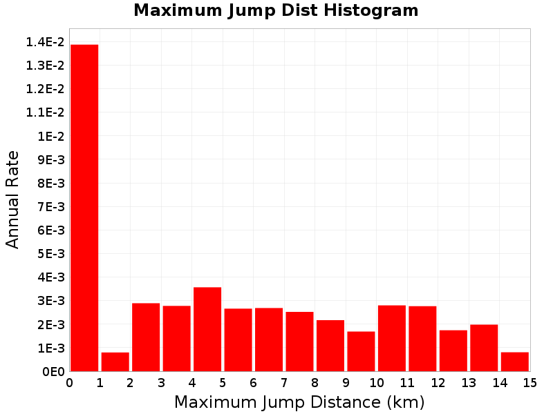
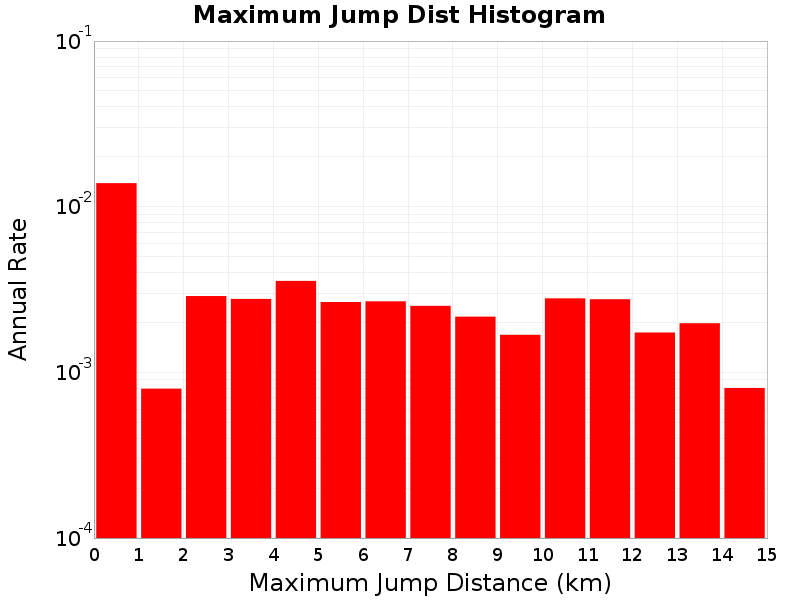
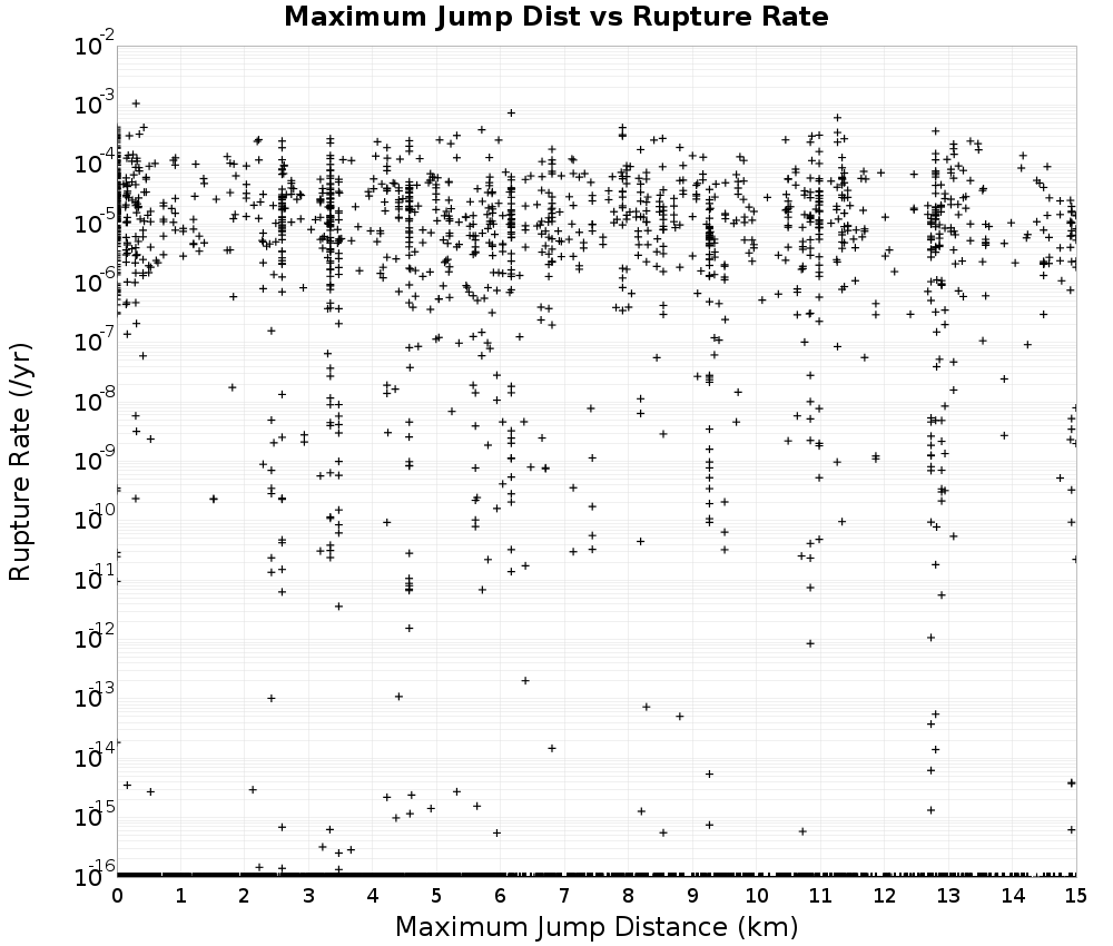
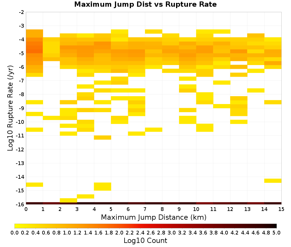
Maximum Jump Dist
The maximum jump distance in the rupture.
 |
|---|
 |
 |
 |
Maximum Jump Dist vs Rupture Rate
 |  |
|---|
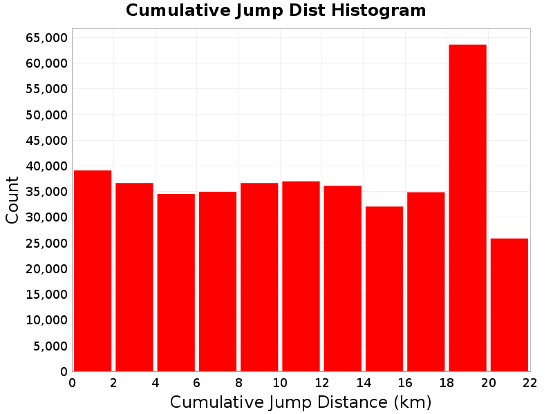
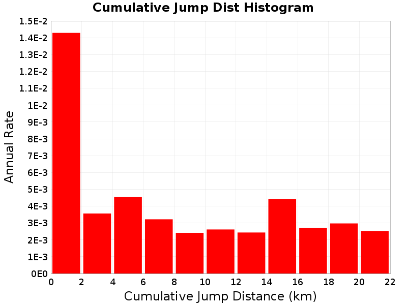
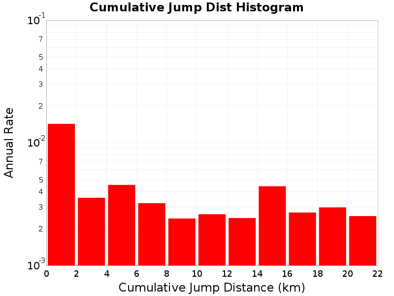
Cumulative Jump Dist
The total cumulative jump distance summed over all jumps in the rupture.
 |
|---|
 |
 |
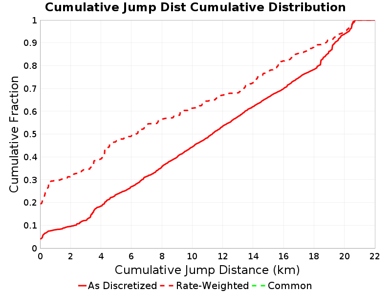 |
Cumulative Jump Dist vs Rupture Rate
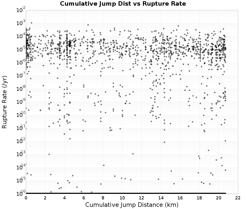 | 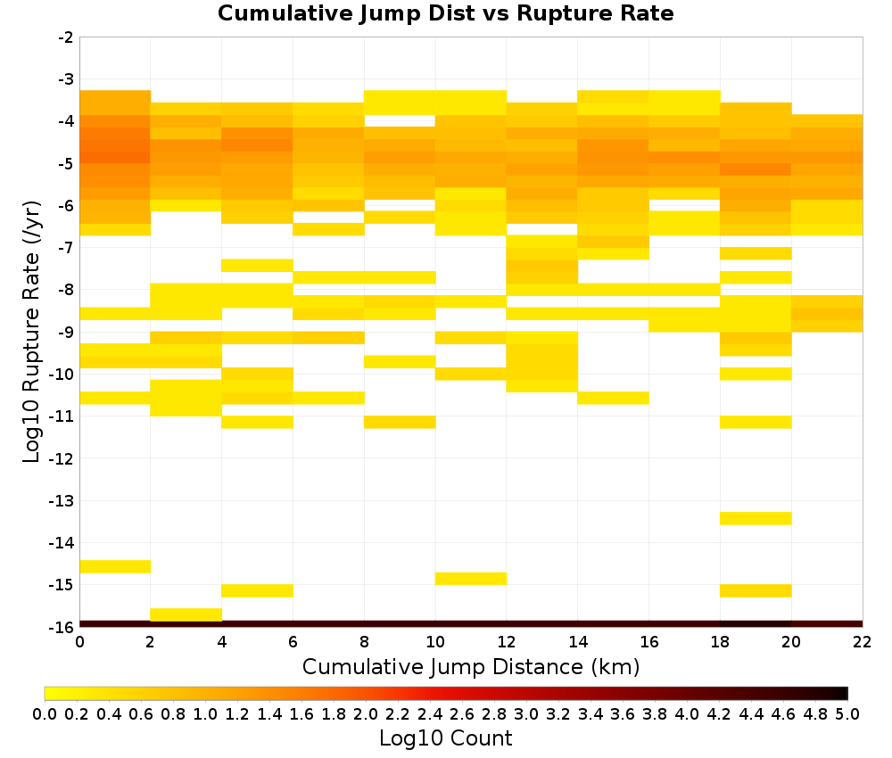 |
|---|
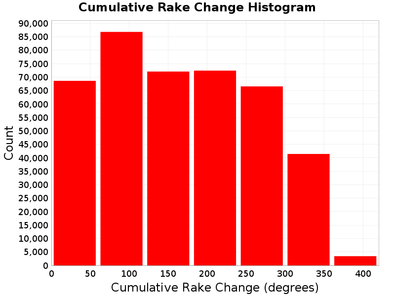
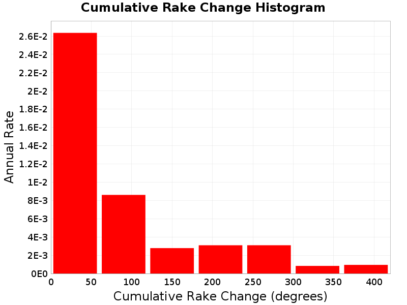
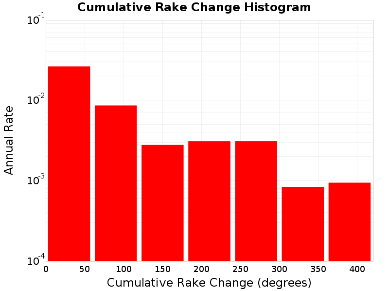
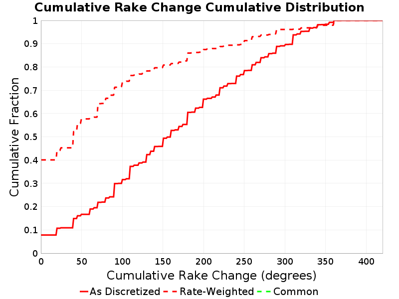
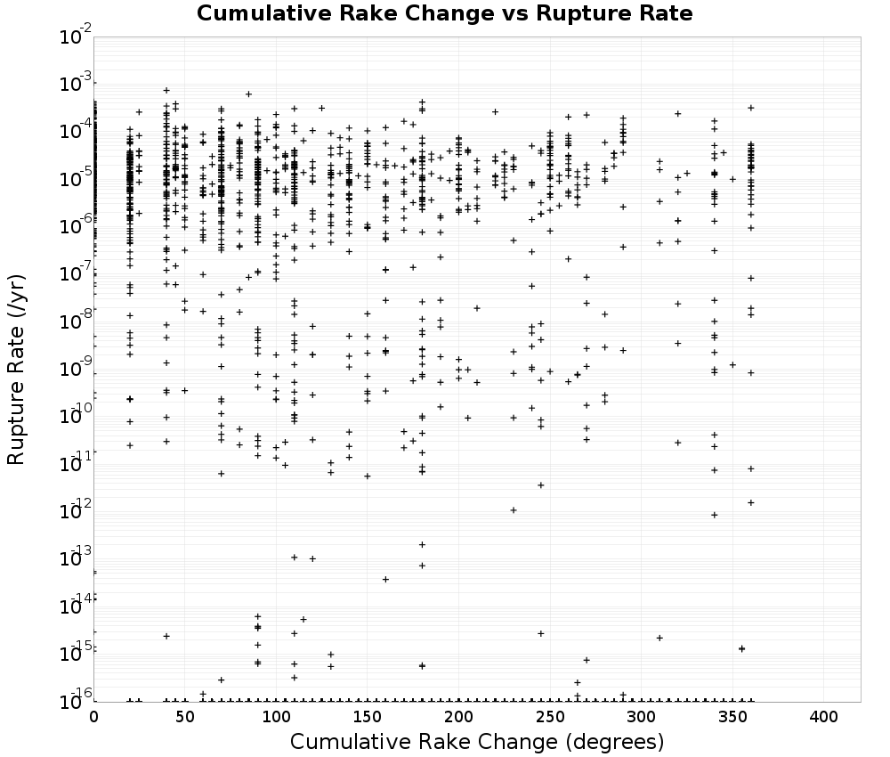
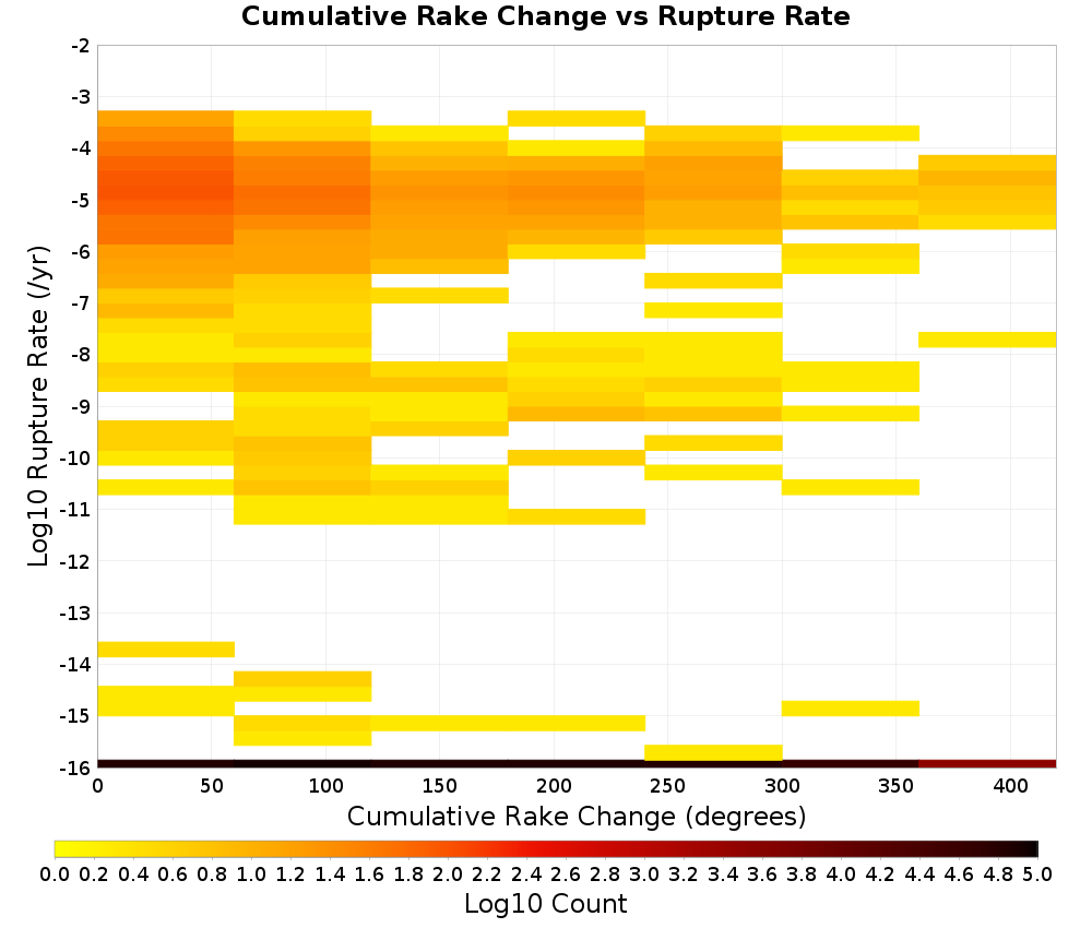
Cumulative Rake Change
Cumulative rake change for this rupture.
 |
|---|
 |
 |
 |
Cumulative Rake Change vs Rupture Rate
 |  |
|---|
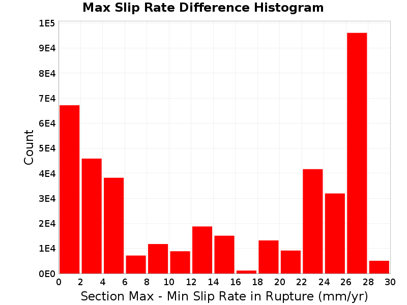
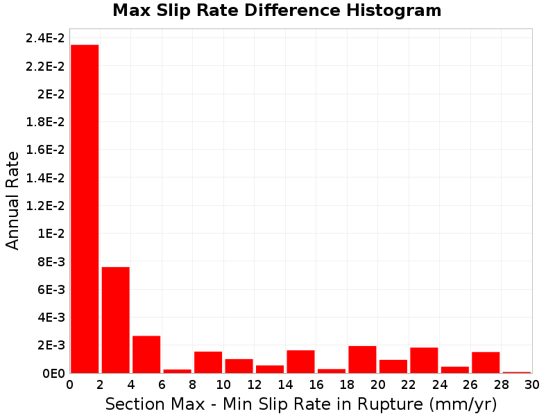
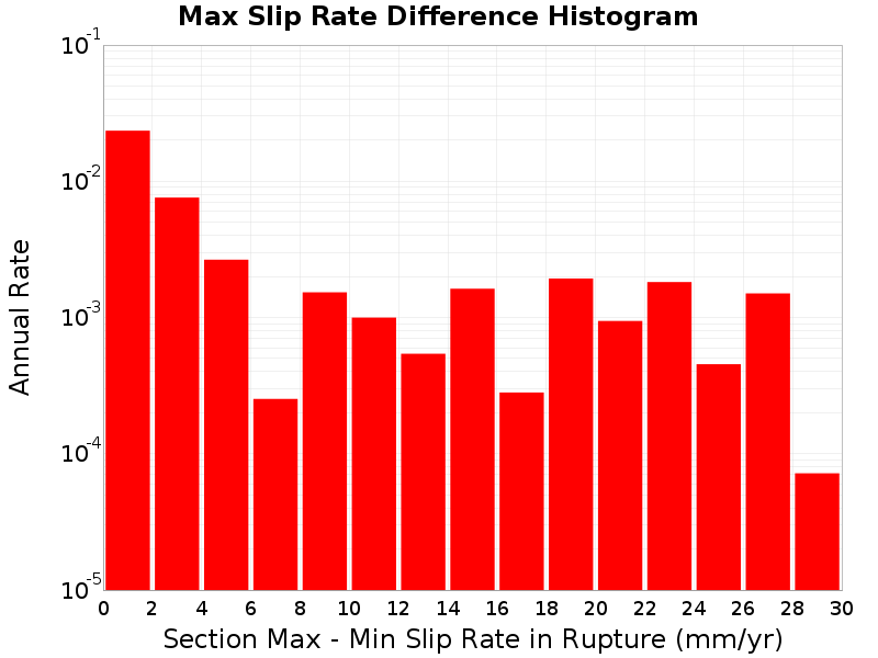
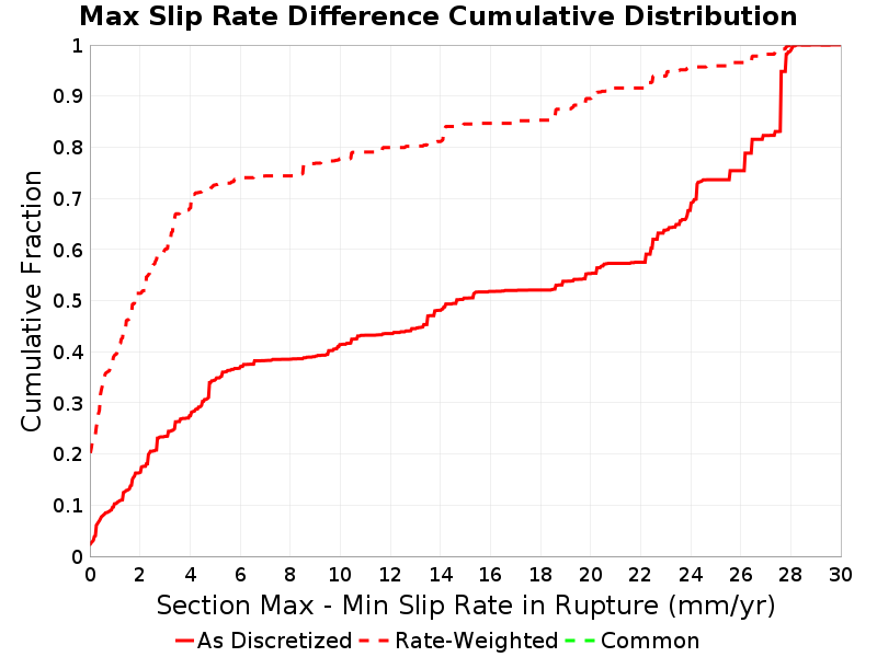
Max Slip Rate Difference
The difference between the slip rate of the sections with the highest and lowest slip rate in the rupture.
 |
|---|
 |
 |
 |
Max Slip Rate Difference vs Rupture Rate
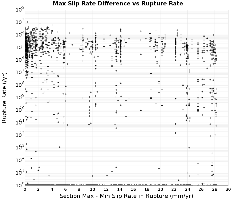 | 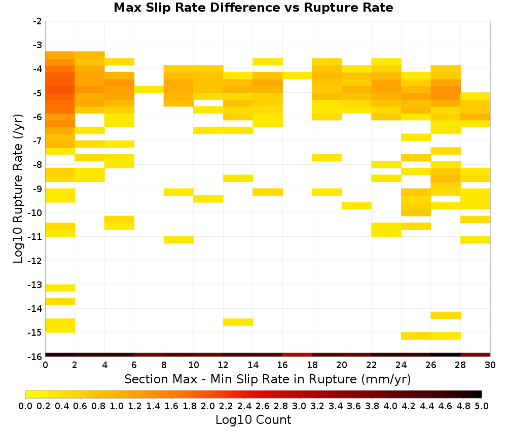 |
|---|
Attached Modules
List of all modules that have been attached to this Solution.
Note: Modules classes in the standard modules package, org.opensha.sha.earthquake.faultSysSolution.modules, have been shortened to omit the package name.
Rupture Set Modules
| Name | Implementing Class |
|---|---|
| Logic Tree Branch | nz.cri.gns.NZSHM22.opensha.enumTreeBranches.NZSHM22_LogicTreeBranch |
| Named Faults | NamedFaults |
| Single-Strand Cluster Ruptures | ClusterRuptures$SingleStranded |
| Section Distance-Azimuth Calculator | org.opensha.sha.earthquake.faultSysSolution.ruptures.util.SectionDistanceAzimuthCalculator |
| Polygon Fault Grid Associations | PolygonFaultGridAssociations$Precomputed |
| Rupture Connection Search | org.opensha.sha.earthquake.faultSysSolution.ruptures.util.RuptureConnectionSearch |
| Section Slip Rates | SectSlipRates$Precomputed |
| Section Areas | SectAreas$Default |
| Inversion Target MFDs | InversionTargetMFDs$Precomputed |
| Precomputed Average Slips | AveSlipModule$Precomputed |
| Modified Section Minimum Magnitudes | ModSectMinMags$Precomputed |
| OpenSHA Build Information | BuildInfoModule |
| Uniform Slip Along Rupture | SlipAlongRuptureModel$Uniform |
| NZSHM22_TvzSections | nz.cri.gns.NZSHM22.opensha.inversion.NZSHM22_TvzSections |
| Paleoseismic Constraint Data | PaleoseismicConstraintData |
Solution Modules
| Name | Implementing Class |
|---|---|
| Annealing Progress | org.opensha.sha.earthquake.faultSysSolution.inversion.sa.completion.AnnealingProgress |
| Inversion Misfit Progress | InversionMisfitProgress |
| OpenSHA Build Information | BuildInfoModule |
| Sub-Seismogenic On-Fault MFDs | SubSeismoOnFaultMFDs |
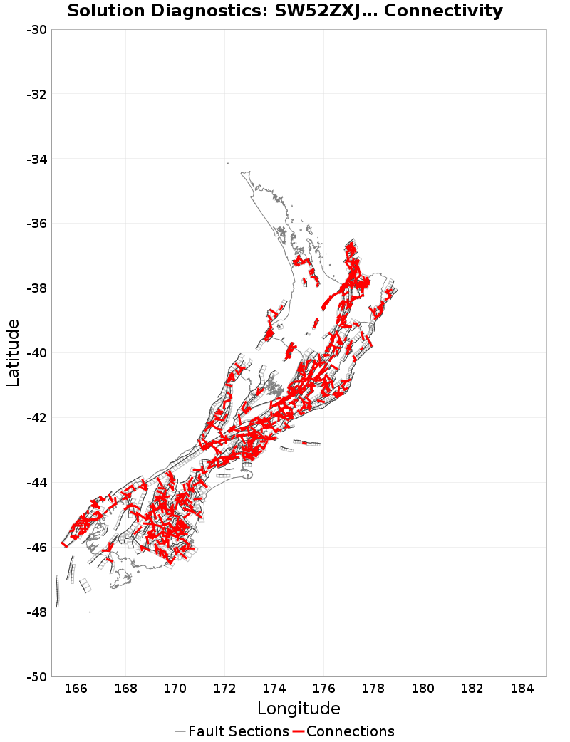
Fault Section Connections
 |
|---|
| Download GeoJSON |
 |
 |
 |
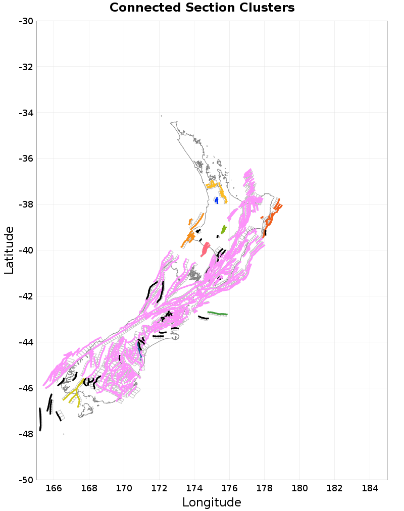
Connected Clusters
Connected clusters of fault sections, where all sections plotted in a given color connect with all other sections of the same color through ruptures. There may not be any single rupture that connects all such sections, but rather, chains of ruptures connect the sections. Only the first 10 clusters are plotted, with smaller clusters plotted in gray, and fully isolated faults plotted in black.
 |
|---|
| Download GeoJSON |
| Rank | Sections | Parent Sections | Ruptures |
|---|---|---|---|
| 1 | 1,925 (82.80%) | 455 (81.69%) | 407,110 (98.99%) |
| 2 | 61 (2.62%) | 8 (1.44%) | 2,151 (0.52%) |
| 3 | 50 (2.15%) | 13 (2.33%) | 483 (0.12%) |
| 4 | 40 (1.72%) | 15 (2.69%) | 684 (0.17%) |
| 5 | 38 (1.63%) | 15 (2.69%) | 211 (0.05%) |
| 6 | 26 (1.12%) | 5 (0.90%) | 128 (0.03%) |
| 7 | 13 (0.56%) | 3 (0.54%) | 58 (0.01%) |
| 8 | 12 (0.52%) | 2 (0.36%) | 55 (0.01%) |
| 9 | 8 (0.34%) | 2 (0.36%) | 17 (0.00%) |
| 10 | 4 (0.17%) | 2 (0.36%) | 3 (0.00%) |
| 37 isolated | 148 (6.37%) | 37 (6.64%) | 370 (0.09%) |
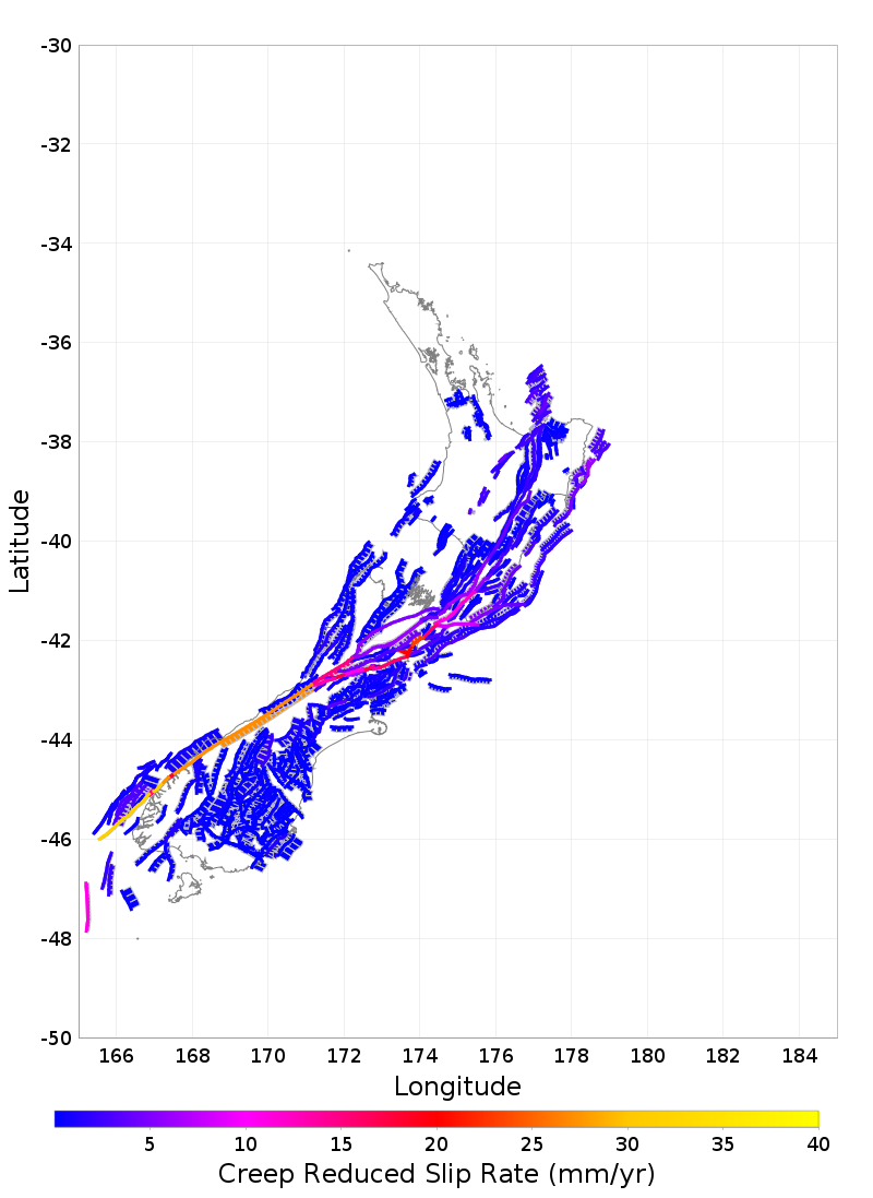
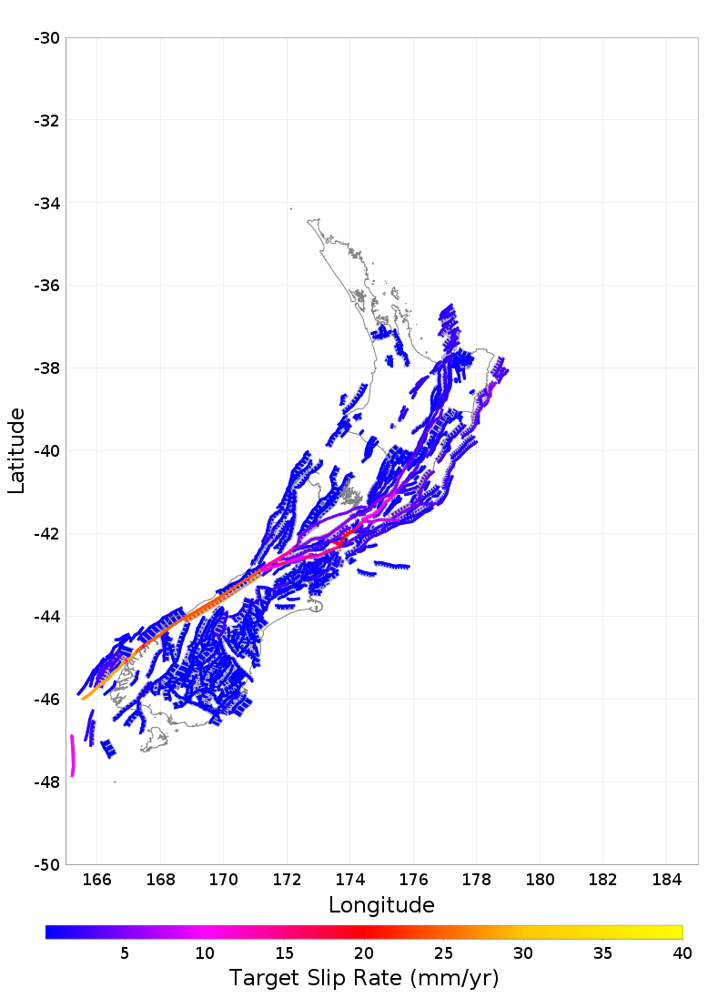
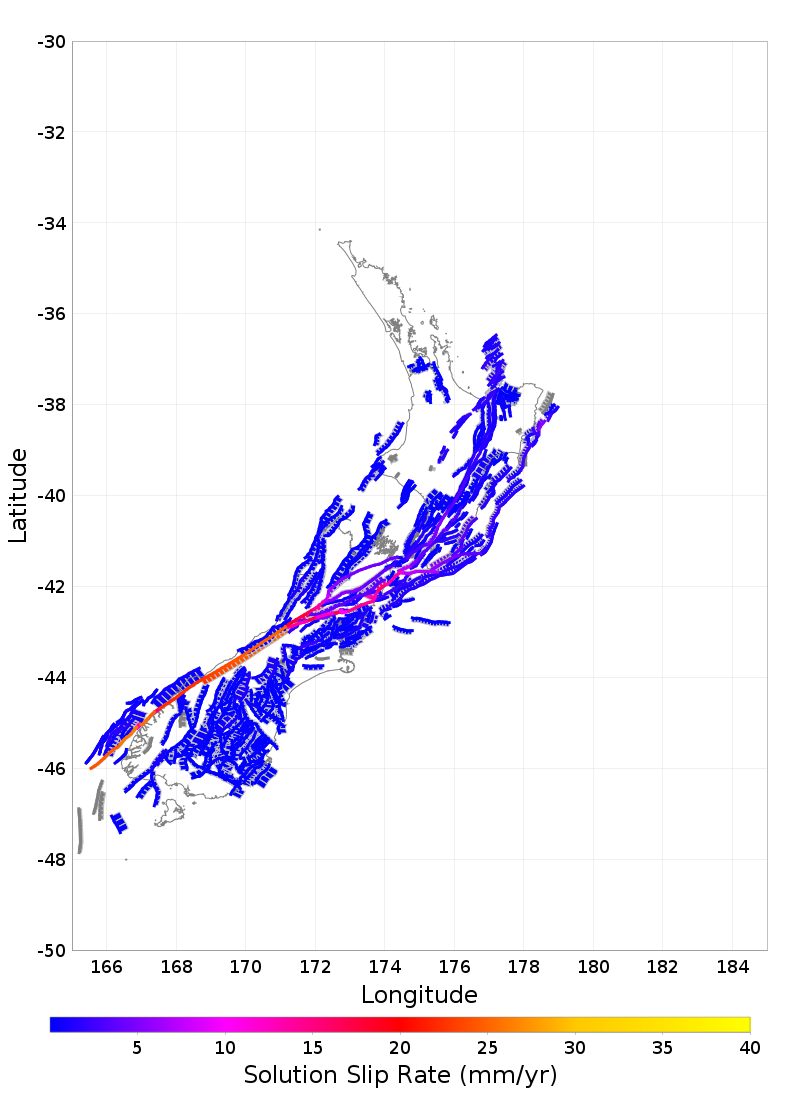
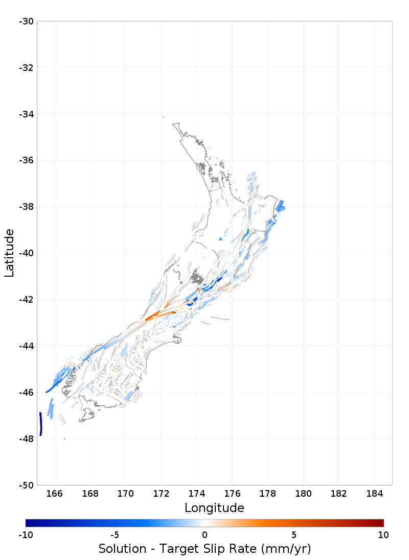
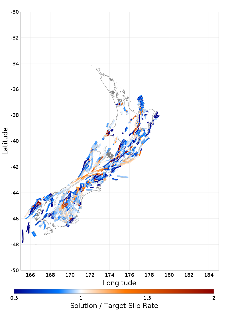
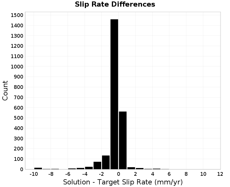
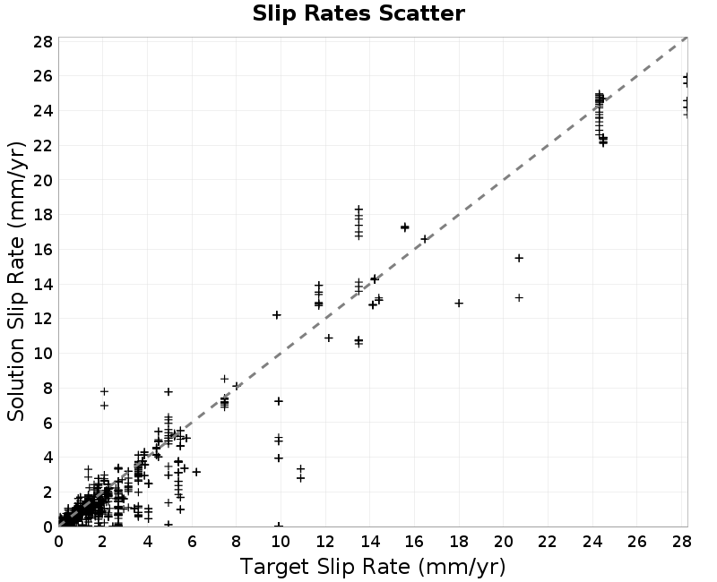
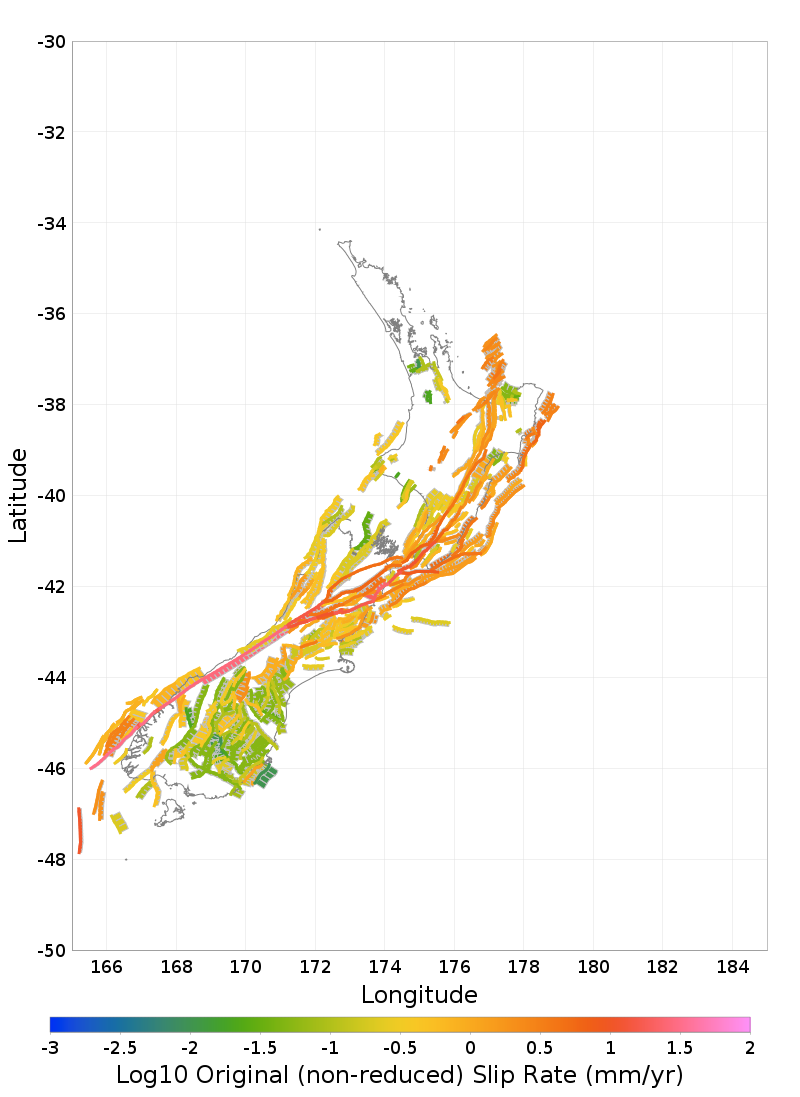
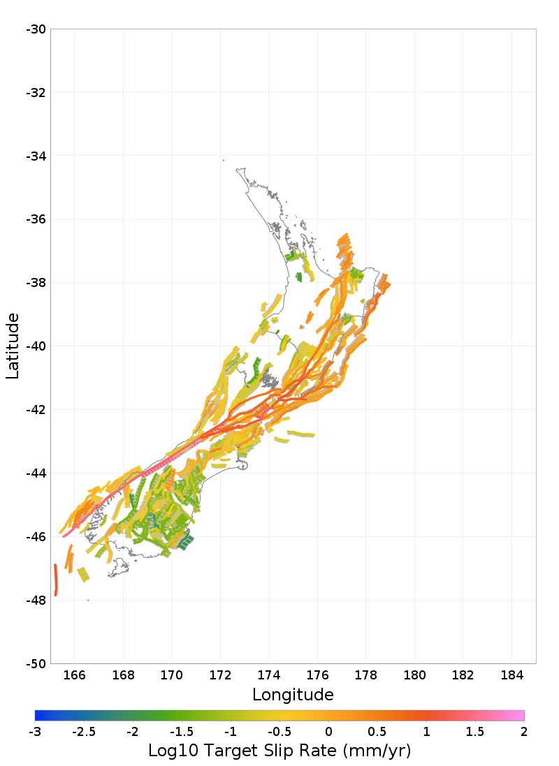
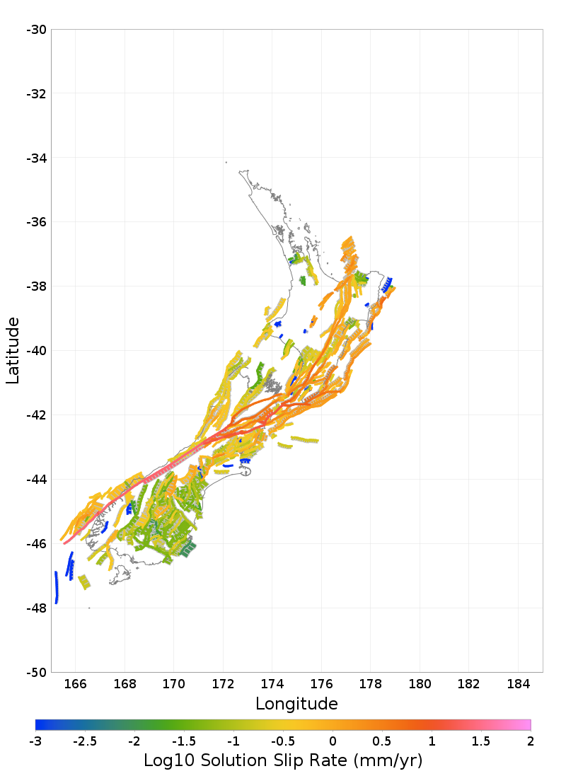
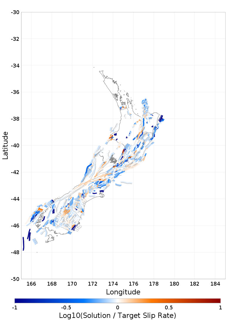
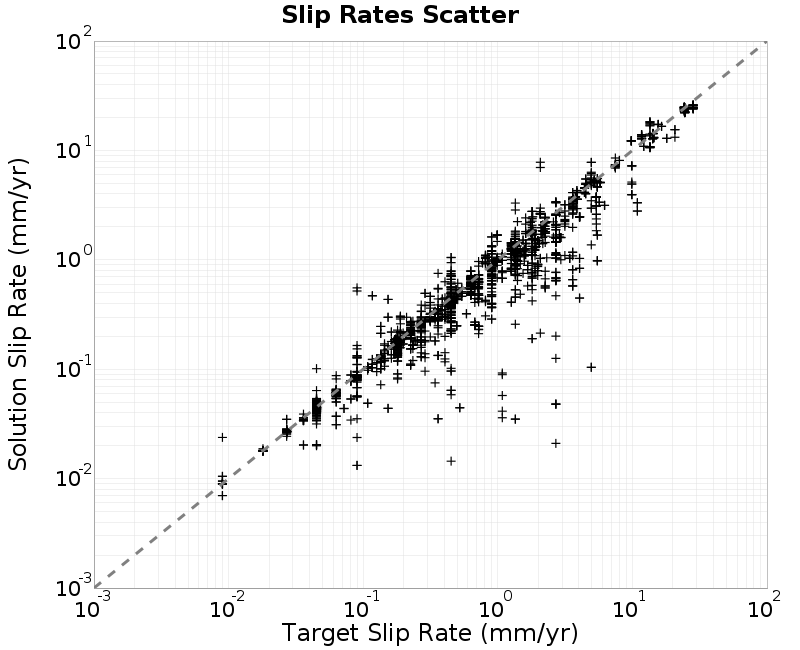
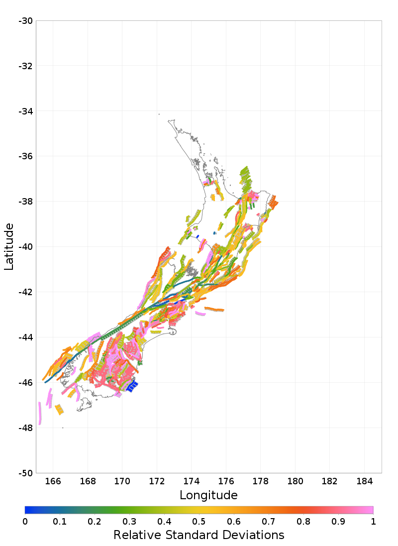
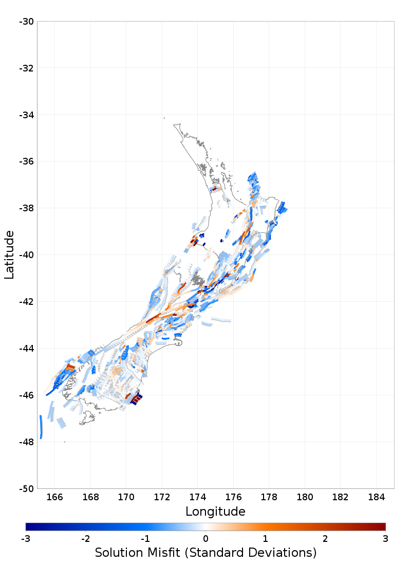
Slip Rates
Linear Slip Rate Plots
 |  |
|---|---|
| Download GeoJSON | Download GeoJSON |
 |  |
| Download GeoJSON | Download GeoJSON |
 |  |
| Download GeoJSON | Download GeoJSON |
 |  |
Log10 Slip Rate Plots
 |  |
|---|---|
| Download GeoJSON | Download GeoJSON |
 |  |
| Download GeoJSON | Download GeoJSON |
 |  |
| Download GeoJSON |
Slip Rate Std Dev Plots
 |  |
|---|---|
| Download GeoJSON | Download GeoJSON |
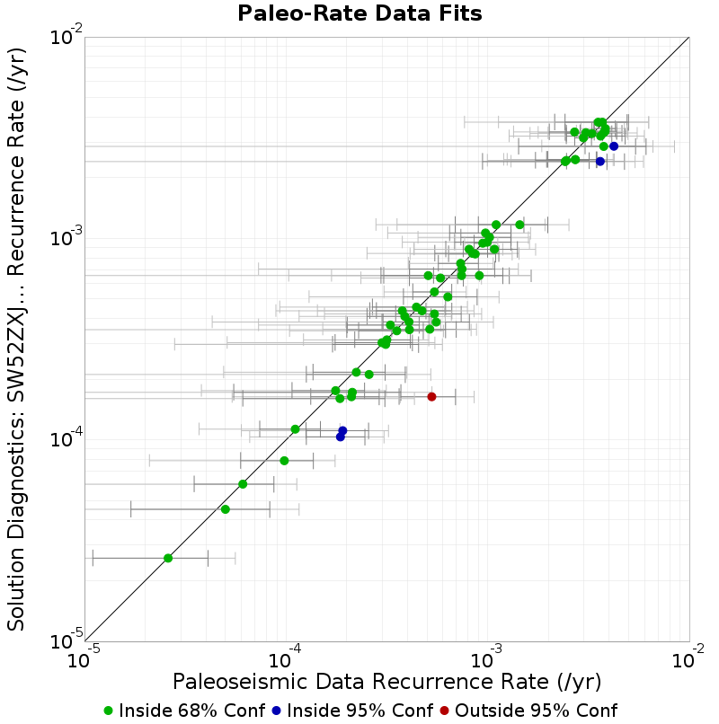
Paleoseismic Data Comparison
 |
|---|
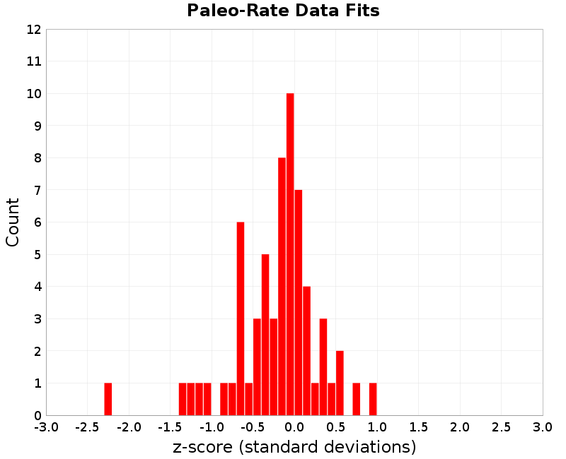 |
Paleo data comparison table. For the solution column, text is bold if within 68% bounds, italicized if within 95% bounds, and otherwise plain text. Download CSV here.
| Site Name | Mapped Subsection ID | Mapped Parent Section | Constraint Mean Rate | 68% Bounds | Constraint 95% Bounds | Std. Dev | Solution Rate | z-score |
|---|---|---|---|---|---|---|---|---|
| Alpine George to Jacksons - Hokuri Creek sections | 34 | Alpine: George to Jacksons | 0.002985 | [0.0027, 0.00327] | [0.002415, 0.003555] | 2.85E-4 | 0.0031529793 | 0.5894009 |
| Akatore - Big Creek trench | 8 | Akatore | 2.6E-5 | [1.1E-5, 4.1E-5] | [-4.0E-6, 5.6E-5] | 1.5E-5 | 2.5866646E-5 | -0.008890236 |
| Alpine George to Jacksons - Lake Ellery cores | 40 | Alpine: George to Jacksons | 0.003752 | [0.002872, 0.004632] | [0.001992, 0.005512] | 8.8E-4 | 0.0033327353 | -0.47643718 |
| Alpine George to Jacksons - John O'Groats Wetland | 32 | Alpine: George to Jacksons | 0.003291 | [0.002456, 0.004126] | [0.001621, 0.004961] | 8.35E-4 | 0.003312512 | 0.025763014 |
| Alpine Jacksons to Kaniere - Lake Paringa cores | 46 | Alpine: Jacksons to Kaniere | 0.003831 | [0.003366, 0.004296] | [0.002901, 0.004761] | 4.65E-4 | 0.0035067608 | -0.69728875 |
| Alpine Jacksons to Kaniere - Lake Mapourika cores | 54 | Alpine: Jacksons to Kaniere | 0.003067 | [0.002423, 0.003711] | [0.001779, 0.004355] | 6.44E-4 | 0.0033461372 | 0.43344304 |
| Alpine Jacksons to Kaniere - Staples 2 trench | 61 | Alpine: Jacksons to Kaniere | 0.00353 | [0.0021485, 0.0049115] | [7.67E-4, 0.006293] | 0.0013815 | 0.0037693756 | 0.17327227 |
| Alpine Jacksons to Kaniere - Staples 3 trench | 61 | Alpine: Jacksons to Kaniere | 0.003706 | [0.0024185, 0.0049935] | [0.001131, 0.006281] | 0.0012875 | 0.0037693756 | 0.049223788 |
| Alpine Jacksons to Kaniere - Haast South trench | 43 | Alpine: Jacksons to Kaniere | 0.002697 | [0.00202, 0.003374] | [0.001343, 0.004051] | 6.77E-4 | 0.003371534 | 0.99635744 |
| Alpine Kaniere to Springs Junction - Lake Kaniere cores | 71 | Alpine: Kaniere to Springs Junction | 0.003825 | [0.003289, 0.004361] | [0.002753, 0.004897] | 5.36E-4 | 0.003398803 | -0.7951436 |
| Alpine Kaniere to Springs Junction - Lake Brunner cores | 68 | Alpine: Kaniere to Springs Junction | 0.003629 | [0.002453, 0.004805] | [0.001277, 0.005981] | 0.001176 | 0.003216046 | -0.35115138 |
| Alpine Springs Junction to Tophouse - Maruia Trench-1 | 62 | Alpine: Kaniere to Springs Junction | 0.002719 | [0.001984, 0.003454] | [0.001249, 0.004189] | 7.35E-4 | 0.0024600865 | -0.3522632 |
| Alpine Springs Junction to Tophouse - Maruia Trench-2 | 62 | Alpine: Kaniere to Springs Junction | 0.002721 | [0.0019605, 0.0034815] | [0.0012, 0.004242] | 7.605E-4 | 0.0024600865 | -0.34308147 |
| Awatere Northeast 1 - Upcot 1 trench | 129 | Awatere: Northeast 1 | 9.94E-4 | [6.855E-4, 0.0013025] | [3.77E-4, 0.001611] | 3.085E-4 | 9.564277E-4 | -0.121790186 |
| Clarence Northeast - Ravine Stream exposure | 436 | Clarence: Northeast | 5.44E-4 | [4.25E-4, 6.63E-4] | [3.06E-4, 7.82E-4] | 1.19E-4 | 5.422967E-4 | -0.014313841 |
| Cloudy 2 - Cloudy seismic lines | 453 | Cloudy 2 | 3.16E-4 | [2.19E-4, 4.13E-4] | [1.22E-4, 5.1E-4] | 9.7E-5 | 3.1343527E-4 | -0.026440449 |
| Dunstan - T04/2 | 512 | Dunstan | 2.23E-4 | [1.36E-4, 3.1E-4] | [4.9E-5, 3.97E-4] | 8.7E-5 | 2.1644616E-4 | -0.075331435 |
| Te Ikaarongamai - Pakarae River mouth | 1856 | Te Ikaarongamai | 8.67E-4 | [6.395E-4, 0.0010945] | [4.12E-4, 0.001322] | 2.275E-4 | 8.3628687E-4 | -0.13500287 |
| Gable End North - Puatai Beach trench | 598 | Gable End North | 0.001021 | [7.36E-4, 0.001306] | [4.51E-4, 0.001591] | 2.85E-4 | 0.0010112646 | -0.03415938 |
| Hohonu South - Lower Mikonui River exposure | 701 | Hohonu: South | 6.1E-5 | [3.5E-5, 8.7E-5] | [9.0E-6, 1.13E-4] | 2.6E-5 | 6.0291684E-5 | -0.027242934 |
| Inglewood - Egmont Road trenches | 829 | Inglewood | 1.66E-4 | [1.005E-4, 2.315E-4] | [3.5E-5, 2.97E-4] | 6.55E-5 | 0.0 | -2.534351 |
| Inglewood - Everett Park trench | 828 | Inglewood | 1.65E-4 | [9.9E-5, 2.31E-4] | [3.3E-5, 2.97E-4] | 6.6E-5 | 0.0 | -2.5 |
| Kekerengu 1 - Kekerengu Trench 1 | 885 | Kekerengu 1 | 0.002455 | [0.0017255, 0.0031845] | [9.96E-4, 0.003914] | 7.295E-4 | 0.0024357496 | -0.026388457 |
| Kina - Kina Fault trench | 1357 | Oaonui | 5.28E-4 | [3.635E-4, 6.925E-4] | [1.99E-4, 8.57E-4] | 1.645E-4 | 1.6362472E-4 | -2.2150474 |
| Lachlan 3 - Table Cape trenches | 989 | Lachlan 3 | 8.41E-4 | [5.465E-4, 0.0011355] | [2.52E-4, 0.00143] | 2.945E-4 | 8.421913E-4 | 0.0040451526 |
| Mohaka South - McCool 1 Trench | 1199 | Mohaka: South | 3.29E-4 | [2.01E-4, 4.57E-4] | [7.3E-5, 5.85E-4] | 1.28E-4 | 3.7132905E-4 | 0.3306957 |
| Mokonui Southwest - Viewfield Trench | 1206 | Mokonui Southwest | 5.16E-4 | [3.34E-4, 6.98E-4] | [1.52E-4, 8.8E-4] | 1.82E-4 | 3.5402834E-4 | -0.88995427 |
| Oaonui - Oaonui coastal cliff exposure | 1357 | Oaonui | 2.11E-4 | [1.325E-4, 2.895E-4] | [5.4E-5, 3.68E-4] | 7.85E-5 | 1.6362472E-4 | -0.60350674 |
| Ohariu - Taupo Swamp | 1368 | Ohariu | 6.34E-4 | [3.82E-4, 8.86E-4] | [1.3E-4, 0.001138] | 2.52E-4 | 5.121823E-4 | -0.48340365 |
| Ohariu - MacKays Crossing Trench | 1366 | Ohariu | 4.43E-4 | [2.68E-4, 6.18E-4] | [9.3E-5, 7.93E-4] | 1.75E-4 | 4.5594136E-4 | 0.07395072 |
| Pihama - Pihama coastal cliff exposure | 1564 | Pihama | 1.86E-4 | [1.26E-4, 2.46E-4] | [6.6E-5, 3.06E-4] | 6.0E-5 | 1.03402446E-4 | -1.3766259 |
| Porters Pass - Porters Pass Trench 1 | 1582 | Porters Pass | 5.83E-4 | [4.09E-4, 7.57E-4] | [2.35E-4, 9.31E-4] | 1.74E-4 | 6.355778E-4 | 0.30217114 |
| Ruahine North - Davis Trenches | 1698 | Ruahine: North | 5.44E-4 | [3.495E-4, 7.385E-4] | [1.55E-4, 9.33E-4] | 1.945E-4 | 4.2142894E-4 | -0.6301854 |
| Titri Central - Clarendon T16/03 trench | 1892 | Titri Central | 9.8E-5 | [5.95E-5, 1.365E-4] | [2.1E-5, 1.75E-4] | 3.85E-5 | 7.8778656E-5 | -0.49925566 |
| Waimana North - Moana trench | 2037 | Waimana: North | 3.12E-4 | [1.7E-4, 4.54E-4] | [2.8E-5, 5.96E-4] | 1.42E-4 | 2.9745663E-4 | -0.102418125 |
| Waimana North - Te Hoe / Hautapu Trench | 2043 | Waimana: South | 5.55E-4 | [2.99E-4, 8.11E-4] | [4.3E-5, 0.001067] | 2.56E-4 | 3.8415502E-4 | -0.6673632 |
| Waimana North - Ahirau 1 trench | 2039 | Waimana: North | 2.99E-4 | [1.75E-4, 4.23E-4] | [5.1E-5, 5.47E-4] | 1.24E-4 | 3.03475E-4 | 0.03608872 |
| Waipukaka - Hendricksen Trench 1 | 2090 | Waipukaka | 2.58E-4 | [1.26E-4, 3.9E-4] | [-6.0E-6, 5.22E-4] | 1.32E-4 | 2.1109474E-4 | -0.35534292 |
| Wairarapa - Turakirae Head | 2100 | Wairarapa: 1 | 3.77E-4 | [2.6E-4, 4.94E-4] | [1.43E-4, 6.11E-4] | 1.17E-4 | 4.3689387E-4 | 0.5119134 |
| Wairarapa - Lake Kohangapiripiri KP99-1&2 | 2100 | Wairarapa: 1 | 4.72E-4 | [2.805E-4, 6.635E-4] | [8.9E-5, 8.55E-4] | 1.915E-4 | 4.3689387E-4 | -0.18332183 |
| Wairarapa 3 - Tea Creek Road | 2109 | Wairarapa: 3 | 3.88E-4 | [2.52E-4, 5.24E-4] | [1.16E-4, 6.6E-4] | 1.36E-4 | 4.0979614E-4 | 0.1602656 |
| Wairau - Wadsworth Trench | 2123 | Wairau | 9.09E-4 | [5.385E-4, 0.0012795] | [1.68E-4, 0.00165] | 3.705E-4 | 6.5347354E-4 | -0.6896801 |
| Wairau - Dillon Trench | 2123 | Wairau | 5.07E-4 | [3.05E-4, 7.09E-4] | [1.03E-4, 9.11E-4] | 2.02E-4 | 6.5347354E-4 | 0.7251165 |
| Wairau 2 - Wairau seismic lines | 2130 | Wairau 2 | 4.07E-4 | [3.025E-4, 5.115E-4] | [1.98E-4, 6.16E-4] | 1.045E-4 | 3.850571E-4 | -0.20997989 |
| Wellington Hutt Valley 3 - Te Kopahou-1 Trenches | 2204 | Wellington Hutt Valley: 3 | 7.46E-4 | [4.095E-4, 0.0010825] | [7.3E-5, 0.001419] | 3.365E-4 | 7.0446456E-4 | -0.12343363 |
| Wellington Hutt Valley 5 - KAF-1 | 2208 | Wellington Hutt Valley: 5 | 8.09E-4 | [6.195E-4, 9.985E-4] | [4.3E-4, 0.001188] | 1.895E-4 | 8.8303146E-4 | 0.39066726 |
| Wellington Hutt Valley 5 - KAF-3 | 2208 | Wellington Hutt Valley: 5 | 0.00108 | [7.56E-4, 0.001404] | [4.32E-4, 0.001728] | 3.24E-4 | 8.8303146E-4 | -0.6079276 |
| Wellington Pahiatua - Dougan-1 | 2214 | Wellington: Pahiatua | 0.001101 | [6.9E-4, 0.001512] | [2.79E-4, 0.001923] | 4.11E-4 | 0.0011683737 | 0.1639263 |
| Wellington Pahiatua - Hughes-1 Trench | 2211 | Wellington: Pahiatua | 9.75E-4 | [6.47E-4, 0.001303] | [3.19E-4, 0.001631] | 3.28E-4 | 0.0010630676 | 0.26849857 |
| Wellington Pahiatua - Dougan-2 | 2214 | Wellington: Pahiatua | 0.001442 | [8.985E-4, 0.0019855] | [3.55E-4, 0.002529] | 5.435E-4 | 0.0011683737 | -0.50345224 |
| Whakatane North - Te Whetu trench | 2246 | Whakatane: North | 1.11E-4 | [7.4E-5, 1.48E-4] | [3.7E-5, 1.85E-4] | 3.7E-5 | 1.129921E-4 | 0.05384048 |
| Whakatane South - Thalassa trench | 2253 | Whakatane: South | 3.54E-4 | [2.29E-4, 4.79E-4] | [1.04E-4, 6.04E-4] | 1.25E-4 | 3.4762002E-4 | -0.05103976 |
| Awatere Northeast 1 - Combined Taylors Pass Road trenches and Lake Jasper cores | 134 | Awatere: Northeast 1 | 9.45E-4 | [8.565E-4, 0.0010335] | [7.68E-4, 0.001122] | 8.85E-5 | 9.4619085E-4 | 0.013455859 |
| Hope Conway - Combined Greenburn East and West trenches | 721 | Hope: Conway | 0.004226 | [0.00304, 0.005412] | [0.001854, 0.006598] | 0.001186 | 0.0028649413 | -1.1476043 |
| Hope Hope River - Hope Shelter trenches combined | 739 | Hope: Hope River | 0.003614 | [0.0024595, 0.0047685] | [0.001305, 0.005923] | 0.0011545 | 0.0024087504 | -1.0439581 |
| Poukawa - Combined Poukawa trenches | 2094 | Waipukurau - Poukawa | 1.76E-4 | [1.07E-4, 2.45E-4] | [3.8E-5, 3.14E-4] | 6.9E-5 | 1.7547463E-4 | -0.0076141 |
| Wairarapa 2 - Cross Creek combined | 2105 | Wairarapa: 2 | 7.34E-4 | [5.69E-4, 8.99E-4] | [4.04E-4, 0.001064] | 1.65E-4 | 7.5116847E-4 | 0.1040514 |
| Flaxmore - Waimea - Tahunanui_5507_Wairoa-2 trench | 580 | Flaxmore - Waimea - Tahunanui | 1.91E-4 | [1.255E-4, 2.565E-4] | [6.0E-5, 3.22E-4] | 6.55E-5 | 1.11046036E-4 | -1.2206712 |
| Fox Peak_4035_Trench 4 | 593 | Fox Peak | 4.09E-4 | [2.0E-4, 6.18E-4] | [-9.0E-6, 8.27E-4] | 2.09E-4 | 3.5204497E-4 | -0.27251214 |
| Hope Conway_666-675_Combined | 722 | Hope: Conway | 0.003762 | [0.001423, 0.006101] | [-9.16E-4, 0.00844] | 0.002339 | 0.0028582965 | -0.38636318 |
| Hope Hope River_648_Matagouri Flat | 741 | Hope: Hope River | 0.002422 | [9.425E-4, 0.0039015] | [-5.37E-4, 0.005381] | 0.0014795 | 0.0024036283 | -0.012417543 |
| The Humps_5565-5696_Combined | 1881 | The Humps | 2.13E-4 | [5.5E-5, 3.71E-4] | [-1.03E-4, 5.29E-4] | 1.58E-4 | 1.7217018E-4 | -0.25841656 |
| Wairau_5519-5522_Combined Zinke | 2123 | Wairau | 7.42E-4 | [2.955E-4, 0.0011885] | [-1.51E-4, 0.001635] | 4.465E-4 | 6.5347354E-4 | -0.19826756 |
| Waitawhiti_5369-5379_Combined | 2147 | Waitawhiti | 1.85E-4 | [6.1E-5, 3.09E-4] | [-6.3E-5, 4.33E-4] | 1.24E-4 | 1.6028459E-4 | -0.1993178 |
| Whitemans Valley_1023_Whitemans Valley trench | 2322 | Whitemans Valley | 5.0E-5 | [1.7E-5, 8.3E-5] | [-1.6E-5, 1.16E-4] | 3.3E-5 | 4.520187E-5 | -0.14539792 |
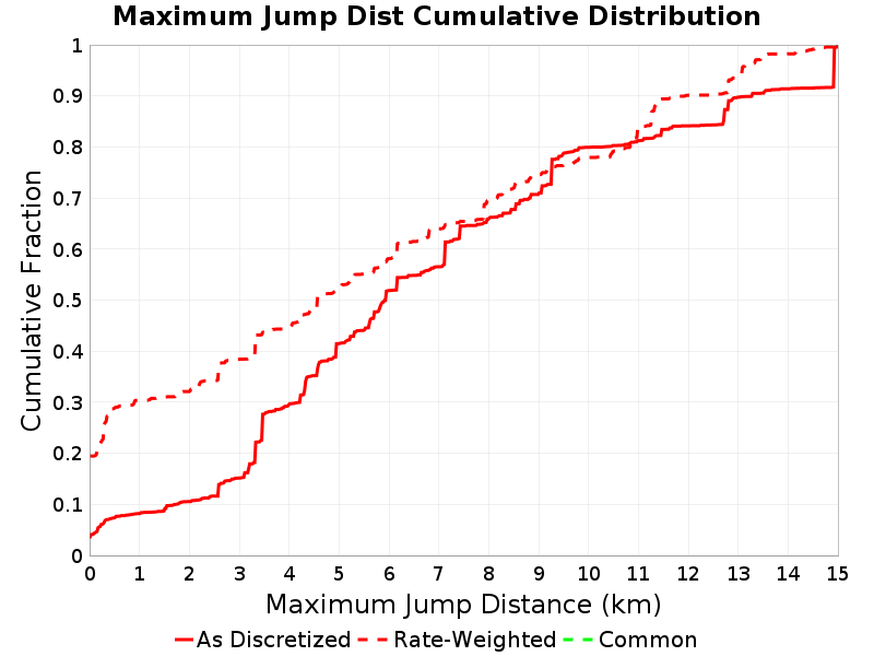
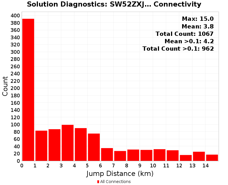
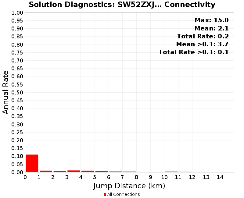
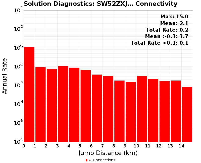
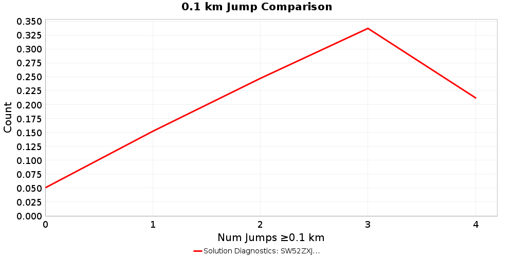
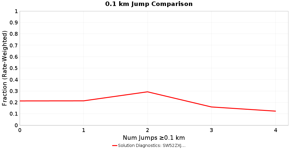
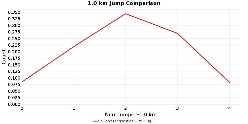
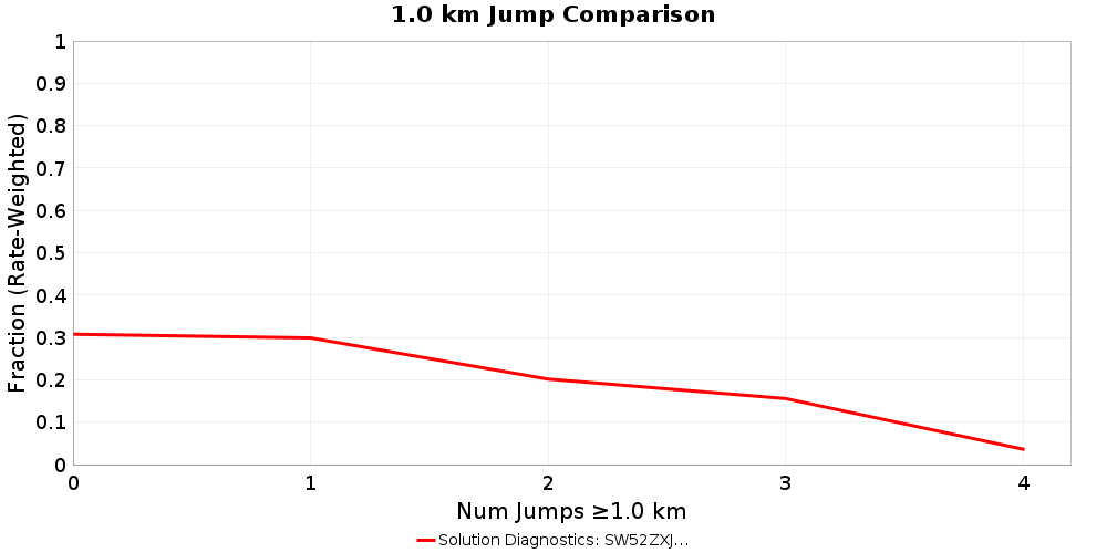
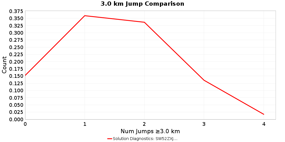
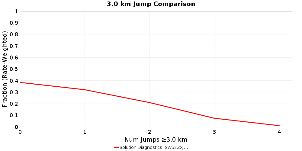
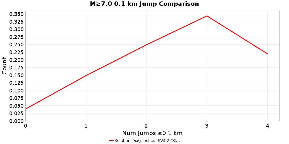
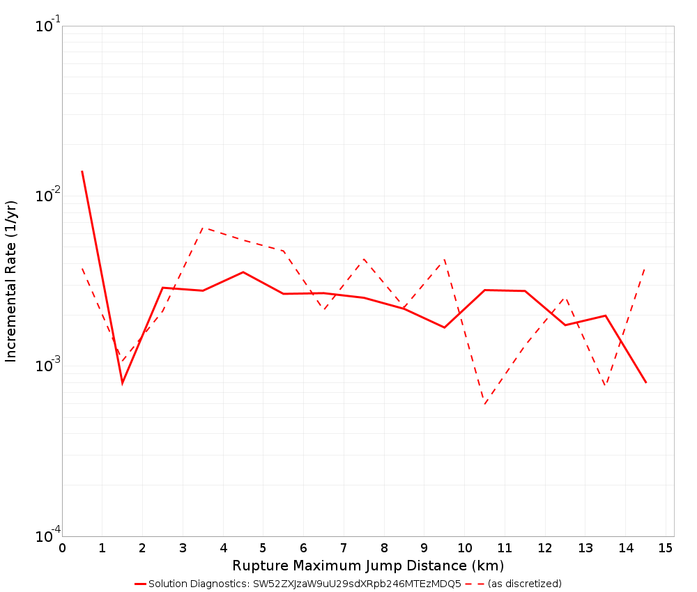
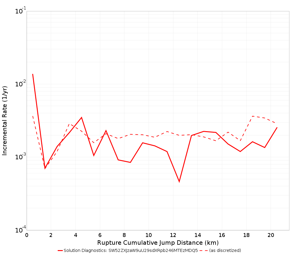
Jump Counts Over Distance
Supra-seismogenic Jump Counts
| As Discretized | Rate Weighted |
|---|---|
 |  |
 |  |
 |  |
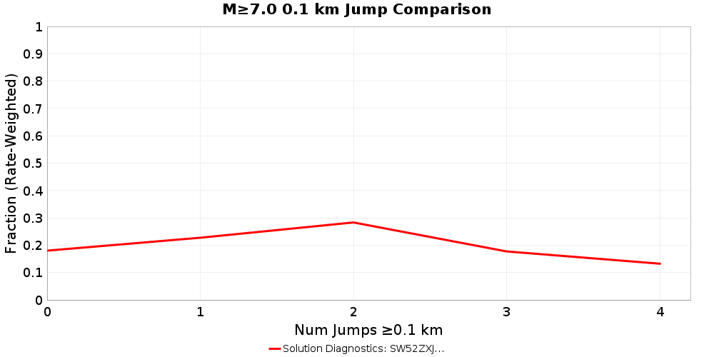
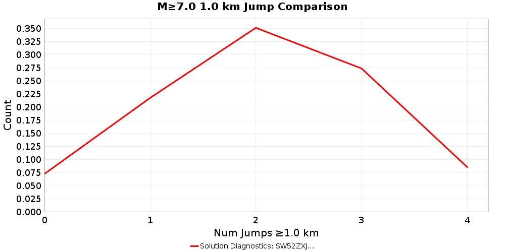
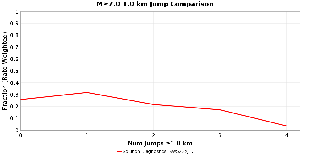
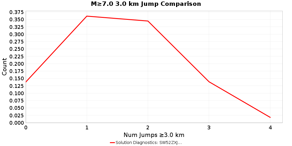
M≥7 Jump Counts
| As Discretized | Rate Weighted |
|---|---|
 |  |
 |  |
 | 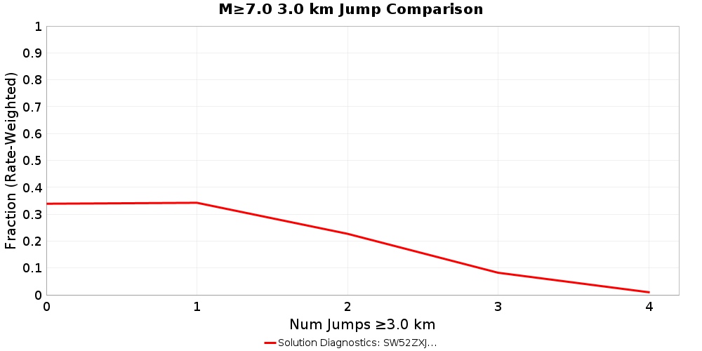 |
Max Jump Distance Distribution
Cumulative Jump Distance Distribution
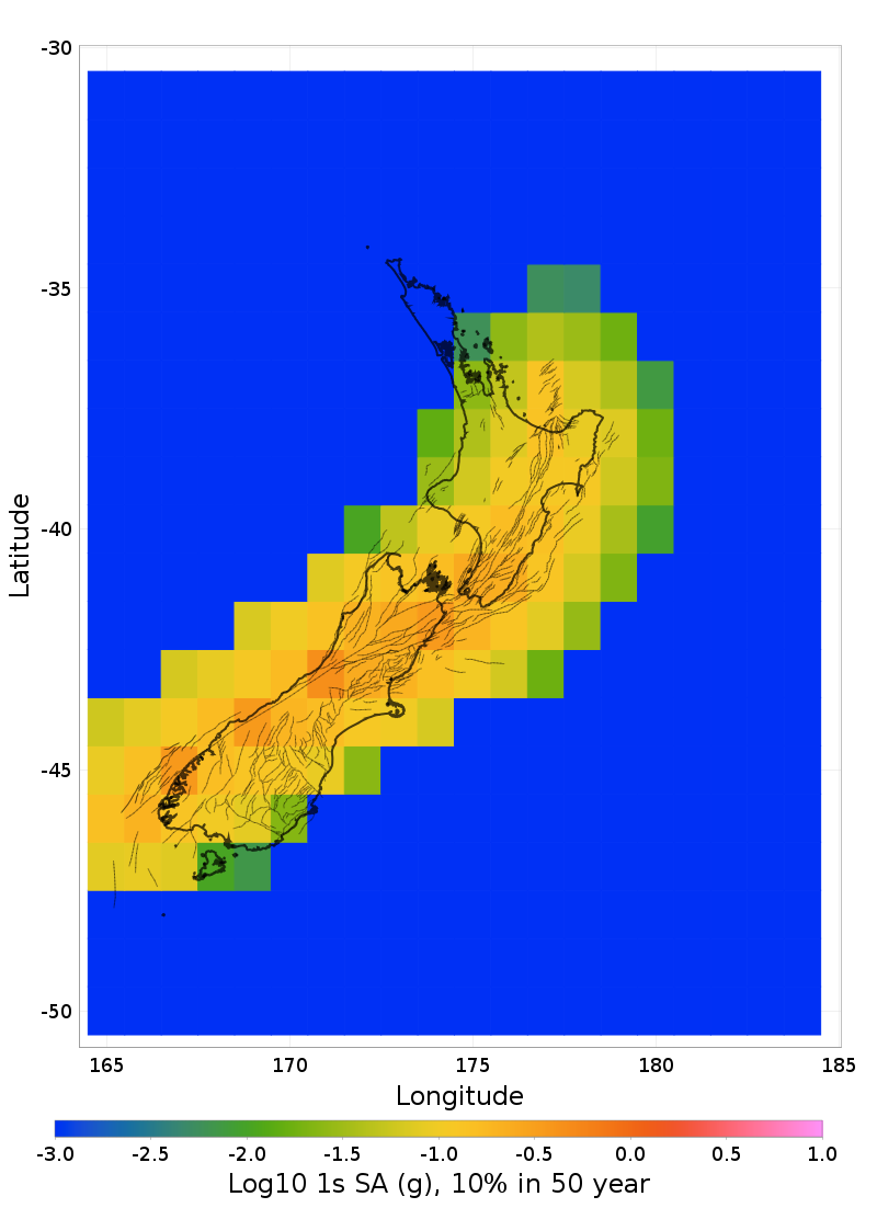
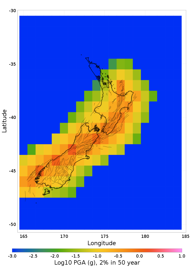
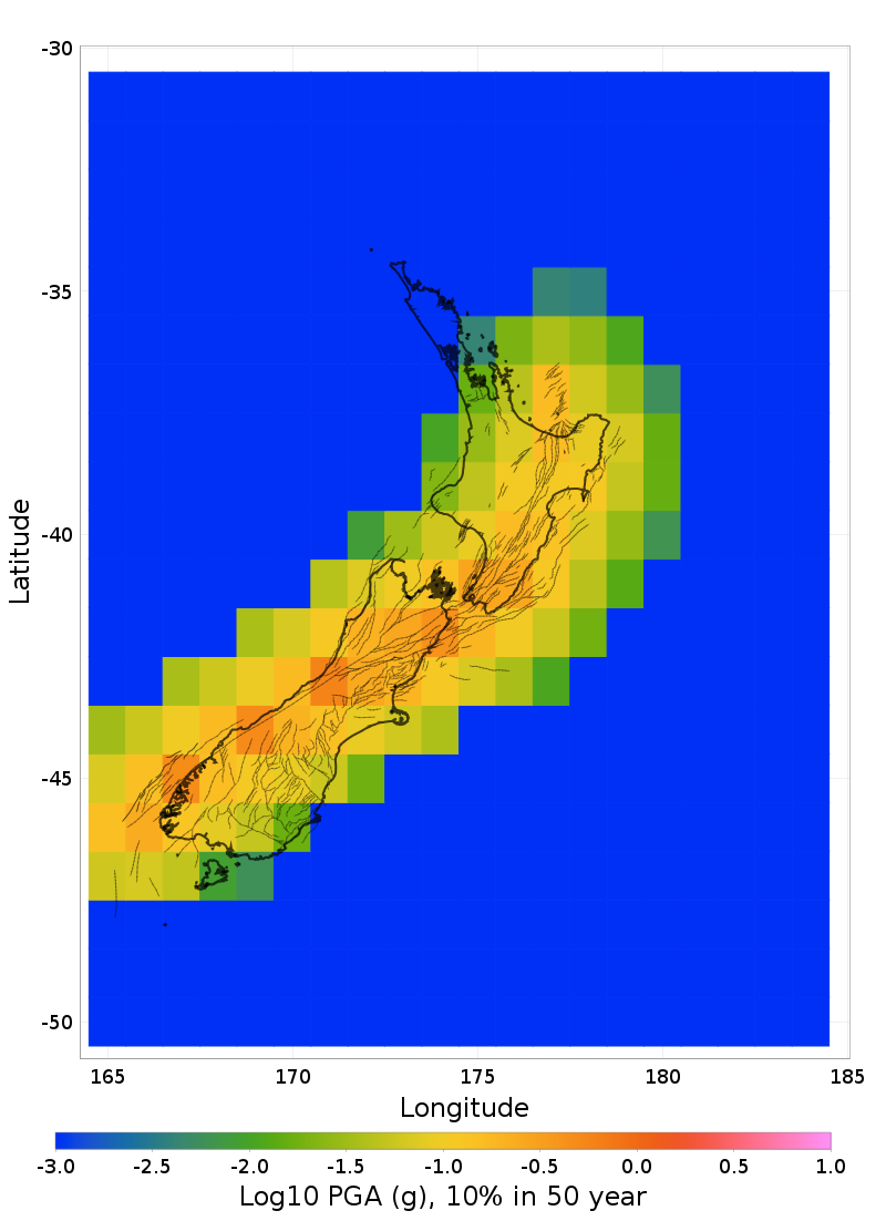
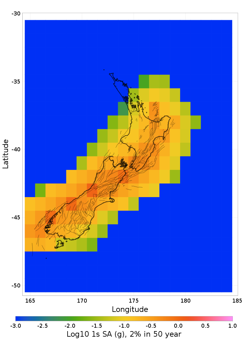
Hazard Maps
Hazard map comparisons with a resolution of 1 degrees (400 sites). Hazard is computed with the ASK2014 GMPE, default site parameters, and supra-seismogenic fault sources only.
PGA Hazard Maps
PGA, 2% in 50 year Hazard Maps
PGA, 10% in 50 year Hazard Maps
1s SA Hazard Maps
1s SA, 2% in 50 year Hazard Maps
1s SA, 10% in 50 year Hazard Maps